roderen2
JCLUTT
User
Length
10.5 km
Max alt
758 m
Uphill gradient
436 m
Km-Effort
16.3 km
Min alt
365 m
Downhill gradient
436 m
Boucle
Yes
Creation date :
2020-05-14 05:45:23.882
Updated on :
2020-05-16 14:37:33.823
3h30
Difficulty : Medium
FREE GPS app for hiking
About
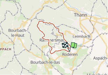
Trail Walking of 10.5 km to be discovered at Grand Est, Haut-Rhin, Roderen. This trail is proposed by JCLUTT.
Description
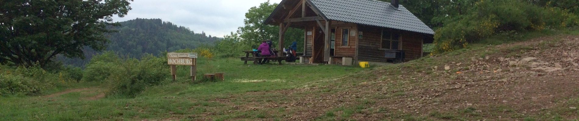
Belle randonnée de reprise d'après confinement. Une bonne montée un peu longue, mais l'abri du Hochburg est magnifique!
Retour par le Baumann et le col du Teufelsgrund.
Positioning
Country:
France
Region :
Grand Est
Department/Province :
Haut-Rhin
Municipality :
Roderen
Location:
Unknown
Start:(Dec)
Start:(UTM)
356894 ; 5293763 (32T) N.
Comments
Trails nearby
Sentheim Rossberg
Walking
Medium
(1)
Sentheim,
Grand Est,
Haut-Rhin,
France
27 km | 40 km-effort
6h 11min
Yes
2024-01-12_14h17m14_239006910
Walking
Difficult
Bourbach-le-Haut,
Grand Est,
Haut-Rhin,
France
11.4 km | 18.5 km-effort
4h 12min
Yes
Sentier géologique du Wolfloch
On foot
Easy
Sentheim,
Grand Est,
Haut-Rhin,
France
3.8 km | 4.8 km-effort
1h 5min
No
Sentheim - Bergwald - Eichwald - Guevenheim - Sentheim
On foot
Easy
(1)
Sentheim,
Grand Est,
Haut-Rhin,
France
13.4 km | 16.6 km-effort
Unknown
Yes
SityTrail - 2489713 - thann-roche--albert--grumbachkopf
Walking
Medium
(1)
Thann,
Grand Est,
Haut-Rhin,
France
7.6 km | 12 km-effort
2h 28min
Yes
68 Col du Hundsrück - FA Gsang - retour ThannerHubel
Walking
Medium
(1)
Bitschwiller-lès-Thann,
Grand Est,
Haut-Rhin,
France
11.2 km | 18.4 km-effort
3h 48min
Yes
Knapphutte Saegenkopf Hütte
Walking
Medium
Sentheim,
Grand Est,
Haut-Rhin,
France
13.8 km | 17.2 km-effort
5h 11min
Yes
Rando du 09/02/2024 par Alain...Pont d'Aspach
Walking
Very difficult
Burnhaupt-le-Haut,
Grand Est,
Haut-Rhin,
France
22 km | 27 km-effort
5h 12min
Yes