Trail Walking Sentheim - Par la forêt et le fil de l'eau - Photo

Par la forêt et le fil de l'eau

 helmut68
helmut68

User

© OpenStreetMap contributors
Length
Length
11.4 km
Max alt
Max alt
403 m
Uphill gradient
Uphill gradient
141 m
Km-Effort
Km-Effort  
13.3 km
Min alt
Min alt
329 m
Downhill gradient
Downhill gradient
142 m
Boucle
Boucle
Yes
Creation date :
2020-05-24 13:00:16.587
Updated on :
2020-05-25 22:22:41.882

(0 Reviews)

Walking
Walking
2h15
Difficulty : Easy

Scan this QR Code to open this trail in the SityTrail application

FREE GPS app for hiking

Logo SityTrail SityTrail

IGN / Geographical institutes

Download SityTrail from the App Store Download SityTrail from Google Play

Logo SityTrail SityTrail World

The world is yours!

Download SityTrail from the App Store Download SityTrail from Google Play Download SityTrail on Huawei AppGallery

About

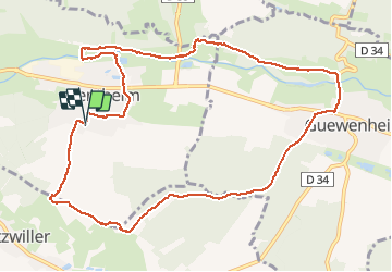
Trail Walking of 11.4 km to be discovered at Grand Est, Haut-Rhin, Sentheim. This trail is proposed by helmut68.

Description

Départ place de jeux de Sentheim, ensuite prenez la route de Mortzwiller durant environ 1 km  pour rejoindre le GR 531( en haut de la butte à votre gauche ). Après 1,5 km tournez à gauche pour suivre la "croix bleu"  jusqu'à la chapelle de Notre-Dame des Bouleaux.
De là direction Guewenhein en suivant le balisage " anneau rouge" , traversez le village et rejoignez la Doller , le cour d'eau de la vallée( rue de Thann), ensuite traversez le pont et suivez le balisage " anneau bleu "( à votre gauche après le pont) jusqu'à Sentheim.
Au début de la randonnée ,vous traverserez une belle forêt jusqu'à la chapelle, pour le retour ça sera au fil de l'eau de la Doller...
Alors à vos chaussures !

Elevation profile

Photos

Positioning

Country:
France
Region :
Grand Est
Department/Province :
Haut-Rhin
Municipality :
Sentheim
Location:
Unknown
Start:(UTM)
353891 ; 5290552 (32T) N.

Trails nearby

Trail Walking Masevaux-Niederbruck - Masevaux - Rossberg par le belvédère du Fuchsfelsen - Photo
Walking
Bart2015

Walking

Medium
(1)
Masevaux-Niederbruck, Grand Est, Haut-Rhin, France
19.9 km | 34 km-effort
4h 44min
Yes
Trail Walking Sentheim - Sentheim Rossberg - Photo
Walking
helmut68

Walking

Medium
(1)
Sentheim, Grand Est, Haut-Rhin, France
27 km | 40 km-effort
6h 11min
Yes
Trail Walking Lauw - 2022-07-14 Marche Lauw Refuge CAF Baerenkopf - Photo
Walking
GUIDE
holtzv

Walking

Very difficult
Lauw, Grand Est, Haut-Rhin, France
18.4 km | 31 km-effort
5h 35min
No
Trail On foot Sentheim - Sentier géologique du Wolfloch - Photo
On foot
PRO

On foot

Easy
Sentheim, Grand Est, Haut-Rhin, France
3.8 km | 4.8 km-effort
1h 5min
No
Trail On foot Sentheim - Sentheim - Bergwald - Eichwald - Guevenheim - Sentheim - Photo
On foot
patrickbeyrath

On foot

Easy
(1)
Sentheim, Grand Est, Haut-Rhin, France
13.4 km | 16.6 km-effort
Unknown
Yes
Trail Walking Sentheim - Knapphutte Saegenkopf Hütte - Photo
Walking
helmut68

Walking

Medium
Sentheim, Grand Est, Haut-Rhin, France
13.8 km | 17.2 km-effort
5h 11min
Yes
Trail Walking Sentheim - Montori - Photo
Walking
helmut68

Walking

Medium
Sentheim, Grand Est, Haut-Rhin, France
17.7 km | 24 km-effort
4h 47min
Yes
Trail Mountain bike Sentheim - AperoDioller - Photo
Mountain bike
helmut68

Mountain bike

Easy
Sentheim, Grand Est, Haut-Rhin, France
24 km | 27 km-effort
1h 23min
Yes
Trail Walking Sentheim - Baerenkopf  - Photo
Walking
helmut68

Walking

Difficult
Sentheim, Grand Est, Haut-Rhin, France
33 km | 49 km-effort
7h 0min
Yes


Close
My subscriptions