Trail Walking Kruth - Lac de Kruth - Grand Ventron - château de Wildenstein  - Photo

Lac de Kruth - Grand Ventron - château de Wildenstein

 Bart2015
Bart2015

User

© OpenStreetMap contributors
Length
Length
19.6 km
Max alt
Max alt
1203 m
Uphill gradient
Uphill gradient
970 m
Km-Effort
Km-Effort  
33 km
Min alt
Min alt
528 m
Downhill gradient
Downhill gradient
967 m
Boucle
Boucle
Yes
Creation date :
2020-07-12 09:40:15.982
Updated on :
2020-08-16 06:53:31.372

(0 Reviews)

Walking
Walking
4h58
Difficulty : Medium

Scan this QR Code to open this trail in the SityTrail application

FREE GPS app for hiking

Logo SityTrail SityTrail

IGN / Geographical institutes

Download SityTrail from the App Store Download SityTrail from Google Play

Logo SityTrail SityTrail World

The world is yours!

Download SityTrail from the App Store Download SityTrail from Google Play Download SityTrail on Huawei AppGallery

About

Trail Walking of 19.6 km to be discovered at Grand Est, Haut-Rhin, Kruth. This trail is proposed by Bart2015.

Description

La rando démarre par les cascades du Bockloch.
Refuge du Hinterbockloch avec possibilité de dormir.
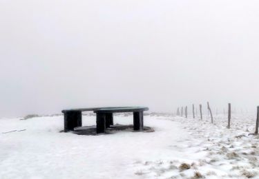
Belle vue depuis la Chaume du Grand Ventron où il est sympa de pique-niquer.
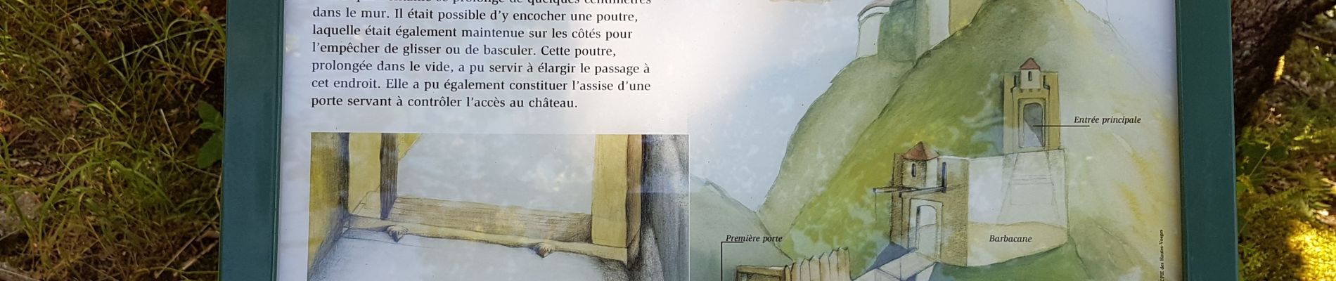
Visite du château de Wildenstein à faire.
Bonne randonnée

Elevation profile

Photos

56 photos in total. Please click on a photo to see them all in the gallery.

Positioning

Country:
France
Region :
Grand Est
Department/Province :
Haut-Rhin
Municipality :
Kruth
Location:
Unknown
Start:(UTM)
347634 ; 5314656 (32T) N.

Trails nearby

Trail Walking Wildenstein - 2022-02-20 Marche Kruth Grand Ventron - Photo
Walking
GUIDE
holtzv

Walking

Very difficult
(1)
Wildenstein, Grand Est, Haut-Rhin, France
16.8 km | 27 km-effort
4h 52min
Yes
Trail Walking La Bresse - Autour du Lac des Corbeaux - Photo
Walking
Alfredy

Walking

Medium
(1)
La Bresse, Grand Est, Vosges, France
3.1 km | 6 km-effort
1h 30min
Yes
Trail Walking Wildenstein - Col du Bramont - Machey - Blanchemer - Photo
Walking
VacheKiri67

Walking

Medium
(1)
Wildenstein, Grand Est, Haut-Rhin, France
15.3 km | 22 km-effort
4h 27min
Yes
Trail Walking La Bresse - Le Lac des Corbeaux - La Bresse - Photo
Walking
tracegps

Walking

Medium
(2)
La Bresse, Grand Est, Vosges, France
3 km | 6 km-effort
2h 0min
Yes
Trail Snowshoes La Bresse - Tour du Lac des Corbeaux - La Bresse - Photo
Snowshoes
tracegps

Snowshoes

Medium
(2)
La Bresse, Grand Est, Vosges, France
6.3 km | 9.7 km-effort
3h 0min
Yes
Trail Walking La Bresse - Tour du Lac des Corbeaux - La Bresse - Photo
Walking
tracegps

Walking

Medium
(3)
La Bresse, Grand Est, Vosges, France
6.3 km | 9.7 km-effort
2h 30min
Yes
Trail Walking Fellering - Felsach _chapelle ST Nicolas_frenz - Photo
Walking
Le grand Claude

Walking

Difficult
(1)
Fellering, Grand Est, Haut-Rhin, France
9.6 km | 16.5 km-effort
3h 45min
Yes
Trail Walking La Bresse - lac des corbeaux, le grand ventron  - Photo
Walking
grattounette

Walking

Difficult
(1)
La Bresse, Grand Est, Vosges, France
22 km | 35 km-effort
7h 39min
Yes
Trail Walking Kruth - barrage de Wildenstein et Grand Ventron - Photo
Walking
egodard

Walking

Medium
(1)
Kruth, Grand Est, Haut-Rhin, France
13.7 km | 24 km-effort
4h 40min
Yes


Close
My subscriptions