![](/images/other/stat-length.png)
![Trail Walking La Roche-en-Ardenne - Samree-maboge-Samree - Photo](https://media.geolcdn.com/t/1900/400/ext.pjpeg?maxdim=2&url=https%3A%2F%2Fmedia.geolcdn.com%2Ff%2Fb1140dd6-ef3b-4be2-9da7-c3279afff05d.jpeg)
Samree-maboge-Samree
negi
User
![Length](/images/other/stat-length.png)
Length
15.2 km
![Max alt](https://static1.geolcdn.com/siteimages/upload/files/1508320355ic_sort_altitude_max_24dp.png)
Max alt
567 m
![Uphill gradient](https://static1.geolcdn.com/siteimages/upload/files/1508320355ic_sort_den_pos_24dp.png)
Uphill gradient
417 m
![Km-Effort](/images/other/stat-length.png)
Km-Effort
21 km
![Min alt](https://static1.geolcdn.com/siteimages/upload/files/1508320355ic_sort_altitude_min_24dp.png)
Min alt
239 m
![Downhill gradient](https://static1.geolcdn.com/siteimages/upload/files/1508320355ic_sort_den_neg_24dp.png)
Downhill gradient
422 m
![Boucle](https://static1.geolcdn.com/siteimages/upload/files/16400158638029165_repeat_loop_refresh_sync_direction_icon.png)
Boucle
Yes
Creation date :
2020-07-19 07:02:24.0
Updated on :
2020-07-19 12:04:57.517
![Walking](https://static1.geolcdn.com/sitytour/trail-icons/101.png)
3h36
Difficulty : Unknown
![Scan this QR Code to open this trail in the SityTrail application](https://capi.geolives.com/qq0zvz2zws4bq2lad0pu/sitytour/trails/2481562/qr.png?size=200)
FREE GPS app for hiking
About
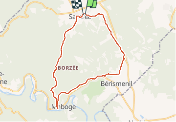
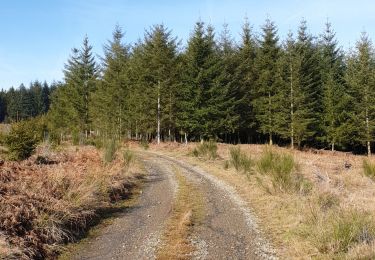
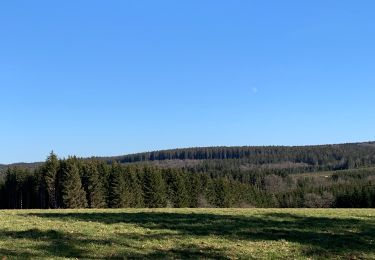
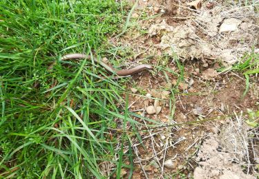
Trail Walking of 15.2 km to be discovered at Wallonia, Luxembourg, La Roche-en-Ardenne. This trail is proposed by negi.
Description
Belle rando nature et sportive. Après Berismenil vous découvrirez un site colonisé par les castors et avec un peu de chance, les observer.
Positioning
Country:
Belgium
Region :
Wallonia
Department/Province :
Luxembourg
Municipality :
La Roche-en-Ardenne
Location:
Samrée
Start:(Dec)
Start:(UTM)
688584 ; 5565358 (31U) N.
Comments
Trails nearby
![Trail Walking La Roche-en-Ardenne - RB-Lu-05 - Au gré de l’Ourthe, la balade des panoramas - Photo](https://media.geolcdn.com/t/375/260/ext.jpg?maxdim=2&url=https%3A%2F%2Fservices.sitytrail.com%2FGeolivesWS%2FDownloadMedia.ashx%3FTrailID%3D179614%26Media%3Ddb2598db-79d7-4bc8-afb7-55d65e443283.jpg)
![Walking Walking](https://static1.geolcdn.com/sitytour/trail-icons/101.png)
RB-Lu-05 - Au gré de l’Ourthe, la balade des panoramas
Walking
Medium
(6)
La Roche-en-Ardenne,
Wallonia,
Luxembourg,
Belgium
![](/images/other/stat-length.png)
23 km | 34 km-effort
6h 52min
![](https://static1.geolcdn.com/siteimages/upload/files/16400158638029165_repeat_loop_refresh_sync_direction_icon.png)
Yes
![Trail Walking La Roche-en-Ardenne - Bérismenil - Circuit Natura 2000, des sites qui valent le détour - Lx19 - Photo](https://media.geolcdn.com/t/375/260/ext.jpg?maxdim=2&url=https%3A%2F%2Fservices.sitytrail.com%2FGeolivesWS%2FDownloadMedia.ashx%3FTrailID%3D356413%26Media%3D926c17f8-7479-49f8-a1c9-842bf0b93137.JPG)
![Walking Walking](https://static1.geolcdn.com/sitytour/trail-icons/101.png)
Bérismenil - Circuit Natura 2000, des sites qui valent le détour - Lx19
Walking
Medium
(3)
La Roche-en-Ardenne,
Wallonia,
Luxembourg,
Belgium
![](/images/other/stat-length.png)
7.4 km | 10.4 km-effort
2h 15min
![](https://static1.geolcdn.com/siteimages/upload/files/16400158638029165_repeat_loop_refresh_sync_direction_icon.png)
Yes
![Trail Walking La Roche-en-Ardenne - rando samrée 26/11/2020 - Photo](https://media.geolcdn.com/t/375/260/ext.jpg?maxdim=2&url=https%3A%2F%2Fmedia.geolcdn.com%2Ff%2Fb9b92636-327b-470f-9fef-3742386ec0a6.jpg)
![Walking Walking](https://static1.geolcdn.com/sitytour/trail-icons/101.png)
rando samrée 26/11/2020
Walking
Medium
(2)
La Roche-en-Ardenne,
Wallonia,
Luxembourg,
Belgium
![](/images/other/stat-length.png)
19 km | 25 km-effort
4h 44min
![](https://static1.geolcdn.com/siteimages/upload/files/16400158638029165_repeat_loop_refresh_sync_direction_icon.png)
Yes
![Trail Walking La Roche-en-Ardenne - Balade à Samrée - Photo](https://media.geolcdn.com/t/375/260/ext.jpg?maxdim=2&url=https%3A%2F%2Fmedia.geolcdn.com%2Ff%2F8ac758ba-e05d-40e0-9a71-4c66a47c27c2.jpg)
![Walking Walking](https://static1.geolcdn.com/sitytour/trail-icons/101.png)
Balade à Samrée
Walking
Very easy
(1)
La Roche-en-Ardenne,
Wallonia,
Luxembourg,
Belgium
![](/images/other/stat-length.png)
11.2 km | 15.7 km-effort
4h 30min
![](https://static1.geolcdn.com/siteimages/upload/files/16400158638029165_repeat_loop_refresh_sync_direction_icon.png)
Yes
![Trail Walking La Roche-en-Ardenne - Celtes et Ourthe - Photo](https://media.geolcdn.com/t/375/260/ext.jpg?maxdim=2&url=https%3A%2F%2Fservices.sitytrail.com%2FGeolivesWS%2FDownloadMedia.ashx%3FTrailID%3D854402%26Media%3Dfix__20171030123801.jpg)
![Walking Walking](https://static1.geolcdn.com/sitytour/trail-icons/101.png)
Celtes et Ourthe
Walking
Difficult
(1)
La Roche-en-Ardenne,
Wallonia,
Luxembourg,
Belgium
![](/images/other/stat-length.png)
9.8 km | 13.4 km-effort
3h 4min
![](https://static1.geolcdn.com/siteimages/upload/files/16400158638029165_repeat_loop_refresh_sync_direction_icon.png)
Yes
![Trail Walking La Roche-en-Ardenne - Un petit tour dans les fagnes de la goutte en partant de Samree - Photo](https://media.geolcdn.com/t/375/260/ext.jpg?maxdim=2&url=https%3A%2F%2Fmedia.geolcdn.com%2Ff%2Ffaa437e4-187a-4ff0-9cbb-6255b11e3348.jpg)
![Walking Walking](https://static1.geolcdn.com/sitytour/trail-icons/101.png)
Un petit tour dans les fagnes de la goutte en partant de Samree
Walking
(2)
La Roche-en-Ardenne,
Wallonia,
Luxembourg,
Belgium
![](/images/other/stat-length.png)
14.6 km | 18.5 km-effort
3h 0min
![](https://static1.geolcdn.com/siteimages/upload/files/16400158638029165_repeat_loop_refresh_sync_direction_icon.png)
Yes
![Trail Walking La Roche-en-Ardenne - très belle - Photo](https://media.geolcdn.com/t/375/260/ext.jpg?maxdim=2&url=https%3A%2F%2Fmedia.geolcdn.com%2Ff%2F20ac222d-4563-44a0-a49e-63d4fb5a1b07.jpg)
![Walking Walking](https://static1.geolcdn.com/sitytour/trail-icons/101.png)
très belle
Walking
Very easy
(1)
La Roche-en-Ardenne,
Wallonia,
Luxembourg,
Belgium
![](/images/other/stat-length.png)
22 km | 31 km-effort
4h 49min
![](https://static1.geolcdn.com/siteimages/upload/files/16400158638029165_repeat_loop_refresh_sync_direction_icon.png)
Yes
![Trail Walking Manhay - RF-Lu-04 En surplomb de l'ancienne ligne SNCV de l'Aisne : Dochamps - Photo](https://media.geolcdn.com/t/375/260/ext.jpg?maxdim=2&url=https%3A%2F%2Fstatic1.geolcdn.com%2Fsiteimages%2Fupload%2Ffiles%2F1553511878bg_sport_marche.png)
![Walking Walking](https://static1.geolcdn.com/sitytour/trail-icons/101.png)
RF-Lu-04 En surplomb de l'ancienne ligne SNCV de l'Aisne : Dochamps
Walking
Very easy
(4)
Manhay,
Wallonia,
Luxembourg,
Belgium
![](/images/other/stat-length.png)
14.4 km | 19.2 km-effort
4h 5min
![](https://static1.geolcdn.com/siteimages/upload/files/16400158638029165_repeat_loop_refresh_sync_direction_icon.png)
Yes
![Trail Mountain bike Manhay - O2bikers_142_dochamps - Photo](https://media.geolcdn.com/t/375/260/ext.jpg?maxdim=2&url=https%3A%2F%2Fstatic1.geolcdn.com%2Fsiteimages%2Fupload%2Ffiles%2F1524743154velo.jpg)
![Mountain bike Mountain bike](https://static1.geolcdn.com/sitytour/trail-icons/202.png)
O2bikers_142_dochamps
Mountain bike
Very easy
(5)
Manhay,
Wallonia,
Luxembourg,
Belgium
![](/images/other/stat-length.png)
37 km | 50 km-effort
Unknown
![](https://static1.geolcdn.com/siteimages/upload/files/16400158638029165_repeat_loop_refresh_sync_direction_icon.png)
Yes
Très belle balade