Trail Walking Wuenheim - SityTrail - Wuenheim_Thierenbach - Photo

SityTrail - Wuenheim_Thierenbach

Jetz geht's wieder los, noch dem bloede COVID19

© OpenStreetMap contributors
Length
Length
11.1 km
Max alt
Max alt
579 m
Uphill gradient
Uphill gradient
344 m
Km-Effort
Km-Effort  
15.6 km
Min alt
Min alt
297 m
Downhill gradient
Downhill gradient
341 m
Boucle
Boucle
Yes
Creation date :
2020-10-28 16:30:18.37
Updated on :
2020-10-28 16:40:07.565

(0 Reviews)

Walking
Walking
3h16
Difficulty : Medium

Scan this QR Code to open this trail in the SityTrail application

FREE GPS app for hiking

Logo SityTrail SityTrail

IGN / Geographical institutes

Download SityTrail from the App Store Download SityTrail from Google Play

Logo SityTrail SityTrail World

The world is yours!

Download SityTrail from the App Store Download SityTrail from Google Play Download SityTrail on Huawei AppGallery

About

Trail Walking of 11.1 km to be discovered at Grand Est, Haut-Rhin, Wuenheim. This trail is proposed by Seppala - Balades du jeudi.

Description

Une balade facile autour de Thierenbach, dénivelé 340 m sur 11 km.
Le retour peut être considérablement raccourci en cas de pluie.
           
ACCÈS :
Par Soultz, direction Jungholtz, à  la sortie de Soultz, à l'embranchement bifurquer vers Wuenheim. Prendre la direction camping de la sapinière et col Amic.

PARKING :
- au parcours sportif au dessus de Wuenheim en face du stand de tir
47.875228 ,   7.191593   ou        
N 47°52'31",  E  007°11'30"      

RESTAURATION :    
Ferme des Moines à Thierenbach
Tél.: 03 89 76 93 01

Elevation profile

Positioning

Country:
France
Region :
Grand Est
Department/Province :
Haut-Rhin
Municipality :
Wuenheim
Location:
Unknown
Start:(UTM)
364780 ; 5303991 (32T) N.

Trails nearby

Trail Walking Soultz-Haut-Rhin - Hartmannswillerkopf - Circuit découverte - Photo
Walking
VacheKiri67

Walking

Easy
(1)
Soultz-Haut-Rhin, Grand Est, Haut-Rhin, France
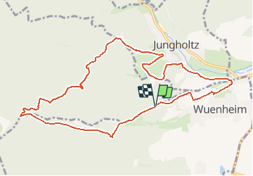
3.6 km | 5.2 km-effort
1h 46min
Yes
Trail Walking Soultz-Haut-Rhin - Hartmannswillerkopf - Circuit anneau bleu - Photo
Walking
VacheKiri67

Walking

Medium
(1)
Soultz-Haut-Rhin, Grand Est, Haut-Rhin, France
3.7 km | 5.9 km-effort
1h 37min
Yes
Trail On foot Goldbach-Altenbach - Firstacker - Willer sur Thur - Photo
On foot
PRO

On foot

Easy
Goldbach-Altenbach, Grand Est, Haut-Rhin, France
7.4 km | 9.6 km-effort
2h 11min
No
Trail Mountain bike Guebwiller - P4  Circuits du Florival 2021   - Photo
Mountain bike
duchaine.nicolas

Mountain bike

Medium
(1)
Guebwiller, Grand Est, Haut-Rhin, France
40 km | 53 km-effort
4h 31min
No
Trail Trail Wattwiller - The History Ultra - stage 1 - Photo
Trail
Olivier Houette

Trail

Very easy
(1)
Wattwiller, Grand Est, Haut-Rhin, France
28 km | 48 km-effort
Unknown
No
Trail Walking Soultz-Haut-Rhin - Rando Marcheurs..04/04_2025 - Photo
Walking
boubou68

Walking

Very difficult
Soultz-Haut-Rhin, Grand Est, Haut-Rhin, France
21 km | 35 km-effort
4h 42min
Yes
Trail Walking Jungholtz - Rando Retrouvailles...01/03/2024.par Jean Marc - Photo
Walking
boubou68

Walking

Very difficult
Jungholtz, Grand Est, Haut-Rhin, France
11.3 km | 19.2 km-effort
1h 35min
Yes
Trail Walking Wattwiller - Wattwiller - Domaine du Hirtz (30/03/2023) - Photo
Walking
Richard68500

Walking

Easy
Wattwiller, Grand Est, Haut-Rhin, France
6.1 km | 9.9 km-effort
2h 7min
Yes
Trail Walking Soultz-Haut-Rhin - Rando avec 0mar et Mouloud..18/02/2023 - Photo
Walking
boubou68

Walking

Very difficult
Soultz-Haut-Rhin, Grand Est, Haut-Rhin, France
12 km | 20 km-effort
3h 9min
Yes


Close
My subscriptions