Trail Mountain bike Port-Valais - Lac Tanay pour les sportifs - Photo

Lac Tanay pour les sportifs

 otrement
otrement

User

© OpenStreetMap contributors
Length
Length
24 km
Max alt
Max alt
1476 m
Uphill gradient
Uphill gradient
1202 m
Km-Effort
Km-Effort  
40 km
Min alt
Min alt
371 m
Downhill gradient
Downhill gradient
1204 m
Boucle
Boucle
Yes
Creation date :
2014-12-11 00:00:00.0
Updated on :
2014-12-11 00:00:00.0

(0 Reviews)

Mountain bike
Mountain bike
2h57
Difficulty : Unknown

Scan this QR Code to open this trail in the SityTrail application

FREE GPS app for hiking

Logo SityTrail SityTrail

IGN / Geographical institutes

Download SityTrail from the App Store Download SityTrail from Google Play

Logo SityTrail SityTrail World

The world is yours!

Download SityTrail from the App Store Download SityTrail from Google Play Download SityTrail on Huawei AppGallery

About

Trail Mountain bike of 24 km to be discovered at Valais/Wallis, Monthey, Port-Valais. This trail is proposed by otrement.

Description

Au départ du Bouveret, petit échauffement jusqu''à Vouvry. Ensuite nous empruntons l''ancienne route jusqu''à Miex. Ca monte déjà pas mal ! Profitons du repos jusqu''au flon car la montée sur le col de Tanay est encore plus raide! Une fois au lac de Tanay, il reste un petit portage avant de basculer sur le lac Léman et de dévaler les 1000m. de descente sur un chemin de toute beauté. Bien du plaisir!

Elevation profile

Points of interest

Point of interest Port-Valais - Les Evouettes - Photo
otrement
PORT-VALAIS 
Point of interest Vouvry - Lac Tanay - Photo
otrement
VOUVRY 
Point of interest Port-Valais - Chalavornaire - Photo
otrement
PORT-VALAIS 
Point of interest Vouvry - Miex - Photo
otrement
VOUVRY 
Point of interest Vouvry - Vouvry - Photo
otrement
VOUVRY 
Point of interest Port-Valais - Ecole Bouveret - Photo
otrement
PORT-VALAIS 

Positioning

Country:
Switzerland
Region :
Valais/Wallis
Department/Province :
Monthey
Municipality :
Port-Valais
Location:
Unknown
Start:(UTM)
335162 ; 5138925 (32T) N.

Trails nearby

Trail On foot Vouvry - Miex-Lac Tanay (via Prélagine) - Photo
On foot
PRO

On foot

Easy
Vouvry, Valais/Wallis, Monthey, Switzerland
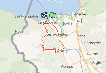
6.3 km | 9.9 km-effort
2h 15min
No
Trail Mountain bike Saint-Gingolph - TransAlpes VTT - 01/25 - St Gingolf - Lac de Tanay - Photo
Mountain bike
tracegps

Mountain bike

Difficult
Saint-Gingolph, Valais/Wallis, Monthey, Switzerland
13.8 km | 27 km-effort
2h 30min
No
Trail Other activity Saint-Gingolph - bdx001_0623 - Photo
Other activity
GUIDE+

Other activity

Very easy
Saint-Gingolph, Valais/Wallis, Monthey, Switzerland
11.3 km | 35 km-effort
8h 5min
No
Trail Other activity Saint-Gingolph - ST_harlin_test - Photo
Other activity
GUIDE+

Other activity

Very easy
Saint-Gingolph, Auvergne-Rhône-Alpes, Upper Savoy, France
32 km | 84 km-effort
14h 44min
No
Trail Other activity Le Léman (VS) - bdr99_StGingolphe_Leysin - Photo
Other activity
GUIDE+

Other activity

Very easy
Le Léman (VS), Valais/Wallis, Monthey, Switzerland
26 km | 38 km-effort
8h 59min
No
Trail Other activity Le Léman (VS) - bdr01_StGingolphe_Trient - Photo
Other activity
GUIDE+

Other activity

Very easy
Le Léman (VS), Valais/Wallis, Monthey, Switzerland
68 km | 170 km-effort
40h 54min
No
Trail Other activity Saint-Gingolph - xxx20_Heremence_StGingolphe - Photo
Other activity
GUIDE+

Other activity

Very easy
Saint-Gingolph, Valais/Wallis, Monthey, Switzerland
59 km | 59 km-effort
13h 24min
No
Trail sport Saint-Gingolph - Etape1 St Gingolph-Refuge Chalets de Bise - Photo
sport
anne.legrand

sport

Very easy
Saint-Gingolph, Valais/Wallis, Monthey, Switzerland
11.2 km | 28 km-effort
Unknown
No
Trail Road bike Port-Valais - st ginghof le Bouveret, /messery  - Photo
Road bike
levequejef

Road bike

Very easy
Port-Valais, Valais/Wallis, Monthey, Switzerland
60 km | 69 km-effort
6h 37min
No


Close
My subscriptions