Trail Mountain bike Cabestany - cab Réart étang  - Photo
© OpenStreetMap contributors
Length
Length
44 km
Max alt
Max alt
42 m
Uphill gradient
Uphill gradient
247 m
Km-Effort
Km-Effort  
47 km
Min alt
Min alt
-3 m
Downhill gradient
Downhill gradient
247 m
Boucle
Boucle
Yes
Creation date :
2020-11-25 07:49:20.956
Updated on :
2020-11-25 17:59:12.887

(0 Reviews)

Mountain bike
Mountain bike
3h11
Difficulty : Easy

Scan this QR Code to open this trail in the SityTrail application

FREE GPS app for hiking

Logo SityTrail SityTrail

IGN / Geographical institutes

Download SityTrail from the App Store Download SityTrail from Google Play

Logo SityTrail SityTrail World

The world is yours!

Download SityTrail from the App Store Download SityTrail from Google Play Download SityTrail on Huawei AppGallery

About

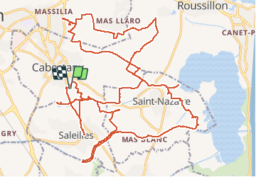
Trail Mountain bike of 44 km to be discovered at Occitania, Pyrénées-Orientales, Cabestany. This trail is proposed by Michel Pontie.

Description

cab fosseille Réart étang chateau del Rey mas llaro les Lloberes rte st Naz Cab saleilles Cabes

Elevation profile

Positioning

Country:
France
Region :
Occitania
Department/Province :
Pyrénées-Orientales
Municipality :
Cabestany
Location:
Unknown
Start:(UTM)
495614 ; 4724410 (31T) N.

Trails nearby

Trail Walking Théza - 66 THEZA - CORNEILLA-DEL-VERCOL - Photo
Walking
jeff66

Walking

Easy
(2)
Théza, Occitania, Pyrénées-Orientales, France
7 km | 7.5 km-effort
1h 8min
Yes
Trail Walking Cabestany - Chemins autour de Cabestany - Photo
Walking
tracegps

Walking

Medium
(2)
Cabestany, Occitania, Pyrénées-Orientales, France
11.8 km | 12.7 km-effort
3h 0min
Yes
Trail Walking Perpignan - Perpignan 01.10.2017  - Photo
Walking
jeff66

Walking

Easy
(1)
Perpignan, Occitania, Pyrénées-Orientales, France
6.7 km | 7.5 km-effort
1h 39min
No
Trail Walking Villeneuve-de-la-Raho - 66 VILLENEUVE-DE-LA-RAHO - grand tour périphérique du lac par les lignes de crêtes  - Photo
Walking
jeff66

Walking

Easy
(2)
Villeneuve-de-la-Raho, Occitania, Pyrénées-Orientales, France
10 km | 11.5 km-effort
1h 44min
Yes
Trail Walking Saleilles - 66 SALEILLES - St-NAZAIRE, entre FOSSEILLE et REART - Photo
Walking
jeff66

Walking

Easy
(1)
Saleilles, Occitania, Pyrénées-Orientales, France
7.3 km | 7.7 km-effort
1h 8min
Yes
Trail Walking Perpignan - Perpignan  - Photo
Walking
ombrabella

Walking

Very easy
Perpignan, Occitania, Pyrénées-Orientales, France
18 km | 19.9 km-effort
2h 23min
No
Trail Walking Perpignan - 66 PERPIGNAN, quartier MAV au Bas Vernet  - Photo
Walking
jeff66

Walking

Easy
Perpignan, Occitania, Pyrénées-Orientales, France
10.7 km | 11.8 km-effort
1h 45min
Yes
Trail Walking Bompas - 66 BOMPAS - itinéraire partagé piétions cycliste en bord de Tet, berge Têt, Bas Vernet, retour par les canaux et centre ville de BOMPAS  - Photo
Walking
jeff66

Walking

Medium
Bompas, Occitania, Pyrénées-Orientales, France
13.4 km | 14.2 km-effort
2h 23min
Yes
Trail Walking Perpignan - 66 PERPIGNAN - mas Balande, parc des sports, aviateurs, St Martin, MAV, Vertefeuille - Photo
Walking
jeff66

Walking

Easy
Perpignan, Occitania, Pyrénées-Orientales, France
10.6 km | 11.6 km-effort
1h 52min
Yes


Close
My subscriptions