Trail Walking Saint-Tropez - SityTrail - PRESQU'ÎLE DE SAINT TROPEZ - Photo

SityTrail - PRESQU'ÎLE DE SAINT TROPEZ

 kikujiro
kikujiro

User

© OpenStreetMap contributors
Length
Length
10.7 km
Max alt
Max alt
85 m
Uphill gradient
Uphill gradient
171 m
Km-Effort
Km-Effort  
13 km
Min alt
Min alt
0 m
Downhill gradient
Downhill gradient
172 m
Boucle
Boucle
Yes
Creation date :
2021-02-23 19:38:15.846
Updated on :
2021-02-23 20:00:21.856

(0 Reviews)

Walking
Walking
2h56
Difficulty : Easy

Scan this QR Code to open this trail in the SityTrail application

FREE GPS app for hiking

Logo SityTrail SityTrail

IGN / Geographical institutes

Download SityTrail from the App Store Download SityTrail from Google Play

Logo SityTrail SityTrail World

The world is yours!

Download SityTrail from the App Store Download SityTrail from Google Play Download SityTrail on Huawei AppGallery

About

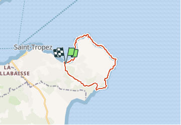
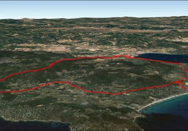
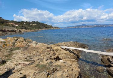
Trail Walking of 10.7 km to be discovered at Provence-Alpes-Côte d'Azur, Var, Saint-Tropez. This trail is proposed by kikujiro.

Description

circuit de la baie des Canebiers vers pointe de la Rabiou cap de Saint-Tropez cap des Salins pointe de Capon cap du Pinet et retour à baie des Canebiers par Capon.

Elevation profile

Positioning

Country:
France
Region :
Provence-Alpes-Côte d'Azur
Department/Province :
Var
Municipality :
Saint-Tropez
Location:
Unknown
Start:(UTM)
310339 ; 4792812 (32T) N.

Trails nearby

Trail Walking Saint-Tropez - PRESQU'ÎLE DE SAINT TROPEZ - Photo
Walking
jean-marie.parachini

Walking

Medium
(3)
Saint-Tropez, Provence-Alpes-Côte d'Azur, Var, France
12.2 km | 14.7 km-effort
5h 19min
Yes
Trail Walking Saint-Tropez - Saint Tropez  - Photo
Walking
juleyann

Walking

Easy
(1)
Saint-Tropez, Provence-Alpes-Côte d'Azur, Var, France
11.7 km | 13.7 km-effort
4h 19min
No
Trail Walking Ramatuelle - chemin du littoral : Pampelone St Tropez - Photo
Walking
BLANCHET

Walking

Easy
(3)
Ramatuelle, Provence-Alpes-Côte d'Azur, Var, France
13.2 km | 15.6 km-effort
3h 20min
No
Trail Walking Saint-Tropez - Golfe de St Tropez - Photo
Walking
tracegps

Walking

Difficult
(2)
Saint-Tropez, Provence-Alpes-Côte d'Azur, Var, France
15.1 km | 17.6 km-effort
4h 30min
Yes
Trail Walking Saint-Tropez - St tropez calanque - Photo
Walking
michel1951

Walking

Medium
(1)
Saint-Tropez, Provence-Alpes-Côte d'Azur, Var, France
9.9 km | 11.4 km-effort
3h 52min
Yes
Trail Mountain bike Ramatuelle - SityTrail - Ramatuelle - Ballade dans et autour de Ramatuelle - Moulin de Paillas - La roulliere - Photo
Mountain bike
GUIDE
affinetataille

Mountain bike

Medium
(1)
Ramatuelle, Provence-Alpes-Côte d'Azur, Var, France
23 km | 30 km-effort
2h 3min
Yes
Trail Mountain bike Ramatuelle - Ramatuelle moulins de Paillas et Patapans.gpx - Photo
Mountain bike
ves

Mountain bike

Medium
(1)
Ramatuelle, Provence-Alpes-Côte d'Azur, Var, France
19.8 km | 26 km-effort
2h 22min
No
Trail Mountain bike Ramatuelle - VTT Mataranne - Paillas - Gassin - St Tropez - Photo
Mountain bike
GUIDE
affinetataille

Mountain bike

Medium
Ramatuelle, Provence-Alpes-Côte d'Azur, Var, France
30 km | 37 km-effort
3h 0min
Yes
Trail Walking Saint-Tropez - St Tropez littoral - Photo
Walking
Ninie38MD

Walking

Medium
Saint-Tropez, Provence-Alpes-Côte d'Azur, Var, France
18.3 km | 22 km-effort
6h 3min
Yes


Close
My subscriptions