Trail Mountain bike Cervens - chateaux des Alinges la grotte aux loup - Photo

chateaux des Alinges la grotte aux loup

© OpenStreetMap contributors
Length
Length
16.3 km
Max alt
Max alt
735 m
Uphill gradient
Uphill gradient
413 m
Km-Effort
Km-Effort  
22 km
Min alt
Min alt
558 m
Downhill gradient
Downhill gradient
413 m
Boucle
Boucle
Yes
Creation date :
2021-04-11 08:16:56.822
Updated on :
2021-04-25 16:57:22.944

(0 Reviews)

Mountain bike
Mountain bike
1h27
Difficulty : Very easy

Scan this QR Code to open this trail in the SityTrail application

FREE GPS app for hiking

Logo SityTrail SityTrail

IGN / Geographical institutes

Download SityTrail from the App Store Download SityTrail from Google Play

Logo SityTrail SityTrail World

The world is yours!

Download SityTrail from the App Store Download SityTrail from Google Play Download SityTrail on Huawei AppGallery

About

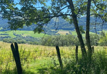
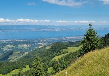
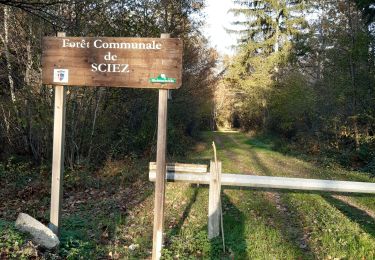
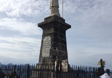
Trail Mountain bike of 16.3 km to be discovered at Auvergne-Rhône-Alpes, Upper Savoy, Cervens. This trail is proposed by al.lergen .

Description

Une difficulté, la descente vers Perrignier après la grotte (pas par temps humide!!!)

Elevation profile

Positioning

Country:
France
Region :
Auvergne-Rhône-Alpes
Department/Province :
Upper Savoy
Municipality :
Cervens
Location:
Unknown
Start:(UTM)
302946 ; 5128835 (32T) N.

Trails nearby

Trail Walking Habère-Poche - Mont Forchat - Habère Poche - Ramble - Photo
Walking
tracegps

Walking

Medium
(2)
Habère-Poche, Auvergne-Rhône-Alpes, Upper Savoy, France
10.7 km | 18.6 km-effort
4h 0min
Yes
Trail Walking Habère-Poche - Le mont forchat  - Photo
Walking
colomb24

Walking

Very difficult
Habère-Poche, Auvergne-Rhône-Alpes, Upper Savoy, France
12.4 km | 19.9 km-effort
6h 49min
Yes
Trail Motorbike Orcier - GTA 2018 - ETAPE 11 - Photo
Motorbike
lagardienne

Motorbike

Easy
Orcier, Auvergne-Rhône-Alpes, Upper Savoy, France
208 km | 247 km-effort
9h 0min
No
Trail Walking Draillant - Col des moises et les oratoires  - Photo
Walking
dragonfr67

Walking

Easy
Draillant, Auvergne-Rhône-Alpes, Upper Savoy, France
9 km | 15.1 km-effort
3h 48min
Yes
Trail Walking Lullin - Le Mont Forchat au départ du col des Arses - Photo
Walking
reneperrin

Walking

Medium
Lullin, Auvergne-Rhône-Alpes, Upper Savoy, France
4.2 km | 8.9 km-effort
1h 20min
Yes
Trail Walking Habère-Poche - Rando VV - Photo
Walking
thierry.berthouze

Walking

Medium
Habère-Poche, Auvergne-Rhône-Alpes, Upper Savoy, France
13.4 km | 19.1 km-effort
3h 39min
No
Trail Walking Lullin - M'ONT FORCHAT 5 JUILLET 2022  - Photo
Walking
med88

Walking

Medium
Lullin, Auvergne-Rhône-Alpes, Upper Savoy, France
5.1 km | 7.9 km-effort
1h 31min
Yes
Trail Walking Sciez - forêt de sciez - Photo
Walking
Vanille Fleur

Walking

Very easy
Sciez, Auvergne-Rhône-Alpes, Upper Savoy, France
3.8 km | 4.5 km-effort
1h 16min
Yes
Trail Mountain bike Habère-Poche - rando VTT Habere Poche 2017 - Photo
Mountain bike
leclaude74

Mountain bike

Very difficult
Habère-Poche, Auvergne-Rhône-Alpes, Upper Savoy, France
71 km | 105 km-effort
6h 20min
Yes


Close
My subscriptions