Trail Walking Oberlarg - Oberlarg - sa grotte - la ferme des Ebourbettes - le château de Morimont - Photo

Oberlarg - sa grotte - la ferme des Ebourbettes - le château de Morimont

 Bart2015
Bart2015

User

© OpenStreetMap contributors
Length
Length
9.5 km
Max alt
Max alt
722 m
Uphill gradient
Uphill gradient
281 m
Km-Effort
Km-Effort  
13.3 km
Min alt
Min alt
494 m
Downhill gradient
Downhill gradient
285 m
Boucle
Boucle
Yes
Creation date :
2021-05-23 08:50:07.99
Updated on :
2021-05-27 10:29:47.479

(0 Reviews)

Walking
Walking
3h22
Difficulty : Medium

Scan this QR Code to open this trail in the SityTrail application

FREE GPS app for hiking

Logo SityTrail SityTrail

IGN / Geographical institutes

Download SityTrail from the App Store Download SityTrail from Google Play

Logo SityTrail SityTrail World

The world is yours!

Download SityTrail from the App Store Download SityTrail from Google Play Download SityTrail on Huawei AppGallery

About

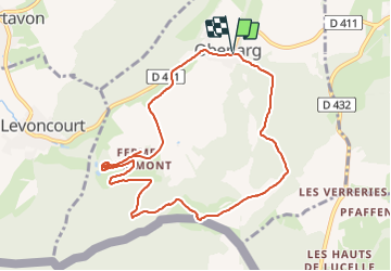
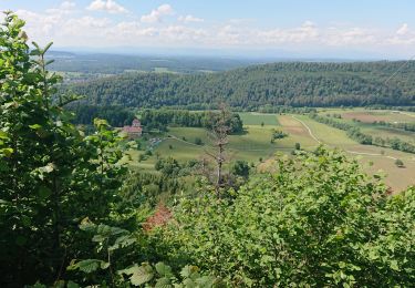
Trail Walking of 9.5 km to be discovered at Grand Est, Haut-Rhin, Oberlarg. This trail is proposed by Bart2015.

Description

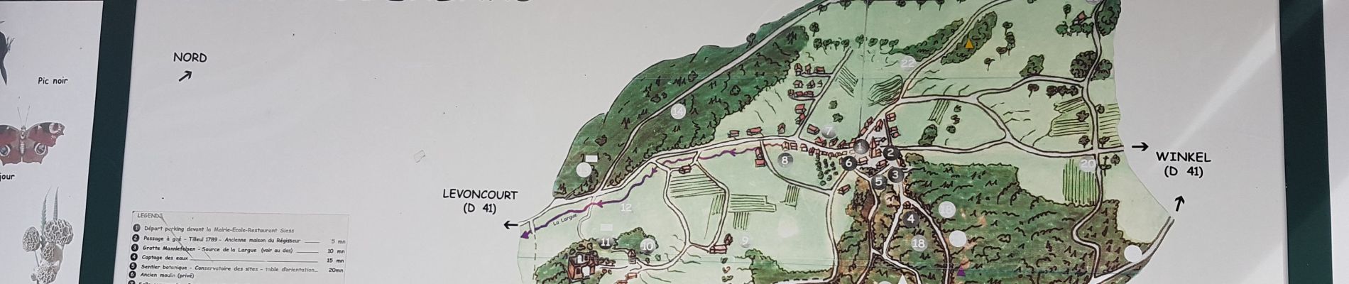
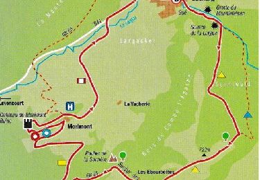
Belle balade pour découvrir les beaux paysages du Sundgau : le gué et l'abri sous roche du Mannlefelsen,  puis après une rude montée la ferme des Ebourbettes qui racontent l’évasion du Général Giraud en 1942. Plus loin, les ruines du Morimont proposent une intéressante leçon d’histoire sur l’adaptation d’un château médiéval aux armes à feu. Ne pas oublier de visiter la vaste galerie, à découvrir après un peu de recherche ...
Bonne rando

Elevation profile

Photos

35 photos in total. Please click on a photo to see them all in the gallery.

Positioning

Country:
France
Region :
Grand Est
Department/Province :
Haut-Rhin
Municipality :
Oberlarg
Location:
Unknown
Start:(UTM)
366918 ; 5257537 (32T) N.

Trails nearby

Trail Walking Levoncourt - Sortie les Copains d'abord.. 24/03/2022 - Photo
Walking
boubou68

Walking

Medium
Levoncourt, Grand Est, Haut-Rhin, France
24 km | 34 km-effort
4h 57min
Yes
Trail On foot Pleigne - Lucelle Douane - Pleigne - Photo
On foot
PRO

On foot

Easy
Pleigne, Jura, District de Delémont, Switzerland
5.3 km | 8 km-effort
1h 48min
No
Trail Walking Oberlarg - oberlag- château de morimont  - Photo
Walking
jcguew

Walking

Easy
Oberlarg, Grand Est, Haut-Rhin, France
9.9 km | 13.7 km-effort
3h 49min
Yes
Trail Walking Oberlarg - Château de Morimont avec Patrice - Photo
Walking
olivier080956

Walking

Medium
Oberlarg, Grand Est, Haut-Rhin, France
6.2 km | 8.1 km-effort
2h 10min
Yes
Trail Walking Oberlarg - 9168282-Oberlarg  : Château de Morimont - Photo
Walking
E.BURCK

Walking

Difficult
Oberlarg, Grand Est, Haut-Rhin, France
9 km | 12.8 km-effort
2h 46min
Yes
Trail Walking Winkel - Winkel-Petit Kohlberg variante - Photo
Walking
JCLUTT

Walking

Very easy
Winkel, Grand Est, Haut-Rhin, France
6.8 km | 8.7 km-effort
1h 58min
Yes
Trail Walking Winkel - Winkel-Petit Kohlberg_wpt_trk - Photo
Walking
JCLUTT

Walking

Very easy
Winkel, Grand Est, Haut-Rhin, France
6.2 km | 8.2 km-effort
1h 51min
Yes
Trail Walking Oberlarg - Oberlag - Photo
Walking
Dan53

Walking

Very easy
Oberlarg, Grand Est, Haut-Rhin, France
6.4 km | 9.4 km-effort
2h 12min
Yes
Trail Walking Bendorf - Bendorf-Vieux Ferrtte-Moernach-Bendorf par Rechenwald - Photo
Walking
patrickbeyrath

Walking

Medium
Bendorf, Grand Est, Haut-Rhin, France
11.3 km | 17.3 km-effort
3h 36min
Yes


Close
My subscriptions