Trail Walking Saint-Julien-en-Beauchêne - Dorbon l'ancienne chartreuse  - Photo
 GILOU440
GILOU440

User

© OpenStreetMap contributors
Length
Length
12.6 km
Max alt
Max alt
1414 m
Uphill gradient
Uphill gradient
572 m
Km-Effort
Km-Effort  
20 km
Min alt
Min alt
916 m
Downhill gradient
Downhill gradient
571 m
Boucle
Boucle
Yes
Creation date :
2021-10-10 08:18:55.803
Updated on :
2021-10-10 15:51:25.211

(0 Reviews)

Walking
Walking
4h15
Difficulty : Medium

Scan this QR Code to open this trail in the SityTrail application

FREE GPS app for hiking

Logo SityTrail SityTrail

IGN / Geographical institutes

Download SityTrail from the App Store Download SityTrail from Google Play

Logo SityTrail SityTrail World

The world is yours!

Download SityTrail from the App Store Download SityTrail from Google Play Download SityTrail on Huawei AppGallery

About

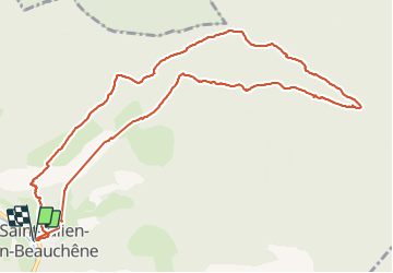
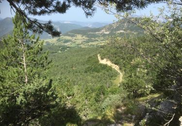
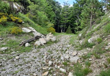
Trail Walking of 12.6 km to be discovered at Provence-Alpes-Côte d'Azur, Hautes-Alpes, Saint-Julien-en-Beauchêne. This trail is proposed by GILOU440.

Description

st Julien en beauchene
l'aupet
col de guillotier
col du pendu
parking
chartreuse
les etroits.
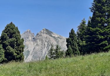
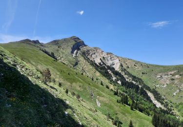
Forte montée pour l'aupet

Elevation profile

Photos

22 photos in total. Please click on a photo to see them all in the gallery.

Positioning

Country:
France
Region :
Provence-Alpes-Côte d'Azur
Department/Province :
Hautes-Alpes
Municipality :
Saint-Julien-en-Beauchêne
Location:
Unknown
Start:(UTM)
714903 ; 4943883 (31T) N.

Trails nearby

Trail On foot Montbrand - 9587037(1) - Photo
On foot
GUIDE+

On foot

Easy
Montbrand, Provence-Alpes-Côte d'Azur, Hautes-Alpes, France
3.5 km | 4.6 km-effort
1h 2min
Yes
Trail Walking Saint-Julien-en-Beauchêne - ST JULIEN EN BEAUCHENE- VAUNIERES - Photo
Walking
BLANCHET

Walking

Medium
(1)
Saint-Julien-en-Beauchêne, Provence-Alpes-Côte d'Azur, Hautes-Alpes, France
9.4 km | 18.4 km-effort
3h 59min
No
Trail Walking Saint-Julien-en-Beauchêne - Montagne de Durbonas - Photo
Walking
Marco05

Walking

Difficult
Saint-Julien-en-Beauchêne, Provence-Alpes-Côte d'Azur, Hautes-Alpes, France
12.3 km | 23 km-effort
5h 16min
Yes
Trail Walking Lus-la-Croix-Haute - Antécime de La Toussière - Photo
Walking
GuyVachet

Walking

Difficult
Lus-la-Croix-Haute, Auvergne-Rhône-Alpes, Drôme, France
8.6 km | 17.4 km-effort
5h 44min
Yes
Trail Walking Saint-Julien-en-Beauchêne - Boucle d'Or Quigouret - Photo
Walking
rigol05

Walking

Very easy
Saint-Julien-en-Beauchêne, Provence-Alpes-Côte d'Azur, Hautes-Alpes, France
9.5 km | 19 km-effort
Unknown
Yes
Trail Walking Saint-Julien-en-Beauchêne - VAUNIERES-LA PARE-03-08-2017 - Photo
Walking
RD78-38

Walking

Medium
Saint-Julien-en-Beauchêne, Provence-Alpes-Côte d'Azur, Hautes-Alpes, France
11.7 km | 21 km-effort
5h 42min
Yes
Trail Walking Montbrand - Crête du Luzet départ de Creyers - Photo
Walking
PapouBertrand

Walking

Difficult
Montbrand, Provence-Alpes-Côte d'Azur, Hautes-Alpes, France
9.7 km | 18 km-effort
5h 8min
Yes
Trail Walking Saint-Julien-en-Beauchêne - 20201013_Quigouret via Montamat le haut - Photo
Walking
PapouBertrand

Walking

Difficult
Saint-Julien-en-Beauchêne, Provence-Alpes-Côte d'Azur, Hautes-Alpes, France
14.6 km | 26 km-effort
6h 30min
Yes
Trail Walking Saint-Julien-en-Beauchêne - la pare - Photo
Walking
gibello

Walking

Medium
Saint-Julien-en-Beauchêne, Provence-Alpes-Côte d'Azur, Hautes-Alpes, France
10.5 km | 20 km-effort
4h 37min
Yes


Close
My subscriptions