Trail Walking Laragne-Montéglin - Tracé_19-OCT-21 164026 - Photo
 rigol05
rigol05

User

© OpenStreetMap contributors
Length
Length
10.3 km
Max alt
Max alt
746 m
Uphill gradient
Uphill gradient
229 m
Km-Effort
Km-Effort  
13.4 km
Min alt
Min alt
567 m
Downhill gradient
Downhill gradient
228 m
Boucle
Boucle
Yes
Creation date :
2021-10-20 08:19:39.461
Updated on :
2021-10-20 08:49:02.613

(0 Reviews)

Walking
Walking
--
Difficulty : Easy

Scan this QR Code to open this trail in the SityTrail application

FREE GPS app for hiking

Logo SityTrail SityTrail

IGN / Geographical institutes

Download SityTrail from the App Store Download SityTrail from Google Play

Logo SityTrail SityTrail World

The world is yours!

Download SityTrail from the App Store Download SityTrail from Google Play Download SityTrail on Huawei AppGallery

About

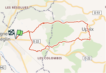
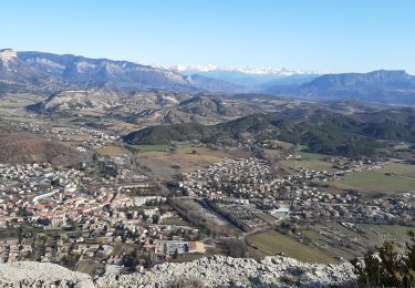
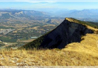
Trail Walking of 10.3 km to be discovered at Provence-Alpes-Côte d'Azur, Hautes-Alpes, Laragne-Montéglin. This trail is proposed by rigol05.

Description

Sortie du 19-10-2021
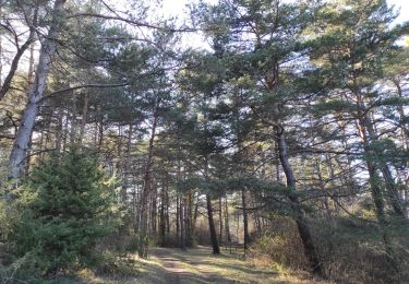
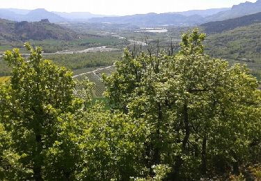
Itinéraire facile et varié, possibilité d'éviter la longue portion de route goudronnée pour remonter vers Upaix en empruntant un bon sentier pentu. Le retour par les crêtes offre quelques moments d'efforts courts mais intenses. Itinéraire bien balisé, au niveau du Brusset quitter la balisage pour aller chercher le sentier passant derrière le cimetière.

Elevation profile

Positioning

Country:
France
Region :
Provence-Alpes-Côte d'Azur
Department/Province :
Hautes-Alpes
Municipality :
Laragne-Montéglin
Location:
Unknown
Start:(UTM)
725888 ; 4910619 (31T) N.

Trails nearby

Trail Walking Val-Buëch-Méouge - SityTrail - PF-Antonaves - Les Gorges de la Méouge - Photo
Walking
raymondfn

Walking

Medium
(1)
Val-Buëch-Méouge, Provence-Alpes-Côte d'Azur, Hautes-Alpes, France
13.3 km | 21 km-effort
4h 22min
Yes
Trail Mountain bike Laragne-Montéglin - Laragne 2008 - Photo
Mountain bike
tracegps

Mountain bike

Difficult
(1)
Laragne-Montéglin, Provence-Alpes-Côte d'Azur, Hautes-Alpes, France
35 km | 47 km-effort
3h 0min
No
Trail Walking Lazer - Le lac de Lazer par La Chapelle StJean - Photo
Walking
babouille

Walking

Medium
Lazer, Provence-Alpes-Côte d'Azur, Hautes-Alpes, France
6.5 km | 7.4 km-effort
1h 40min
Yes
Trail sport Mison - Du lac de MISON à celui du Poet par les colombettes  - Photo
sport
babouille

sport

Very easy
Mison, Provence-Alpes-Côte d'Azur, Alpes-de-Haute-Provence, France
5.7 km | 6.8 km-effort
Unknown
Yes
Trail On foot Mison - Tour du château de MISON par le Buech  - Photo
On foot
babouille

On foot

Easy
Mison, Provence-Alpes-Côte d'Azur, Alpes-de-Haute-Provence, France
5.9 km | 7.8 km-effort
1h 46min
Yes
Trail Walking Laragne-Montéglin - Vieil Arzellier/Vieil Eyguians.21/02/21. - Photo
Walking
Dervalmarc

Walking

Easy
Laragne-Montéglin, Provence-Alpes-Côte d'Azur, Hautes-Alpes, France
3.5 km | 4.7 km-effort
59min
No
Trail Walking Val-Buëch-Méouge - CHATEAU NEUF DE CHABRE 05 . Piloubeau , les cretes de Chabre o s - Photo
Walking
RobinMicheline

Walking

Difficult
Val-Buëch-Méouge, Provence-Alpes-Côte d'Azur, Hautes-Alpes, France
14.8 km | 24 km-effort
6h 11min
Yes
Trail Walking Val-Buëch-Méouge - R31   La Montagne de Chabre - Photo
Walking
GUIDE+

Walking

Very easy
(1)
Val-Buëch-Méouge, Provence-Alpes-Côte d'Azur, Hautes-Alpes, France
2.8 km | 4.6 km-effort
1h 10min
Yes
Trail Walking Val-Buëch-Méouge - roche de baume rousse - Photo
Walking
margotte

Walking

Medium
Val-Buëch-Méouge, Provence-Alpes-Côte d'Azur, Hautes-Alpes, France
9.3 km | 14.1 km-effort
3h 37min
Yes


Close
My subscriptions