Trail Walking Saint-Amand-les-Eaux - notre dame d'amour(NDA), propose par VDN - Photo

notre dame d'amour(NDA), propose par VDN

 papiou
papiou

User

© OpenStreetMap contributors
Length
Length
9.7 km
Max alt
Max alt
30 m
Uphill gradient
Uphill gradient
64 m
Km-Effort
Km-Effort  
10.6 km
Min alt
Min alt
12 m
Downhill gradient
Downhill gradient
61 m
Boucle
Boucle
Yes
Creation date :
2022-01-14 12:52:49.444
Updated on :
2022-01-14 16:13:22.92

(0 Reviews)

Walking
Walking
2h16
Difficulty : Medium

Scan this QR Code to open this trail in the SityTrail application

FREE GPS app for hiking

Logo SityTrail SityTrail

IGN / Geographical institutes

Download SityTrail from the App Store Download SityTrail from Google Play

Logo SityTrail SityTrail World

The world is yours!

Download SityTrail from the App Store Download SityTrail from Google Play Download SityTrail on Huawei AppGallery

About

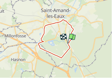
Trail Walking of 9.7 km to be discovered at Hauts-de-France, Nord, Saint-Amand-les-Eaux. This trail is proposed by papiou.

Description

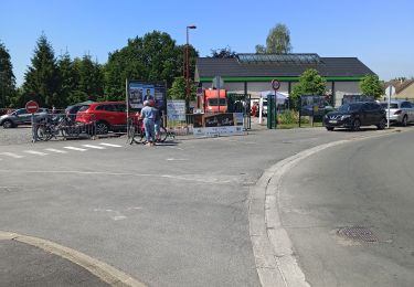
RDV parking NDA ou blockhaus. face à la route partir à gauche pour rejoindre dreve NDA puis 800m plus loin prendre à droite dreve de la scarpe, longueur  2km, au CD-ROM à droite et 500m plus loin prendre à gauche pour rejoindre la scarpe, sur la berge rejoindre piscine et par la droite en traversant parking Pasino rejoindre la route menant à la place du Mtn des bruyères et ensuite rejoindre le point de départ

Elevation profile

Photos

Positioning

Country:
France
Region :
Hauts-de-France
Department/Province :
Nord
Municipality :
Saint-Amand-les-Eaux
Location:
Unknown
Start:(UTM)
531392 ; 5586261 (31U) N.

Trails nearby

Trail Walking Raismes - Circuit du Terril de Sabatier - Photo
Walking
corsinou

Walking

Easy
(1)
Raismes, Hauts-de-France, Nord, France
13 km | 14.9 km-effort
2h 34min
Yes
Trail Walking Saint-Amand-les-Eaux - terril vicoigne - Photo
Walking
papiou

Walking

Easy
Saint-Amand-les-Eaux, Hauts-de-France, Nord, France
8.7 km | 9.7 km-effort
2h 0min
Yes
Trail Walking Raismes - variante de la course des terrils - Photo
Walking
papiou

Walking

Medium
(1)
Raismes, Hauts-de-France, Nord, France
8.8 km | 10 km-effort
2h 10min
Yes
Trail Walking Wallers - Mare goraux - Photo
Walking
xcreator

Walking

Medium
Wallers, Hauts-de-France, Nord, France
6.8 km | 7.5 km-effort
1h 32min
Yes
Trail Walking Nivelle - Nivelle- circuit Nivelle-Mortagne-Chateau l'abbaye - Photo
Walking
papiou

Walking

Easy
(1)
Nivelle, Hauts-de-France, Nord, France
11.5 km | 12.2 km-effort
2h 30min
Yes
Trail Walking Wallers - tour d'Hasnon par forêt et ruisseau - Photo
Walking
papiou

Walking

Easy
Wallers, Hauts-de-France, Nord, France
9.8 km | 10.6 km-effort
2h 8min
Yes
Trail Walking Saint-Amand-les-Eaux - Mesnil, version plus longue - Photo
Walking
papiou

Walking

Easy
Saint-Amand-les-Eaux, Hauts-de-France, Nord, France
9.9 km | 11.1 km-effort
2h 2min
Yes
Trail Walking Saint-Amand-les-Eaux - Mesnil. st Amand - Photo
Walking
papiou

Walking

Easy
Saint-Amand-les-Eaux, Hauts-de-France, Nord, France
8.5 km | 9.6 km-effort
1h 28min
Yes
Trail Walking Wallers - forêt de Raismes et mare à Gorriaux - Photo
Walking
Templeuveenmarche

Walking

Medium
(2)
Wallers, Hauts-de-France, Nord, France
10.6 km | 11.7 km-effort
2h 35min
Yes


Close
My subscriptions