Trail Car Rochejean - ZR17 Rochejean - Photo
 i20
i20

User

© OpenStreetMap contributors
Length
Length
10.6 km
Max alt
Max alt
1012 m
Uphill gradient
Uphill gradient
243 m
Km-Effort
Km-Effort  
13.7 km
Min alt
Min alt
868 m
Downhill gradient
Downhill gradient
199 m
Boucle
Boucle
No
Creation date :
2022-02-14 22:12:30.881
Updated on :
2022-02-14 22:13:20.222

(0 Reviews)

Car
Car
--
Difficulty : Difficult

Scan this QR Code to open this trail in the SityTrail application

FREE GPS app for hiking

Logo SityTrail SityTrail

IGN / Geographical institutes

Download SityTrail from the App Store Download SityTrail from Google Play

Logo SityTrail SityTrail World

The world is yours!

Download SityTrail from the App Store Download SityTrail from Google Play Download SityTrail on Huawei AppGallery

About

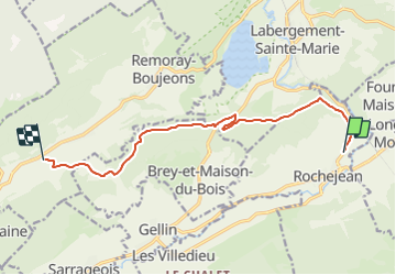
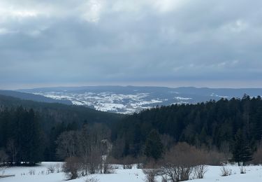
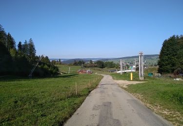
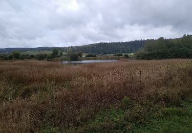
Trail Car of 10.6 km to be discovered at Bourgogne-Franche-Comté, Doubs, Rochejean. This trail is proposed by i20.

Elevation profile

Positioning

Country:
France
Region :
Bourgogne-Franche-Comté
Department/Province :
Doubs
Municipality :
Rochejean
Location:
Unknown
Start:(UTM)
293532 ; 5180966 (32T) N.

Trails nearby

Trail Walking Remoray-Boujeons - Remoray-Boujeons - Le Belvédère des deux Lacs - Photo
Walking
nicolibris

Walking

Difficult
(1)
Remoray-Boujeons, Bourgogne-Franche-Comté, Doubs, France
10.4 km | 13.8 km-effort
2h 58min
Yes
Trail Walking Remoray-Boujeons - Le Belvédère des 2 lacs - Doubs - Photo
Walking
tracegps

Walking

Difficult
(1)
Remoray-Boujeons, Bourgogne-Franche-Comté, Doubs, France
13.7 km | 19 km-effort
4h 0min
Yes
Trail Walking Métabief - GTJ  Metabief - Pontarlier - Photo
Walking
svp59

Walking

Medium
(1)
Métabief, Bourgogne-Franche-Comté, Doubs, France
25 km | 35 km-effort
7h 17min
No
Trail Walking Saint-Antoine - Boucle du fort St Antoine  - Photo
Walking
mallovon

Walking

Medium
Saint-Antoine, Bourgogne-Franche-Comté, Doubs, France
4.8 km | 6.2 km-effort
1h 25min
Yes
Trail Walking Rochejean - Mont d'or  - Photo
Walking
eltonnermou

Walking

Easy
Rochejean, Bourgogne-Franche-Comté, Doubs, France
11.9 km | 17.5 km-effort
4h 53min
Yes
Trail Snowshoes Métabief - Les hauteurs de Metabief - Photo
Snowshoes
zefreefly

Snowshoes

Medium
Métabief, Bourgogne-Franche-Comté, Doubs, France
15.5 km | 23 km-effort
3h 51min
Yes
Trail Walking Métabief - Mont d'Or - Photo
Walking
helmut68

Walking

Medium
Métabief, Bourgogne-Franche-Comté, Doubs, France
13.5 km | 21 km-effort
3h 39min
No
Trail Walking Labergement-Sainte-Marie - Lac de Remoray - Photo
Walking
helmut68

Walking

Easy
Labergement-Sainte-Marie, Bourgogne-Franche-Comté, Doubs, France
14.5 km | 18.4 km-effort
3h 25min
No
Trail Snowshoes Longevilles-Mont-d'Or - Les Longevilles Mont D'Or CAF - Photo
Snowshoes
TRIMAILLE

Snowshoes

Medium
(1)
Longevilles-Mont-d'Or, Bourgogne-Franche-Comté, Doubs, France
8.4 km | 13 km-effort
8h 27min
Yes


Close
My subscriptions