Trail Walking Saint-Paul-sur-Ubaye - Saint paul sur Ubaye - Photo
© OpenStreetMap contributors
Length
Length
13.1 km
Max alt
Max alt
1961 m
Uphill gradient
Uphill gradient
600 m
Km-Effort
Km-Effort  
21 km
Min alt
Min alt
1432 m
Downhill gradient
Downhill gradient
601 m
Boucle
Boucle
Yes
Creation date :
2019-04-24 16:28:21.689
Updated on :
2019-04-24 16:28:21.736

(0 Reviews)

Walking
Walking
12m
Difficulty : Easy

Scan this QR Code to open this trail in the SityTrail application

FREE GPS app for hiking

Logo SityTrail SityTrail

IGN / Geographical institutes

Download SityTrail from the App Store Download SityTrail from Google Play

Logo SityTrail SityTrail World

The world is yours!

Download SityTrail from the App Store Download SityTrail from Google Play Download SityTrail on Huawei AppGallery

About

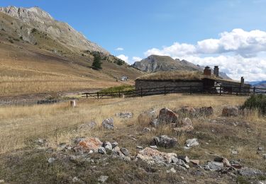
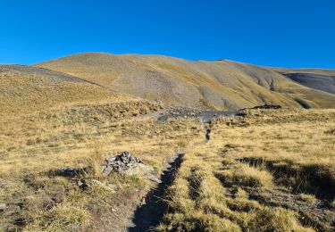
Trail Walking of 13.1 km to be discovered at Provence-Alpes-Côte d'Azur, Alpes-de-Haute-Provence, Saint-Paul-sur-Ubaye. This trail is proposed by emileverschueren.

Description

Localité de départSaint-Paul-sur-UbayeLocalité d'arrivéeSaint-Paul-sur-Ubaye13.136kmAltitude min.1437mAltitude max.1946mDénivelé Tot.  566mDénivelé Tot. --568mActivitéMarcheDifficultéBasseType de solSentierType de parcoursNon officielParcours baliséNon

Elevation profile

Positioning

Country:
France
Region :
Provence-Alpes-Côte d'Azur
Department/Province :
Alpes-de-Haute-Provence
Municipality :
Saint-Paul-sur-Ubaye
Location:
Unknown
Start:(UTM)
321519 ; 4931634 (32T) N.

Trails nearby

Trail Walking Val-d'Oronaye - Saint Ours - Plateau de Mallemort - Photo
Walking
Coqorico

Walking

Very easy
(2)
Val-d'Oronaye, Provence-Alpes-Côte d'Azur, Alpes-de-Haute-Provence, France
10.4 km | 15.4 km-effort
1h 49min
Yes
Trail Walking Vars - boucle col de Vars  - Photo
Walking
marmotte83

Walking

Easy
(2)
Vars, Provence-Alpes-Côte d'Azur, Hautes-Alpes, France
4.5 km | 6.1 km-effort
2h 39min
Yes
Trail Walking Val-d'Oronaye - Fort de Rochecroix PR43 - Photo
Walking
ged94

Walking

Medium
(1)
Val-d'Oronaye, Provence-Alpes-Côte d'Azur, Alpes-de-Haute-Provence, France
10.1 km | 18.2 km-effort
6h 13min
No
Trail Walking Vars - Tête de Paneyron - Col de Vars - Photo
Walking
tracegps

Walking

Difficult
(1)
Vars, Provence-Alpes-Côte d'Azur, Hautes-Alpes, France
10 km | 19 km-effort
3h 0min
Yes
Trail Other activity Saint-Paul-sur-Ubaye - massour  - Photo
Other activity
Sandrine1

Other activity

Medium
(1)
Saint-Paul-sur-Ubaye, Provence-Alpes-Côte d'Azur, Alpes-de-Haute-Provence, France
6.1 km | 19.3 km-effort
3h 19min
No
Trail Walking Saint-Paul-sur-Ubaye - Lac des 9 couleurs - Photo
Walking
andre06130

Walking

Medium
(1)
Saint-Paul-sur-Ubaye, Provence-Alpes-Côte d'Azur, Alpes-de-Haute-Provence, France
17.4 km | 31 km-effort
6h 15min
Yes
Trail Walking Val-d'Oronaye - fort roche la croix - Photo
Walking
rvmp

Walking

Easy
(1)
Val-d'Oronaye, Provence-Alpes-Côte d'Azur, Alpes-de-Haute-Provence, France
13.6 km | 23 km-effort
7h 11min
Yes
Trail Walking Vars - La MORTICE ( nord et sud) depuis col de Vars - Photo
Walking
tchoua

Walking

Very difficult
Vars, Provence-Alpes-Côte d'Azur, Hautes-Alpes, France
22 km | 44 km-effort
6h 41min
Yes
Trail Walking Saint-Paul-sur-Ubaye - pointe de l'Eyssina  - Photo
Walking
orsel

Walking

Medium
Saint-Paul-sur-Ubaye, Provence-Alpes-Côte d'Azur, Alpes-de-Haute-Provence, France
8.7 km | 18 km-effort
6h 54min
No


Close
My subscriptions