Trail Walking Villeneuve-Saint-Georges - De Villeneuve St Georges à Boissy Saint Léger - Photo

De Villeneuve St Georges à Boissy Saint Léger

 tracegps
tracegps

User

© OpenStreetMap contributors
Length
Length
12.3 km
Max alt
Max alt
122 m
Uphill gradient
Uphill gradient
143 m
Km-Effort
Km-Effort  
14.1 km
Min alt
Min alt
36 m
Downhill gradient
Downhill gradient
123 m
Boucle
Boucle
No
Creation date :
2014-12-10 00:00:00.0
Updated on :
2014-12-10 00:00:00.0

(0 Reviews)

Walking
Walking
3h00
Difficulty : Difficult

Scan this QR Code to open this trail in the SityTrail application

FREE GPS app for hiking

Logo SityTrail SityTrail

IGN / Geographical institutes

Download SityTrail from the App Store Download SityTrail from Google Play

Logo SityTrail SityTrail World

The world is yours!

Download SityTrail from the App Store Download SityTrail from Google Play Download SityTrail on Huawei AppGallery

About

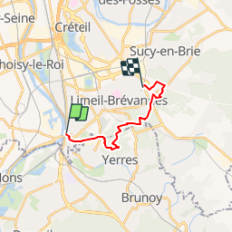
Trail Walking of 12.3 km to be discovered at Ile-de-France, Val-de-Marne, Villeneuve-Saint-Georges. This trail is proposed by tracegps.

Description

Une balade qui alterne paysages urbains et grands passages forestiers. Le circuit est de gare à gare.

Elevation profile

Photos

Positioning

Country:
France
Region :
Ile-de-France
Department/Province :
Val-de-Marne
Municipality :
Villeneuve-Saint-Georges
Location:
Unknown
Start:(UTM)
459334 ; 5397554 (31U) N.

Trails nearby

Trail Walking Juvisy-sur-Orge - GRP CV-IDF 2023 - Photo
Walking
clalaur

Walking

Difficult
(1)
Juvisy-sur-Orge, Ile-de-France, Essonne, France
14.8 km | 17 km-effort
3h 52min
No
Trail Walking Yerres - BM Foret Regionale de Grobois 10km - Photo
Walking
GUIDE
jeanmarcMasson

Walking

Medium
(1)
Yerres, Ile-de-France, Essonne, France
10.4 km | 11 km-effort
2h 30min
Yes
Trail Walking Yerres - BM Foret Regionale Grosbois 10km - Photo
Walking
GUIDE
jeanmarcMasson

Walking

Medium
(1)
Yerres, Ile-de-France, Essonne, France
9.8 km | 10.5 km-effort
2h 23min
Yes
Trail On foot Brunoy - L 39 Brunoy, les bords de l'Yerres - Photo
On foot

On foot

Very easy
(4)
Brunoy, Ile-de-France, Essonne, France
5.4 km | 6.1 km-effort
1h 49min
Yes
Trail Walking Montgeron - J 38 Montgeron la Pelouse, forêt de Sénart - Photo
Walking

Walking

Medium
(3)
Montgeron, Ile-de-France, Essonne, France
12.3 km | 13.2 km-effort
3h 9min
Yes
Trail Walking Yerres - J 43  Yerres Parc Caillebotte, île des Prévôts - Photo
Walking

Walking

Medium
(2)
Yerres, Ile-de-France, Essonne, France
11.4 km | 13.1 km-effort
2h 59min
Yes
Trail Walking Draveil - Port aux Cerises - Ablon 21 km - Photo
Walking
GUIDE
jeanmarcMasson

Walking

Very difficult
(1)
Draveil, Ile-de-France, Essonne, France
22 km | 25 km-effort
4h 51min
Yes
Trail Walking Yerres - Boucle Yerres - Réveillon- Bois de la Grange - 12 km - Photo
Walking
GUIDE
jeanmarcMasson

Walking

Difficult
(1)
Yerres, Ile-de-France, Essonne, France
12.1 km | 14 km-effort
3h 11min
Yes
Trail Walking Yerres - SityTrail - Téléthon.2022.Circuit A - Photo
Walking
GUIDE
jeanmarcMasson

Walking

Medium
(2)
Yerres, Ile-de-France, Essonne, France
5.5 km | 6.1 km-effort
1h 23min
Yes


Close
My subscriptions