Trail Mountain bike Font-Romeu-Odeillo-Via -  FFC Capcir Haut Conflent Circuit 34 Pic des Mauroux  - Photo

FFC Capcir Haut Conflent Circuit 34 Pic des Mauroux

 tracegps
tracegps

User

© OpenStreetMap contributors
Length
Length
19.8 km
Max alt
Max alt
2135 m
Uphill gradient
Uphill gradient
525 m
Km-Effort
Km-Effort  
27 km
Min alt
Min alt
1757 m
Downhill gradient
Downhill gradient
527 m
Boucle
Boucle
Yes
Creation date :
2014-12-10 00:00:00.0
Updated on :
2014-12-10 00:00:00.0

(2 Reviews)

Mountain bike
Mountain bike
3h00
Difficulty : Difficult

Scan this QR Code to open this trail in the SityTrail application

FREE GPS app for hiking

Logo SityTrail SityTrail

IGN / Geographical institutes

Download SityTrail from the App Store Download SityTrail from Google Play

Logo SityTrail SityTrail World

The world is yours!

Download SityTrail from the App Store Download SityTrail from Google Play Download SityTrail on Huawei AppGallery

About

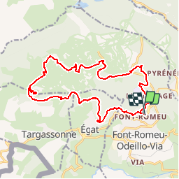
Trail Mountain bike of 19.8 km to be discovered at Occitania, Pyrénées-Orientales, Font-Romeu-Odeillo-Via. This trail is proposed by tracegps.

Description

Il s'agit de l' ancien circuit n°11 - maintenant le n° 34 avec certains changements qui n'étaient pas mis à jour par la FFC. Circuit très roulant jusqu’au Pic de Mauroux puis en descente un peu plus difficile techniquement.

Elevation profile

Photos

Positioning

Country:
France
Region :
Occitania
Department/Province :
Pyrénées-Orientales
Municipality :
Font-Romeu-Odeillo-Via
Location:
Unknown
Start:(UTM)
421390 ; 4706432 (31T) N.

Comments

Please log in to post a review or rate the element


les angles 4


Trails nearby

Trail Walking Font-Romeu-Odeillo-Via - Coll del Pam lac des  Bouillouses - Photo
Walking
jcmartin

Walking

Medium
(2)
Font-Romeu-Odeillo-Via, Occitania, Pyrénées-Orientales, France
13.3 km | 19.3 km-effort
4h 10min
Yes
Trail Walking Eyne - Eyne,col de Nuria,pic d'Eyne,Torre d'Eyne,Eyne. - Photo
Walking
Machaon6

Walking

Very difficult
(1)
Eyne, Occitania, Pyrénées-Orientales, France
24 km | 43 km-effort
8h 44min
Yes
Trail Snowshoes Font-Romeu-Odeillo-Via - pic dels moros - Photo
Snowshoes
jpipacific

Snowshoes

Medium
(1)
Font-Romeu-Odeillo-Via, Occitania, Pyrénées-Orientales, France
12.6 km | 19.4 km-effort
4h 46min
Yes
Trail Walking Font-Romeu-Odeillo-Via - Font Romeu Egat - Photo
Walking
crijack

Walking

Medium
(2)
Font-Romeu-Odeillo-Via, Occitania, Pyrénées-Orientales, France
2.5 km | 3.4 km-effort
44min
Yes
Trail Snowshoes Font-Romeu-Odeillo-Via - Pic dels Moros avec Pierre - Photo
Snowshoes
jpipacific

Snowshoes

Medium
(1)
Font-Romeu-Odeillo-Via, Occitania, Pyrénées-Orientales, France
10.5 km | 15.9 km-effort
4h 4min
Yes
Trail Walking Égat - Egat  Puig  Moro - Photo
Walking
ohelluin

Walking

Medium
(1)
Égat, Occitania, Pyrénées-Orientales, France
13.4 km | 19.3 km-effort
4h 51min
Yes
Trail Walking Égat - La croix d'Egat - Photo
Walking
ochamley

Walking

Easy
(1)
Égat, Occitania, Pyrénées-Orientales, France
7.1 km | 10.4 km-effort
2h 2min
Yes
Trail Walking Égat - Le Pic dels Moros - Photo
Walking
tracegps

Walking

Difficult
(2)
Égat, Occitania, Pyrénées-Orientales, France
12.1 km | 18.8 km-effort
5h 30min
Yes
Trail Walking Eyne - Le Cambre d'Ase - Photo
Walking
tracegps

Walking

Difficult
(1)
Eyne, Occitania, Pyrénées-Orientales, France
8.9 km | 22 km-effort
4h 0min
Yes


Close
My subscriptions