Trail Running Eaux-Bonnes -  La Montagne Verte - Eaux Bonnes - Photo

La Montagne Verte - Eaux Bonnes

 tracegps
tracegps

User

© OpenStreetMap contributors
Length
Length
11.1 km
Max alt
Max alt
1194 m
Uphill gradient
Uphill gradient
553 m
Km-Effort
Km-Effort  
18.4 km
Min alt
Min alt
635 m
Downhill gradient
Downhill gradient
553 m
Boucle
Boucle
Yes
Creation date :
2014-12-10 00:00:00.0
Updated on :
2014-12-10 00:00:00.0

(0 Reviews)

Running
Running
1h45
Difficulty : Difficult

Scan this QR Code to open this trail in the SityTrail application

FREE GPS app for hiking

Logo SityTrail SityTrail

IGN / Geographical institutes

Download SityTrail from the App Store Download SityTrail from Google Play

Logo SityTrail SityTrail World

The world is yours!

Download SityTrail from the App Store Download SityTrail from Google Play Download SityTrail on Huawei AppGallery

About

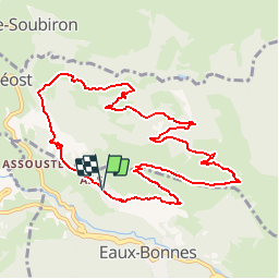
Trail Running of 11.1 km to be discovered at New Aquitaine, Pyrénées-Atlantiques, Eaux-Bonnes. This trail is proposed by tracegps.

Description

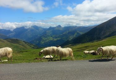
Départ: Aas, début du chemin de Pleysse. Elle porte bien son nom la Montagne Verte, ses pâturages restent verts même en été. Ce belvédère naturel offre un panorama sur la vallée des Eaux-Bonnes et le Pic du Ger. Téléchargez la fiche du circuit n°16 sur le site de la vallée d'Ossau. Crédit photos : Autres photos de janmorel .

Elevation profile

Photos

Positioning

Country:
France
Region :
New Aquitaine
Department/Province :
Pyrénées-Atlantiques
Municipality :
Eaux-Bonnes
Location:
Unknown
Start:(UTM)
712024 ; 4761888 (30T) N.

Trails nearby

Trail Walking Béost - Behost - Photo
Walking
swp648

Walking

Easy
(1)
Béost, New Aquitaine, Pyrénées-Atlantiques, France
6 km | 9.9 km-effort
2h 59min
Yes
Trail Walking Laruns - LARUNS le tour du valentin G3
Walking
GUIDE
marmotte65

Walking

Difficult
Laruns, New Aquitaine, Pyrénées-Atlantiques, France
8.2 km | 12.9 km-effort
2h 56min
Yes
Trail On foot Eaux-Bonnes - La promenade horizontale - Photo
On foot
PRO

On foot

Easy
Eaux-Bonnes, New Aquitaine, Pyrénées-Atlantiques, France
3.5 km | 5.3 km-effort
1h 12min
Yes
Trail On foot Eaux-Bonnes - Les thermes - Photo
On foot
PRO

On foot

Easy
Eaux-Bonnes, New Aquitaine, Pyrénées-Atlantiques, France
3.6 km | 5.9 km-effort
1h 20min
Yes
Trail On foot Laruns - L'eau - Photo
On foot
PRO

On foot

Easy
Laruns, New Aquitaine, Pyrénées-Atlantiques, France
4.8 km | 5.9 km-effort
1h 20min
Yes
Trail On foot Béost - Les crêtes d’Andreyt - Photo
On foot
PRO

On foot

Easy
Béost, New Aquitaine, Pyrénées-Atlantiques, France
9.6 km | 14.7 km-effort
3h 20min
Yes
Trail On foot Eaux-Bonnes - La montagne verte - Photo
On foot
PRO

On foot

Easy
Eaux-Bonnes, New Aquitaine, Pyrénées-Atlantiques, France
10.4 km | 17.8 km-effort
4h 2min
Yes
Trail On foot Louvie-Soubiron - Les carrières - Photo
On foot
PRO

On foot

Easy
Louvie-Soubiron, New Aquitaine, Pyrénées-Atlantiques, France
3.4 km | 7 km-effort
1h 35min
Yes
Trail On foot Béost - La promenade des trois villages - Photo
On foot
PRO

On foot

Easy
Béost, New Aquitaine, Pyrénées-Atlantiques, France
5.1 km | 8.6 km-effort
1h 56min
Yes


Close
My subscriptions