Trail Walking Auriol - Autour d’Auriol - Photo
 Pacekall
Pacekall

User

© OpenStreetMap contributors
Length
Length
9.5 km
Max alt
Max alt
424 m
Uphill gradient
Uphill gradient
240 m
Km-Effort
Km-Effort  
12.7 km
Min alt
Min alt
198 m
Downhill gradient
Downhill gradient
239 m
Boucle
Boucle
Yes
Creation date :
2022-05-04 13:41:27.0
Updated on :
2022-05-04 15:41:31.329

(1 Reviews)

Walking
Walking
1h59
Difficulty : Easy

Scan this QR Code to open this trail in the SityTrail application

FREE GPS app for hiking

Logo SityTrail SityTrail

IGN / Geographical institutes

Download SityTrail from the App Store Download SityTrail from Google Play

Logo SityTrail SityTrail World

The world is yours!

Download SityTrail from the App Store Download SityTrail from Google Play Download SityTrail on Huawei AppGallery

About

Trail Walking of 9.5 km to be discovered at Provence-Alpes-Côte d'Azur, Bouches-du-Rhône, Auriol. This trail is proposed by Pacekall.

Description

Petite balade autour d’Auriol. Quelques points de vues et chemins sous les sapins avant la descente sur le retour. Bon pour un petit décrassage hebdomadaire.

Elevation profile

Positioning

Country:
France
Region :
Provence-Alpes-Côte d'Azur
Department/Province :
Bouches-du-Rhône
Municipality :
Auriol
Location:
Unknown
Start:(UTM)
713516 ; 4805308 (31T) N.

Comments

Please log in to post a review or rate the element


Trails nearby

Trail Mountain bike Trets - les contreforts du mont Olympe - Photo
Mountain bike
GUIDE
amiral13

Mountain bike

Easy
(1)
Trets, Provence-Alpes-Côte d'Azur, Bouches-du-Rhône, France
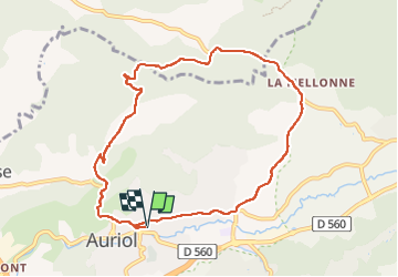
11.8 km | 15.5 km-effort
2h 52min
Yes
Trail Walking Auriol - la crete des infernets - Photo
Walking
Coryphene

Walking

Difficult
(1)
Auriol, Provence-Alpes-Côte d'Azur, Bouches-du-Rhône, France
8.6 km | 14 km-effort
3h 22min
Yes
Trail On foot Auriol - Les moulins - Photo
On foot
PRO

On foot

Easy
Auriol, Provence-Alpes-Côte d'Azur, Bouches-du-Rhône, France
3.7 km | 4.2 km-effort
57min
Yes
Trail Walking Auriol - le ravin des Encanaux - Photo
Walking
GUIDE
amiral13

Walking

Difficult
Auriol, Provence-Alpes-Côte d'Azur, Bouches-du-Rhône, France
7.3 km | 12.2 km-effort
3h 10min
Yes
Trail Walking Roquevaire - Garlaban au départ de Lascours  - Photo
Walking
GUIDE
nadinebondoux

Walking

Difficult
Roquevaire, Provence-Alpes-Côte d'Azur, Bouches-du-Rhône, France
15.6 km | 26 km-effort
6h 1min
Yes
Trail Walking Roquevaire - le mont du marseillais par le grand Vallon - Photo
Walking
GUIDE
amiral13

Walking

Difficult
Roquevaire, Provence-Alpes-Côte d'Azur, Bouches-du-Rhône, France
9.9 km | 15.9 km-effort
4h 50min
Yes
Trail Walking Roquevaire - Le Garlaban par le Grand Vallon - Photo
Walking
ARPF

Walking

Difficult
(1)
Roquevaire, Provence-Alpes-Côte d'Azur, Bouches-du-Rhône, France
10.1 km | 18.7 km-effort
3h 49min
Yes
Trail Walking Roquevaire - Marmittes du grand vallon - Photo
Walking
Equedreu

Walking

Easy
(1)
Roquevaire, Provence-Alpes-Côte d'Azur, Bouches-du-Rhône, France
8.5 km | 14.4 km-effort
2h 24min
Yes
Trail Walking Auriol - les Encanaux  - Photo
Walking
cousam

Walking

Difficult
Auriol, Provence-Alpes-Côte d'Azur, Bouches-du-Rhône, France
7.1 km | 11 km-effort
2h 14min
Yes


Close
My subscriptions