Trail Mountain bike Anhée - Randonnée du 05/05/2022 à 13:30 - Photo

Randonnée du 05/05/2022 à 13:30

© OpenStreetMap contributors
Length
Length
27 km
Max alt
Max alt
249 m
Uphill gradient
Uphill gradient
477 m
Km-Effort
Km-Effort  
34 km
Min alt
Min alt
84 m
Downhill gradient
Downhill gradient
477 m
Boucle
Boucle
Yes
Creation date :
2022-05-05 12:28:25.916
Updated on :
2022-07-07 15:05:19.284

(0 Reviews)

Mountain bike
Mountain bike
2h00
Difficulty : Difficult

Scan this QR Code to open this trail in the SityTrail application

FREE GPS app for hiking

Logo SityTrail SityTrail

IGN / Geographical institutes

Download SityTrail from the App Store Download SityTrail from Google Play

Logo SityTrail SityTrail World

The world is yours!

Download SityTrail from the App Store Download SityTrail from Google Play Download SityTrail on Huawei AppGallery

About

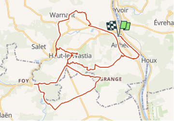
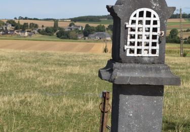
Trail Mountain bike of 27 km to be discovered at Wallonia, Namur, Anhée. This trail is proposed by Romain François.

Description

Crazy Trott vous propose ce parcour en trotinette électrique tout terrain de 27km qui passera par les magnifiques paysages des villages d'Anhée, Warnant, Haut-le-Wastia et Falaen.

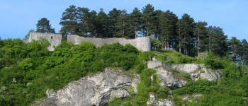
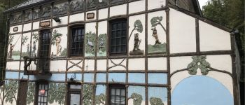
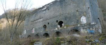
Sur votre route, vous pourrez admirer de magnifiques site du patrimoine de cette magnifique région.

Elevation profile

Photos

Points of interest

Point of interest Anhée - Crazy Trott - Photo
Romain François
ANHÉE 
Point of interest Anhée - Bunker - Photo
Romain François
ANHÉE 
Point of interest Yvoir - Les Ruines de la forteresse de Poilvache - Photo
Romain François
Point of interest Anhée - Escargotière de Warnant - Photo
Romain François
Point of interest Anhée - La Villa des Lapins - Photo
Romain François
Point of interest Anhée - Les Draisines de la Molignée - Photo
Romain François
Point of interest Anhée - Four à chaux - Photo
Romain François
Point of interest Anhée - Point de vue Haut-le-Wastia - Photo
Romain François
Point of interest Anhée - Musée souvenir mai 1940 - Photo
Romain François
Point of interest Onhaye - Les Ruines du château de Montaigle - Photo
Romain François

Positioning

Country:
Belgium
Region :
Wallonia
Department/Province :
Namur
Municipality :
Anhée
Location:
Unknown
Start:(UTM)
633574 ; 5575226 (31U) N.

Trails nearby

Trail Walking Yvoir - RB-Na-21-Terres seigneuriales et carrières de la vallée du Bocq - Photo
Walking
PRO

Walking

Very difficult
(6)
Yvoir, Wallonia, Namur, Belgium
22 km | 30 km-effort
6h 51min
Yes
Trail Walking Yvoir - RB-Na-03 Forteresses, citadelle et abbaye mosanes - Photo
Walking
PRO

Walking

Difficult
(11)
Yvoir, Wallonia, Namur, Belgium
22 km | 30 km-effort
7h 1min
Yes
Trail Walking Yvoir - GG2-Na-38_Godinne-Dinant (2021-11-04) - Photo
Walking
PRO

Walking

Very difficult
(6)
Yvoir, Wallonia, Namur, Belgium
19.5 km | 27 km-effort
6h 13min
No
Trail Walking Anhée - RF-Na-05 Annevoie, côté Jardins_Grande-boucle - Photo
Walking
PRO

Walking

Medium
(11)
Anhée, Wallonia, Namur, Belgium
11.3 km | 14.5 km-effort
3h 6min
Yes
Trail Walking Anhée - RF-Na-05 Annevoie, côté Jardins_Petite-boucle - Photo
Walking
PRO

Walking

Easy
(7)
Anhée, Wallonia, Namur, Belgium
7.4 km | 10 km-effort
2h 7min
Yes
Trail Walking Onhaye - RB-Na-C2-Sommière-Complet_20,4km - Photo
Walking
PRO

Walking

Very difficult
(2)
Onhaye, Wallonia, Namur, Belgium
20 km | 25 km-effort
5h 25min
Yes
Trail Walking Yvoir - RB-Na-21-raccourci-Terres seigneuriales et carrières de la vallée du Bocq - Photo
Walking
PRO

Walking

Very difficult
(3)
Yvoir, Wallonia, Namur, Belgium
18.6 km | 25 km-effort
5h 43min
Yes
Trail Walking Yvoir - D'Yvoir à Evrehailles - Photo
Walking
GUIDE
Desrumaux

Walking

Easy
(2)
Yvoir, Wallonia, Namur, Belgium
9.9 km | 13.2 km-effort
2h 51min
Yes
Trail Walking Yvoir - De Godinne à Rivière par le point de vue des 7 Meuses - Photo
Walking
GUIDE
Desrumaux

Walking

Easy
(5)
Yvoir, Wallonia, Namur, Belgium
8.5 km | 11.6 km-effort
2h 30min
Yes


Close
My subscriptions