Trail Equestrian Montgaillard - sentier_cathare 001 - Photo

sentier_cathare 001

© OpenStreetMap contributors
Length
Length
100 km
Max alt
Max alt
1366 m
Uphill gradient
Uphill gradient
3513 m
Km-Effort
Km-Effort  
147 km
Min alt
Min alt
366 m
Downhill gradient
Downhill gradient
3603 m
Boucle
Boucle
No
Creation date :
2022-05-14 12:42:58.877
Updated on :
2022-05-14 13:41:09.654

(0 Reviews)

Equestrian
Equestrian
0m
Difficulty : Very easy

Scan this QR Code to open this trail in the SityTrail application

FREE GPS app for hiking

Logo SityTrail SityTrail

IGN / Geographical institutes

Download SityTrail from the App Store Download SityTrail from Google Play

Logo SityTrail SityTrail World

The world is yours!

Download SityTrail from the App Store Download SityTrail from Google Play Download SityTrail on Huawei AppGallery

About

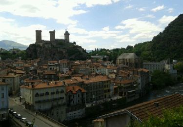
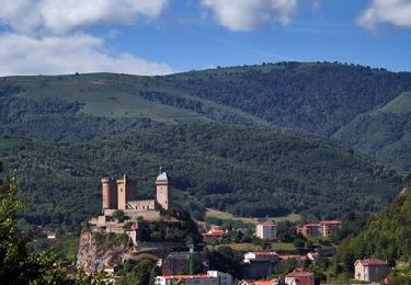
Trail Equestrian of 100 km to be discovered at Occitania, Ariège, Montgaillard. This trail is proposed by Lozère Cheval.

Description

sentier_cathare 001

Elevation profile

Points of interest

Point of interest Soula - Gite Le Pastourel - Photo
Lozère Cheval
Point of interest Soula - Infocus-du-sud  - Photo
Lozère Cheval
Point of interest Leychert - Gite du Pech Cathare - Photo
Lozère Cheval
Point of interest Montgaillard - Camping La roucateille - Photo
Lozère Cheval
Point of interest Roquefixade - Gite Roquefixade - Photo
Lozère Cheval
ROQUEFIXADE 
Point of interest Montferrier - Chambres d'Hôtes Labyrinth - Photo
Lozère Cheval
Point of interest Péreille - Gîte Tara - Photo
Lozère Cheval
PÉREILLE 
Point of interest Montferrier - Les Ninounettes - Photo
Lozère Cheval
MONTFERRIER 
Point of interest Montségur - GITES RURAUX DU SARRAT - Photo
Lozère Cheval
Point of interest Montségur - Càmping de Montsegur - Photo
Lozère Cheval
Point of interest Montségur - Simon Janos - Photo
Lozère Cheval
MONTSÉGUR 
Point of interest Montségur - Montségur- Hotel Couquet - Photo
Lozère Cheval
Point of interest Comus - Gite d'étape le Prébystère - Photo
Lozère Cheval
Point of interest Comus - Oustal Dé l'Annetta - Photo
Lozère Cheval
Point of interest Prades - Le Silence du Midi - Photo
Lozère Cheval
Point of interest Montferrier - Camping La Fount de Sicre - Photo
Lozère Cheval
Point of interest Montferrier - gite le Toupinat - Photo
Lozère Cheval
MONTFERRIER 
Point of interest Montferrier - Gite de France à Montferrier - Photo
Lozère Cheval
Point of interest Montségur - La Maison sous le chateau - Photo
Lozère Cheval
Point of interest Montségur - Gite Montségur le Caroulet - Photo
Lozère Cheval
Point of interest Montségur - Gîte Lespeyrots Montségur - Photo
Lozère Cheval
Point of interest Montségur - Gites Marcerou - Photo
Lozère Cheval
MONTSÉGUR 
Point of interest Montségur - Auberge de Montsegur - Photo
Lozère Cheval
Point of interest Comus - gîte Taranière - Photo
Lozère Cheval
Point of interest Comus - Refuge des Gardes - Photo
Lozère Cheval

Positioning

Country:
France
Region :
Occitania
Department/Province :
Ariège
Municipality :
Montgaillard
Location:
Unknown
Start:(UTM)
389107 ; 4754889 (31T) N.

Trails nearby

Trail Walking Prayols - Cuminge  - Photo
Walking
David Girabet

Walking

Easy
(1)
Prayols, Occitania, Ariège, France
3.5 km | 6.1 km-effort
1h 0min
Yes
Trail Walking Montoulieu - MONTOULIEU - GINABAT - Photo
Walking
RonanDAGORN

Walking

Medium
Montoulieu, Occitania, Ariège, France
7.1 km | 10.3 km-effort
1h 53min
Yes
Trail On foot Montoulieu - La cabane des gardes - Photo
On foot
c.chehere

On foot

Medium
Montoulieu, Occitania, Ariège, France
15.5 km | 25 km-effort
Unknown
Yes
Trail Walking Foix - 01 - FOIX à ROQUEFIXADE - Chemin des Bons-Hommes GR107 GR367 - Photo
Walking
jopost

Walking

Difficult
Foix, Occitania, Ariège, France
18.6 km | 30 km-effort
6h 36min
No
Trail Walking Saint-Paul-de-Jarrat - De Saint-Paul à Montgailhard - Photo
Walking
tracegps

Walking

Medium
Saint-Paul-de-Jarrat, Occitania, Ariège, France
9.9 km | 11.7 km-effort
2h 30min
Yes
Trail Walking Foix - pech de foix - Photo
Walking
christian425

Walking

Very easy
(1)
Foix, Occitania, Ariège, France
7.5 km | 13.6 km-effort
3h 43min
Yes
Trail Cycle Foix - A vélo en Basse Ariège - Foix - Photo
Cycle
tracegps

Cycle

Medium
Foix, Occitania, Ariège, France
97 km | 111 km-effort
4h 49min
Yes
Trail Cycle Foix - Port de Lers - Foix - Photo
Cycle
tracegps

Cycle

Difficult
Foix, Occitania, Ariège, France
115 km | 152 km-effort
6h 7min
Yes
Trail Cycle Foix - De Foix au lac de Montbel - Photo
Cycle
tracegps

Cycle

Difficult
Foix, Occitania, Ariège, France
104 km | 124 km-effort
5h 0min
Yes


Close
My subscriptions