Trail Mountain bike Pia - Pia -Barcarès -Sainte marie de la Mer -Canet dans les Pyrénées Orientales - Photo

Pia -Barcarès -Sainte marie de la Mer -Canet dans les Pyrénées Orientales

© OpenStreetMap contributors
Length
Length
42 km
Max alt
Max alt
31 m
Uphill gradient
Uphill gradient
194 m
Km-Effort
Km-Effort  
45 km
Min alt
Min alt
-2 m
Downhill gradient
Downhill gradient
194 m
Boucle
Boucle
Yes
Creation date :
2022-06-06 07:08:58.16
Updated on :
2022-06-11 14:48:36.139

(0 Reviews)

Mountain bike
Mountain bike
3h10
Difficulty : Easy

Scan this QR Code to open this trail in the SityTrail application

FREE GPS app for hiking

Logo SityTrail SityTrail

IGN / Geographical institutes

Download SityTrail from the App Store Download SityTrail from Google Play

Logo SityTrail SityTrail World

The world is yours!

Download SityTrail from the App Store Download SityTrail from Google Play Download SityTrail on Huawei AppGallery

About

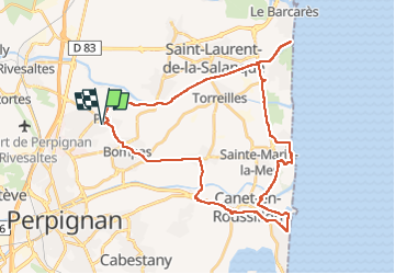
Trail Mountain bike of 42 km to be discovered at Occitania, Pyrénées-Orientales, Pia. This trail is proposed by MarieFrancoise.

Description

très jolie boucle sans aucune difficulté au départ du parking de Pia. chemins et pistes en bon état
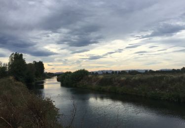
la 1ére partie se fait majoritairement en suivant l Agly jusqu à son embouchure au Barcarès
ensuite direction Sainte Marie puis continuer vers Canet Plage retour par Bompas
a signaler quelques très petits morceaux sur la route

Elevation profile

Photos

Positioning

Country:
France
Region :
Occitania
Department/Province :
Pyrénées-Orientales
Municipality :
Pia
Location:
Unknown
Start:(UTM)
493456 ; 4732259 (31T) N.

Trails nearby

Trail Walking Bompas - 66 BOMPAS - promenade en SALANQUE entre Bassas et Agullas - Photo
Walking
jeff66

Walking

Easy
(1)
Bompas, Occitania, Pyrénées-Orientales, France
11.1 km | 11.6 km-effort
2h 36min
Yes
Trail Walking Perpignan - Perpignan 01.10.2017  - Photo
Walking
jeff66

Walking

Easy
(1)
Perpignan, Occitania, Pyrénées-Orientales, France
6.7 km | 7.5 km-effort
1h 39min
No
Trail Walking Rivesaltes - 66 RIVESALTES promenade dans la cite, la vieille ville et rives d'Agly - Photo
Walking
jeff66

Walking

Easy
Rivesaltes, Occitania, Pyrénées-Orientales, France
5.2 km | 5.6 km-effort
1h 5min
Yes
Trail Walking Bompas - 66 BOMPAS - itinéraire partagé piétions cycliste en bord de Tet, berge Têt, Bas Vernet, retour par les canaux et centre ville de BOMPAS  - Photo
Walking
jeff66

Walking

Medium
Bompas, Occitania, Pyrénées-Orientales, France
13.4 km | 14.2 km-effort
2h 23min
Yes
Trail Walking Perpignan - 66 PERPIGNAN - clos Banet au Bas Vernet, retour par piste cyclable et BOMPAS, puis château Roussillon  - Photo
Walking
jeff66

Walking

Medium
Perpignan, Occitania, Pyrénées-Orientales, France
17 km | 18.4 km-effort
2h 49min
Yes
Trail Walking Perpignan - 66 PERPIGNAN polygone nord au Haut Vernet - Photo
Walking
jeff66

Walking

Medium
Perpignan, Occitania, Pyrénées-Orientales, France
10.4 km | 11 km-effort
1h 57min
Yes
Trail Walking Saint-Estève - 66 SAINT-ESTEVE, chemin du sacré cœur Perpignan - Photo
Walking
jeff66

Walking

Easy
Saint-Estève, Occitania, Pyrénées-Orientales, France
5.6 km | 5.9 km-effort
1h 0min
No
Trail Walking Rivesaltes - 66 RIVESALTES - promenade le long de l'Agly - Photo
Walking
jeff66

Walking

Very easy
Rivesaltes, Occitania, Pyrénées-Orientales, France
4.3 km | 4.6 km-effort
44min
Yes
Trail Walking Pia - 66 PIA - promenade en SALANQUE entre Basse, Llabanère et Agly - Photo
Walking
jeff66

Walking

Medium
Pia, Occitania, Pyrénées-Orientales, France
12.5 km | 13.1 km-effort
1h 59min
Yes


Close
My subscriptions