Trail Walking Goldbach-Altenbach - SityTrail - SityTrail - Firstacker-Chalet Grand Ballon 433m - Photo

SityTrail - SityTrail - Firstacker-Chalet Grand Ballon 433m

 E.BURCK
E.BURCK

User

© OpenStreetMap contributors
Length
Length
11.3 km
Max alt
Max alt
1338 m
Uphill gradient
Uphill gradient
437 m
Km-Effort
Km-Effort  
17.1 km
Min alt
Min alt
943 m
Downhill gradient
Downhill gradient
438 m
Boucle
Boucle
Yes
Creation date :
2022-07-26 13:10:29.325
Updated on :
2022-07-26 13:17:57.08

(0 Reviews)

Walking
Walking
3h47
Difficulty : Medium

Scan this QR Code to open this trail in the SityTrail application

FREE GPS app for hiking

Logo SityTrail SityTrail

IGN / Geographical institutes

Download SityTrail from the App Store Download SityTrail from Google Play

Logo SityTrail SityTrail World

The world is yours!

Download SityTrail from the App Store Download SityTrail from Google Play Download SityTrail on Huawei AppGallery

About

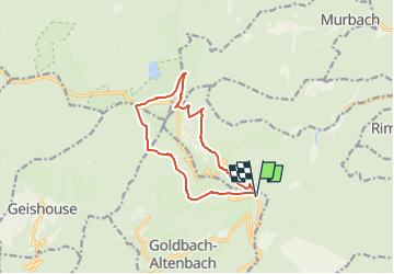
Trail Walking of 11.3 km to be discovered at Grand Est, Haut-Rhin, Goldbach-Altenbach. This trail is proposed by E.BURCK.

Description

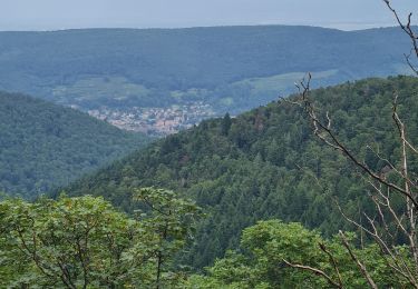
Une balade au frais, en altitude, vers le Grand Ballon.
Dénivelé de 430m avec une pente très régulière et une distance totale de 11 km. Nous prendrons le menu randonneur au Chalet Hôtel du Grand Ballon. L'établissement est propriété                 du Club Vosgien de Strasbourg.
ACCÈS :
- environ à 1.5 km après le col Amic en direction du Grand Ballon .
PARKING :
- Au col du Firstacker.
47.885830, 7.127657  ou  N 47°53'09", E 07°07'40"
RESTAURATION :      
Chalet Hôtel du Grand Ballon.
Tél: 03 89 48 77 99

Elevation profile

Positioning

Country:
France
Region :
Grand Est
Department/Province :
Haut-Rhin
Municipality :
Goldbach-Altenbach
Location:
Unknown
Start:(Dec)
Start:(UTM)
360027 ; 5305328 (32T) N.

Trails nearby

Trail Walking Soultz-Haut-Rhin - Hartmannswillerkopf - Circuit découverte - Photo
Walking
VacheKiri67

Walking

Easy
(1)
Soultz-Haut-Rhin, Grand Est, Haut-Rhin, France
3.6 km | 5.2 km-effort
1h 46min
Yes
Trail Walking Soultz-Haut-Rhin - Hartmannswillerkopf - Circuit anneau bleu - Photo
Walking
VacheKiri67

Walking

Medium
(1)
Soultz-Haut-Rhin, Grand Est, Haut-Rhin, France
3.7 km | 5.9 km-effort
1h 37min
Yes
Trail On foot Goldbach-Altenbach - Firstacker - Willer sur Thur - Photo
On foot
GUIDE+

On foot

Easy
Goldbach-Altenbach, Grand Est, Haut-Rhin, France
7.4 km | 9.6 km-effort
2h 11min
No
Trail Trail Wattwiller - The History Ultra - stage 1 - Photo
Trail
Olivier Houette

Trail

Very easy
(1)
Wattwiller, Grand Est, Haut-Rhin, France
28 km | 48 km-effort
Unknown
No
Trail Walking Murbach - Rando du 01/08/2024 - Photo
Walking
boubou68

Walking

Very difficult
Murbach, Grand Est, Haut-Rhin, France
18.9 km | 30 km-effort
5h 53min
Yes
Trail Walking Soultz-Haut-Rhin - Rando Marcheurs..04/04_2025 - Photo
Walking
boubou68

Walking

Very difficult
Soultz-Haut-Rhin, Grand Est, Haut-Rhin, France
21 km | 35 km-effort
4h 42min
Yes
Trail Walking Jungholtz - Rando Retrouvailles...01/03/2024.par Jean Marc - Photo
Walking
boubou68

Walking

Very difficult
Jungholtz, Grand Est, Haut-Rhin, France
11.3 km | 19.2 km-effort
1h 35min
Yes
Trail Walking Soultz-Haut-Rhin - Mon tour des Vosges (4 jours) - Photo
Walking
annefrance70

Walking

Very difficult
Soultz-Haut-Rhin, Grand Est, Haut-Rhin, France
71 km | 113 km-effort
25h 38min
Yes
Trail Walking Murbach - La
Walking
boubou68

Walking

Very difficult
Murbach, Grand Est, Haut-Rhin, France
14.7 km | 28 km-effort
4h 3min
Yes


Close
My subscriptions