Trail Walking Breitenbach - Breitenbach panoramique 8km - Photo

Breitenbach panoramique 8km

© OpenStreetMap contributors
Length
Length
7.8 km
Max alt
Max alt
443 m
Uphill gradient
Uphill gradient
231 m
Km-Effort
Km-Effort  
10.8 km
Min alt
Min alt
353 m
Downhill gradient
Downhill gradient
231 m
Boucle
Boucle
Yes
Creation date :
2022-10-23 17:37:52.031
Updated on :
2022-10-23 19:52:34.35

(0 Reviews)

Walking
Walking
2h27
Difficulty : Very easy

Scan this QR Code to open this trail in the SityTrail application

FREE GPS app for hiking

Logo SityTrail SityTrail

IGN / Geographical institutes

Download SityTrail from the App Store Download SityTrail from Google Play

Logo SityTrail SityTrail World

The world is yours!

Download SityTrail from the App Store Download SityTrail from Google Play Download SityTrail on Huawei AppGallery

About

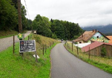
Trail Walking of 7.8 km to be discovered at Grand Est, Bas-Rhin, Breitenbach. This trail is proposed by Crapounette.

Description

départ Espace Socio culturel, sous l'église suivre Anneau jaune arrivée rue à droite voir walibis  puis retour et à droite puis gauche anneau rouge. Arrivée sur chemin descendre dans village 1ere à droite,traverser route sur la droite monter de suite à droite puis à gauche joli chemin au-dessus village et cimetière.  puis monter chemin à droite (réception parapente) puis à gauche et encore à gauche chemin descend puis à droite

Elevation profile

Positioning

Country:
France
Region :
Grand Est
Department/Province :
Bas-Rhin
Municipality :
Breitenbach
Location:
Unknown
Start:(UTM)
373371 ; 5358223 (32U) N.

Trails nearby

Trail Walking Steige - Steige  blanc  - Photo
Walking
jean charles daniel.

Walking

Medium
(1)
Steige, Grand Est, Bas-Rhin, France
7.8 km | 12.6 km-effort
2h 7min
Yes
Trail Walking Villé - 67 VILLÉ  CLIMONT VILLÉ  - Photo
Walking
LUTZMarc

Walking

Medium
(1)
Villé, Grand Est, Bas-Rhin, France
22 km | 33 km-effort
5h 5min
Yes
Trail Mountain bike Thanvillé - Circuit de la Gadouille - Photo
Mountain bike
tracegps

Mountain bike

Difficult
(3)
Thanvillé, Grand Est, Bas-Rhin, France
18.4 km | 27 km-effort
1h 40min
Yes
Trail Walking Le Hohwald - suuntoapp-Hiking-2024-04-27T09-12-29Z - Photo
Walking
GUIDE
holtzv

Walking

Medium
Le Hohwald, Grand Est, Bas-Rhin, France
20 km | 31 km-effort
6h 58min
Yes
Trail Walking Saint-Martin - 17.05.2020 - Saint Martin  - Photo
Walking
delm

Walking

Easy
(1)
Saint-Martin, Grand Est, Bas-Rhin, France
12.2 km | 17.7 km-effort
3h 56min
Yes
Trail Walking Le Hohwald - Tour du Hohwald - Photo
Walking
zazie

Walking

Medium
(1)
Le Hohwald, Grand Est, Bas-Rhin, France
8 km | 11.3 km-effort
2h 26min
Yes
Trail Mountain bike Maisonsgoutte - Honel - Photo
Mountain bike
sanseya

Mountain bike

Medium
(1)
Maisonsgoutte, Grand Est, Bas-Rhin, France
15 km | 22 km-effort
1h 26min
Yes
Trail Walking Le Hohwald - Hohwald - Rothlach - Neuntelstein - Photo
Walking
VacheKiri67

Walking

Medium
Le Hohwald, Grand Est, Bas-Rhin, France
15.8 km | 22 km-effort
4h 28min
Yes
Trail Horseback riding Belmont - Circuit VC Serva - Le Climont - Photo
Horseback riding
GUIDE+

Horseback riding

Medium
Belmont, Grand Est, Bas-Rhin, France
23 km | 33 km-effort
4h 20min
No


Close
My subscriptions