Trail Walking Saint-Marc-Jaumegarde - Barrage Zola depuis le barrage de Bimont - Photo
© OpenStreetMap contributors
Length
Length
7.5 km
Max alt
Max alt
374 m
Uphill gradient
Uphill gradient
224 m
Km-Effort
Km-Effort  
10.5 km
Min alt
Min alt
228 m
Downhill gradient
Downhill gradient
225 m
Boucle
Boucle
Yes
Creation date :
2023-05-06 17:20:48.65
Updated on :
2023-05-06 17:58:52.137

(0 Reviews)

Walking
Walking
2h23
Difficulty : Medium

Scan this QR Code to open this trail in the SityTrail application

FREE GPS app for hiking

Logo SityTrail SityTrail

IGN / Geographical institutes

Download SityTrail from the App Store Download SityTrail from Google Play

Logo SityTrail SityTrail World

The world is yours!

Download SityTrail from the App Store Download SityTrail from Google Play Download SityTrail on Huawei AppGallery

About

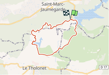
Trail Walking of 7.5 km to be discovered at Provence-Alpes-Côte d'Azur, Bouches-du-Rhône, Saint-Marc-Jaumegarde. This trail is proposed by ericberlin.

Description

La classique incontounable et facile en corniche avec panoramas magnifiques.
L’été, l' accès est réglementé, consulter la carte des conditions d’accès au massifs forestiers dans le 13 en fonction du risque d’incendies :
0811 20 13 13
http://bpatp.paca-ate.fr/
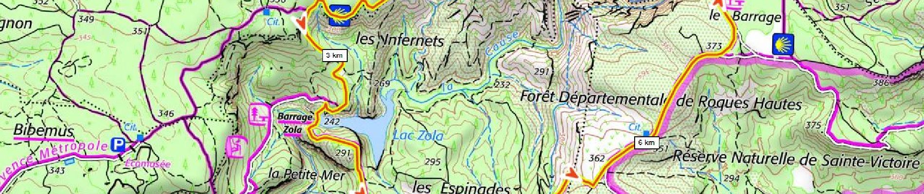
Grand parking et buvette au barrage de Bimont.
Bus: https://ampmetropole.fr/wp-content/uploads/2023/03/Le-Car-Ligne-140-Vauvenargues-Aix-en-Provence-Gare-RoutiŠre.pdf
https://fr.wikipedia.org/wiki/Barrage_de_Bimont
https://fr.wikipedia.org/wiki/Barrage_Zola
commentaires bienvenus !

Elevation profile

Photos

Positioning

Country:
France
Region :
Provence-Alpes-Côte d'Azur
Department/Province :
Bouches-du-Rhône
Municipality :
Saint-Marc-Jaumegarde
Location:
Unknown
Start:(UTM)
704610 ; 4824091 (31T) N.

Trails nearby

Trail Walking Saint-Antonin-sur-Bayon - Ste Victoire - Le Garagaï - Photo
Walking
ETMU5496

Walking

Difficult
(1)
Saint-Antonin-sur-Bayon, Provence-Alpes-Côte d'Azur, Bouches-du-Rhône, France
15.8 km | 28 km-effort
4h 36min
Yes
Trail Walking Aix-en-Provence - Circuit des lacs Zola et Bimont - Aix-en-Provence - Photo
Walking
tracegps

Walking

Medium
(4)
Aix-en-Provence, Provence-Alpes-Côte d'Azur, Bouches-du-Rhône, France
10 km | 13.6 km-effort
2h 30min
Yes
Trail Walking Saint-Marc-Jaumegarde - Barrages Zola-Bimont - Photo
Walking
Berpav

Walking

Medium
(2)
Saint-Marc-Jaumegarde, Provence-Alpes-Côte d'Azur, Bouches-du-Rhône, France
8 km | 11 km-effort
2h 30min
Yes
Trail Walking Vauvenargues - Le Signal, Montagne Sainte-Victoire - Photo
Walking
tracegps

Walking

Medium
(2)
Vauvenargues, Provence-Alpes-Côte d'Azur, Bouches-du-Rhône, France
15 km | 25 km-effort
6h 19min
Yes
Trail Walking Saint-Marc-Jaumegarde - La Croix de Provence depuis le barrage de Bimont - Photo
Walking
tracegps

Walking

Difficult
(1)
Saint-Marc-Jaumegarde, Provence-Alpes-Côte d'Azur, Bouches-du-Rhône, France
13.9 km | 24 km-effort
4h 45min
Yes
Trail Walking Saint-Antonin-sur-Bayon - 2023-02-10 Sainte Victoire Bau des Vespres - Photo
Walking
GUIDE
Kargil

Walking

Difficult
Saint-Antonin-sur-Bayon, Provence-Alpes-Côte d'Azur, Bouches-du-Rhône, France
10 km | 18.8 km-effort
3h 30min
Yes
Trail On foot Vauvenargues - Sentier des Venturiers - Photo
On foot
PRO

On foot

Easy
Vauvenargues, Provence-Alpes-Côte d'Azur, Bouches-du-Rhône, France
5 km | 10.5 km-effort
2h 23min
No
Trail On foot Beaurecueil - Sentier Imoucha - Photo
On foot
PRO

On foot

Easy
Beaurecueil, Provence-Alpes-Côte d'Azur, Bouches-du-Rhône, France
4.4 km | 10.1 km-effort
2h 17min
No
Trail Walking Saint-Antonin-sur-Bayon - pas du clapier et tracé vert - Photo
Walking
GUIDE
amiral13

Walking

Difficult
Saint-Antonin-sur-Bayon, Provence-Alpes-Côte d'Azur, Bouches-du-Rhône, France
10.5 km | 21 km-effort
5h 24min
Yes


Close
My subscriptions