Trail Walking Gorbio - Cime de Baudon - Photo
 xelot
xelot

User

© OpenStreetMap contributors
Length
Length
14.1 km
Max alt
Max alt
1241 m
Uphill gradient
Uphill gradient
1017 m
Km-Effort
Km-Effort  
28 km
Min alt
Min alt
358 m
Downhill gradient
Downhill gradient
1028 m
Boucle
Boucle
Yes
Creation date :
2015-01-29 00:00:00.0
Updated on :
2015-01-29 00:00:00.0

(0 Reviews)

Walking
Walking
5h53
Difficulty : Difficult

Scan this QR Code to open this trail in the SityTrail application

FREE GPS app for hiking

Logo SityTrail SityTrail

IGN / Geographical institutes

Download SityTrail from the App Store Download SityTrail from Google Play

Logo SityTrail SityTrail World

The world is yours!

Download SityTrail from the App Store Download SityTrail from Google Play Download SityTrail on Huawei AppGallery

About

Trail Walking of 14.1 km to be discovered at Provence-Alpes-Côte d'Azur, Maritime Alps, Gorbio. This trail is proposed by xelot.

Description

Départ de Gorbio. Randonnée pas très longue mais avec un bon dénivelé.

Elevation profile

Positioning

Country:
France
Region :
Provence-Alpes-Côte d'Azur
Department/Province :
Maritime Alps
Municipality :
Gorbio
Location:
Unknown
Start:(UTM)
374652 ; 4849369 (32T) N.

Trails nearby

Trail Walking Castellar - Mont Carpano en boucle - Photo
Walking
boboazur

Walking

Medium
(1)
Castellar, Provence-Alpes-Côte d'Azur, Maritime Alps, France
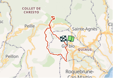
8.1 km | 14.4 km-effort
3h 18min
Yes
Trail Walking Peillon - Via Alpina - R161: Peillon > Monaco - Place du Palais - Photo
Walking
tracegps

Walking

Medium
(2)
Peillon, Provence-Alpes-Côte d'Azur, Maritime Alps, France
10.3 km | 16.7 km-effort
2h 49min
No
Trail On foot Peille - Cime de Baudon - Photo
On foot
PRO

On foot

Easy
Peille, Provence-Alpes-Côte d'Azur, Maritime Alps, France
7 km | 14.7 km-effort
3h 20min
Yes
Trail Walking Roquebrune-Cap-Martin - cape martin - Photo
Walking
danpar

Walking

Medium
(2)
Roquebrune-Cap-Martin, Provence-Alpes-Côte d'Azur, Maritime Alps, France
4.4 km | 5.9 km-effort
1h 57min
Yes
Trail Other activity La Turbie - fort de la Revere  - Photo
Other activity
juleyann

Other activity

Very easy
(1)
La Turbie, Provence-Alpes-Côte d'Azur, Maritime Alps, France
8.4 km | 12 km-effort
1h 37min
Yes
Trail Walking Peille - Cime de Baudon - Photo
Walking
maxcagaze

Walking

Medium
(1)
Peille, Provence-Alpes-Côte d'Azur, Maritime Alps, France
7.8 km | 15.7 km-effort
4h 15min
Yes
Trail Walking Castellar - mont carpano au départ de Castellar - Photo
Walking
56jj

Walking

Medium
Castellar, Provence-Alpes-Côte d'Azur, Maritime Alps, France
7.7 km | 13.9 km-effort
5h 14min
Yes
Trail Walking Castellar - Castellane - roc d'Ormea - Photo
Walking
patsure

Walking

Medium
Castellar, Provence-Alpes-Côte d'Azur, Maritime Alps, France
9.7 km | 20 km-effort
3h 26min
No
Trail Walking Peille - La Lourquiere au départ de la gare de Grave de Peille - Photo
Walking
Renefrt

Walking

Medium
Peille, Provence-Alpes-Côte d'Azur, Maritime Alps, France
8.5 km | 13.5 km-effort
5h 48min
No


Close
My subscriptions