Trail Walking Goldbach-Altenbach - Goldbach - Col du Haag - Firstacker - Col Amic - Goldbach - Photo

Goldbach - Col du Haag - Firstacker - Col Amic - Goldbach

© OpenStreetMap contributors
Length
Length
15.1 km
Max alt
Max alt
1351 m
Uphill gradient
Uphill gradient
752 m
Km-Effort
Km-Effort  
25 km
Min alt
Min alt
624 m
Downhill gradient
Downhill gradient
759 m
Boucle
Boucle
Yes
Creation date :
2023-10-04 19:31:45.872
Updated on :
2023-10-04 19:34:07.821

(0 Reviews)

Walking
Walking
5h43
Difficulty : Very difficult

Scan this QR Code to open this trail in the SityTrail application

FREE GPS app for hiking

Logo SityTrail SityTrail

IGN / Geographical institutes

Download SityTrail from the App Store Download SityTrail from Google Play

Logo SityTrail SityTrail World

The world is yours!

Download SityTrail from the App Store Download SityTrail from Google Play Download SityTrail on Huawei AppGallery

About

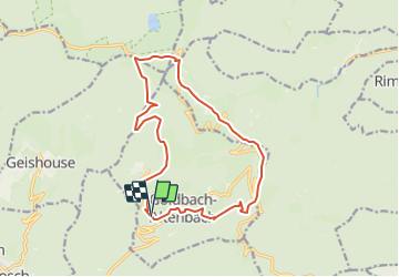
Trail Walking of 15.1 km to be discovered at Grand Est, Haut-Rhin, Goldbach-Altenbach. This trail is proposed by FIGLIUZZI.

Description

Belle randonnée, chemins faciles. Option possible, la montée au Grand Ballon. Tables disponibles pour le repas de midi au chalet du Grd Ballon.

Elevation profile

Positioning

Country:
France
Region :
Grand Est
Department/Province :
Haut-Rhin
Municipality :
Goldbach-Altenbach
Location:
Unknown
Start:(UTM)
357536 ; 5303840 (32T) N.

Trails nearby

Trail Walking Soultz-Haut-Rhin - Hartmannswillerkopf - Circuit découverte - Photo
Walking
VacheKiri67

Walking

Easy
(1)
Soultz-Haut-Rhin, Grand Est, Haut-Rhin, France
3.6 km | 5.2 km-effort
1h 46min
Yes
Trail Walking Soultz-Haut-Rhin - Hartmannswillerkopf - Circuit anneau bleu - Photo
Walking
VacheKiri67

Walking

Medium
(1)
Soultz-Haut-Rhin, Grand Est, Haut-Rhin, France
3.7 km | 5.9 km-effort
1h 37min
Yes
Trail Other activity Steinbach - lac du ballon - Photo
Other activity
rodabruna

Other activity

Very easy
(1)
Steinbach, Grand Est, Haut-Rhin, France
33 km | 64 km-effort
5h 1min
No
Trail On foot Goldbach-Altenbach - Firstacker - Willer sur Thur - Photo
On foot
GUIDE+

On foot

Easy
Goldbach-Altenbach, Grand Est, Haut-Rhin, France
7.4 km | 9.6 km-effort
2h 11min
No
Trail Trail Wattwiller - The History Ultra - stage 1 - Photo
Trail
Olivier Houette

Trail

Very easy
(1)
Wattwiller, Grand Est, Haut-Rhin, France
28 km | 48 km-effort
Unknown
No
Trail On foot Bitschwiller-lès-Thann - Bitschwiller les Thann - Rehbrunnel - Abri du Becherkopf - Roche Albert - Photo
On foot
patrickbeyrath

On foot

Medium
(1)
Bitschwiller-lès-Thann, Grand Est, Haut-Rhin, France
10.3 km | 16.4 km-effort
Unknown
Yes
Trail Walking Soultz-Haut-Rhin - Mon tour des Vosges (4 jours) - Photo
Walking
annefrance70

Walking

Very difficult
Soultz-Haut-Rhin, Grand Est, Haut-Rhin, France
71 km | 113 km-effort
25h 38min
Yes
Trail Walking Saint-Amarin - dimanche - Photo
Walking
Ninie38MD

Walking

Very difficult
(1)
Saint-Amarin, Grand Est, Haut-Rhin, France
19.4 km | 35 km-effort
7h 51min
Yes
Trail Walking Moosch - Moosch Haag - Photo
Walking
Estelle Handschin

Walking

Difficult
(1)
Moosch, Grand Est, Haut-Rhin, France
21 km | 0 m-effort
5h 27min
Yes


Close
My subscriptions