Trail Walking Calmels-et-le-Viala - Viala Cagné Tournet Sounpette Ruminier le Moulin le Viala - Photo

Viala Cagné Tournet Sounpette Ruminier le Moulin le Viala

© OpenStreetMap contributors
Length
Length
8.9 km
Max alt
Max alt
490 m
Uphill gradient
Uphill gradient
314 m
Km-Effort
Km-Effort  
13 km
Min alt
Min alt
277 m
Downhill gradient
Downhill gradient
310 m
Boucle
Boucle
Yes
Creation date :
2023-11-11 15:13:08.259
Updated on :
2023-11-12 07:51:30.437

(0 Reviews)

Walking
Walking
2h57
Difficulty : Difficult

Scan this QR Code to open this trail in the SityTrail application

FREE GPS app for hiking

Logo SityTrail SityTrail

IGN / Geographical institutes

Download SityTrail from the App Store Download SityTrail from Google Play

Logo SityTrail SityTrail World

The world is yours!

Download SityTrail from the App Store Download SityTrail from Google Play Download SityTrail on Huawei AppGallery

About

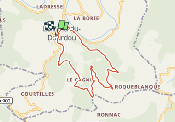
Trail Walking of 8.9 km to be discovered at Occitania, Aveyron, Calmels-et-le-Viala. This trail is proposed by Bernard Constans.

Description

Depuis le Viala direction le Cagné pour 2 km de petite route, Descente sur le ruisseau du Maxillou puis direction à gauche le Tournet et les Estévénens. Montée sur la crête de la sounpette et direction le Mas del Roc via le versant du ruminier. Remontée sur le Viala par le chemin au dessus du Moulin.

Elevation profile

Positioning

Country:
France
Region :
Occitania
Department/Province :
Aveyron
Municipality :
Calmels-et-le-Viala
Location:
Unknown
Start:(UTM)
480045 ; 4865816 (31T) N.

Trails nearby

Trail Walking Saint-Izaire - st izaire - Photo
Walking
nanie

Walking

Very easy
(1)
Saint-Izaire, Occitania, Aveyron, France
13.1 km | 19.6 km-effort
5h 55min
Yes
Trail Walking Rebourguil - Ennous in live - Photo
Walking
CASSISFRAMBOISE

Walking

Medium
(1)
Rebourguil, Occitania, Aveyron, France
21 km | 30 km-effort
4h 47min
Yes
Trail Walking Saint-Izaire - Saint Izaire - Photo
Walking
Frayssinet

Walking

Very difficult
Saint-Izaire, Occitania, Aveyron, France
19.5 km | 29 km-effort
6h 37min
Yes
Trail Walking Saint-Izaire - st izaire douce - Photo
Walking
CASSISFRAMBOISE

Walking

Easy
Saint-Izaire, Occitania, Aveyron, France
8.5 km | 12 km-effort
1h 55min
Yes
Trail On foot Saint-Juéry - Saint Juéry Esplas - Photo
On foot
sergedurand

On foot

Easy
Saint-Juéry, Occitania, Aveyron, France
11.7 km | 15.7 km-effort
3h 33min
Yes
Trail Walking Saint-Izaire - Saint izaire  2023 - Photo
Walking
Frayssinet

Walking

Very difficult
Saint-Izaire, Occitania, Aveyron, France
22 km | 32 km-effort
7h 11min
Yes
Trail Other activity Saint-Izaire - Circuit pédestre du St-Affricain
Other activity
tbrunet

Other activity

Very easy
Saint-Izaire, Occitania, Aveyron, France
10 km | 14.5 km-effort
Unknown
Yes
Trail Mountain bike Saint-Izaire - Saint Izaire 2012 - Photo
Mountain bike
J-Mi

Mountain bike

Difficult
Saint-Izaire, Occitania, Aveyron, France
31 km | 44 km-effort
2h 45min
Yes
Trail Walking Saint-Affrique - BOURNAC  - Photo
Walking
CASSISFRAMBOISE

Walking

Very difficult
Saint-Affrique, Occitania, Aveyron, France
17 km | 24 km-effort
5h 32min
Yes


Close
My subscriptions