Trail Walking Placey - Placeý - Photo
© OpenStreetMap contributors
Length
Length
13.5 km
Max alt
Max alt
287 m
Uphill gradient
Uphill gradient
294 m
Km-Effort
Km-Effort  
17.4 km
Min alt
Min alt
207 m
Downhill gradient
Downhill gradient
297 m
Boucle
Boucle
Yes
Creation date :
2023-11-26 08:37:55.44
Updated on :
2023-11-26 20:02:03.816

(0 Reviews)

Walking
Walking
3h57
Difficulty : Easy

Scan this QR Code to open this trail in the SityTrail application

FREE GPS app for hiking

Logo SityTrail SityTrail

IGN / Geographical institutes

Download SityTrail from the App Store Download SityTrail from Google Play

Logo SityTrail SityTrail World

The world is yours!

Download SityTrail from the App Store Download SityTrail from Google Play Download SityTrail on Huawei AppGallery

About

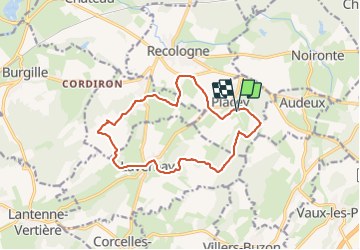
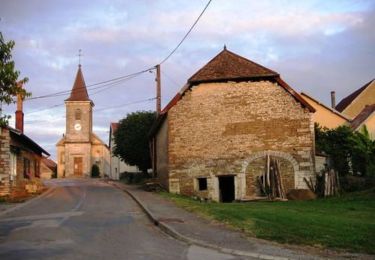
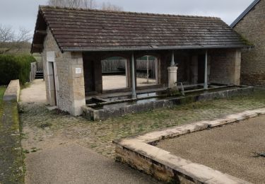
Trail Walking of 13.5 km to be discovered at Bourgogne-Franche-Comté, Doubs, Placey. This trail is proposed by eltonnermou.

Description

randonnée proche de celle intitulée "Lavernay".
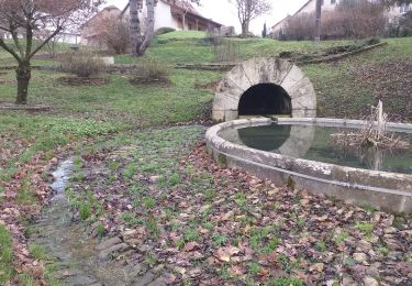
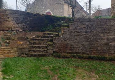
ce parcours pédestre agréable, vous emmènera à travers prairie et villages de la plaine du Doubs. Quelques curiosités (point de vue, bâtisse, fontaines ...) à regarder, observer en parcours, et sur la fin vous pourrez faire le tour de la "motte féodale" avec une explication de la chose.
pour faciliter votre progression (évite une traversée de ronce et puis de barbelé), à environ 5,7km du départ (après Franey et après la fontaine de Vauchon) en arrivant sur ce chemin transversal, partez à droite (et non à gauche), à environ 500m plus loin au croisement partir à gauche, puis laisser un chemin à main droite en poursuivant tout droit, à la pâte d'oie suivante prendre à gauche et rejoindre la trace.
laissez vous surprendre par la faune, et suivant les saisons par la flore.

Elevation profile

Photos

Positioning

Country:
France
Region :
Bourgogne-Franche-Comté
Department/Province :
Doubs
Municipality :
Placey
Location:
Unknown
Start:(UTM)
715545 ; 5237902 (31T) N.

Trails nearby

Trail Mountain bike Audeux - audeux classik 30 - Photo
Mountain bike
nono25170

Mountain bike

Very easy
(2)
Audeux, Bourgogne-Franche-Comté, Doubs, France
29 km | 36 km-effort
1h 15min
Yes
Trail Walking Chaucenne - chaucenne long - Photo
Walking
eltonnermou

Walking

Medium
Chaucenne, Bourgogne-Franche-Comté, Doubs, France
22 km | 25 km-effort
3h 44min
Yes
Trail Walking Chaucenne - chaucen..ne perd rien - Photo
Walking
eltonnermou

Walking

Easy
(1)
Chaucenne, Bourgogne-Franche-Comté, Doubs, France
13.9 km | 16.8 km-effort
3h 49min
Yes
Trail Walking Corcondray - corcondray  - Photo
Walking
eltonnermou

Walking

Medium
Corcondray, Bourgogne-Franche-Comté, Doubs, France
28 km | 34 km-effort
4h 23min
Yes
Trail Walking Lavernay - Lavernay  - Photo
Walking
eltonnermou

Walking

Very easy
(1)
Lavernay, Bourgogne-Franche-Comté, Doubs, France
12.4 km | 15.5 km-effort
1h 52min
Yes
Trail Walking Chevigney-sur-l'Ognon - CHEVIGNEY SUR L'OGNON - Photo
Walking
legios84

Walking

Easy
Chevigney-sur-l'Ognon, Bourgogne-Franche-Comté, Doubs, France
8.9 km | 10.1 km-effort
1h 55min
No
Trail Walking Recologne - Recologne Noironte 4 fév 2020 CAF  - Photo
Walking
TRIMAILLE

Walking

Medium
Recologne, Bourgogne-Franche-Comté, Doubs, France
20 km | 24 km-effort
6h 13min
Yes
Trail Mountain bike Chemaudin et Vaux - Les Ruisseaux de l'Ouest - Photo
Mountain bike
tracegps

Mountain bike

Difficult
Chemaudin et Vaux, Bourgogne-Franche-Comté, Doubs, France
40 km | 51 km-effort
4h 0min
Yes
Trail Walking Lavernay - lavernay - Photo
Walking
lime

Walking

Easy
Lavernay, Bourgogne-Franche-Comté, Doubs, France
12 km | 15.3 km-effort
2h 37min
Yes


Close
My subscriptions