Trail Walking Cuers - pilon St Clément-06-03-2024 - Photo

pilon St Clément-06-03-2024

© OpenStreetMap contributors
Length
Length
18.5 km
Max alt
Max alt
698 m
Uphill gradient
Uphill gradient
825 m
Km-Effort
Km-Effort  
30 km
Min alt
Min alt
185 m
Downhill gradient
Downhill gradient
822 m
Boucle
Boucle
Yes
Creation date :
2024-03-06 07:32:07.493
Updated on :
2024-03-07 17:07:52.572

(0 Reviews)

Walking
Walking
7h04
Difficulty : Medium

Scan this QR Code to open this trail in the SityTrail application

FREE GPS app for hiking

Logo SityTrail SityTrail

IGN / Geographical institutes

Download SityTrail from the App Store Download SityTrail from Google Play

Logo SityTrail SityTrail World

The world is yours!

Download SityTrail from the App Store Download SityTrail from Google Play Download SityTrail on Huawei AppGallery

About

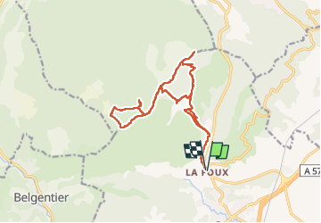
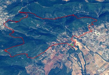
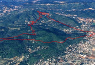
Trail Walking of 18.5 km to be discovered at Provence-Alpes-Côte d'Azur, Var, Cuers. This trail is proposed by Christiancordin.

Description

Départ PK la Foux, vallon de la Rouvéreide, pas de Cuers, barre de Cuers, pas de Riquier, les Eigras, pas de Brusquet, pilon de St Clément, le Brusquet, vallon du jas de Mourrier.

Elevation profile

Photos

Positioning

Country:
France
Region :
Provence-Alpes-Côte d'Azur
Department/Province :
Var
Municipality :
Cuers
Location:
Unknown
Start:(UTM)
261717 ; 4793068 (32T) N.

Trails nearby

Trail Mountain bike Rocbaron - La Chapelle Sainte-Philomène - Rocbaron - Photo
Mountain bike
tracegps

Mountain bike

Difficult
(1)
Rocbaron, Provence-Alpes-Côte d'Azur, Var, France
25 km | 34 km-effort
4h 0min
Yes
Trail Walking Rocbaron - le pilon Saint Clément et les barres de Cuers - Photo
Walking
GUIDE
amiral13

Walking

Medium
Rocbaron, Provence-Alpes-Côte d'Azur, Var, France
15.9 km | 24 km-effort
6h 0min
Yes
Trail Walking Belgentier - Wikiloc - Belgentier - Photo
Walking
GUIDE
affinetataille

Walking

Medium
(1)
Belgentier, Provence-Alpes-Côte d'Azur, Var, France
10.7 km | 18.3 km-effort
5h 0min
Yes
Trail Walking Cuers - la foux cuers opidum - Photo
Walking
marchev

Walking

Difficult
(2)
Cuers, Provence-Alpes-Côte d'Azur, Var, France
15.1 km | 25 km-effort
6h 8min
Yes
Trail Walking Rocbaron - pilon saint Clément et barres de cuers - Photo
Walking
FSantoni

Walking

Difficult
Rocbaron, Provence-Alpes-Côte d'Azur, Var, France
12.5 km | 18.6 km-effort
6h 16min
Yes
Trail Walking Cuers - valcros ste christine - Photo
Walking
cdanielrando

Walking

Very difficult
Cuers, Provence-Alpes-Côte d'Azur, Var, France
15.2 km | 24 km-effort
5h 21min
Yes
Trail Walking Puget-Ville - SityTrail - Terre blanche et tour du Faucon départ de Puget ville  - Photo
Walking
GUIDE
affinetataille

Walking

Medium
Puget-Ville, Provence-Alpes-Côte d'Azur, Var, France
15.1 km | 23 km-effort
6h 0min
Yes
Trail Walking Cuers - 2021-04-10_15h53m44_apie de sambalettes a partir de st christine - Photo
Walking
GUIDE
affinetataille

Walking

Medium
Cuers, Provence-Alpes-Côte d'Azur, Var, France
17.5 km | 26 km-effort
6h 0min
Yes
Trail Walking Cuers - Le Castellas Cuers - Photo
Walking
Christiancordin

Walking

Medium
(1)
Cuers, Provence-Alpes-Côte d'Azur, Var, France
13.8 km | 20 km-effort
3h 49min
Yes


Close
My subscriptions