Trail Mountain bike Saint-Agrève - annonay - st agreve - Photo
© OpenStreetMap contributors
Length
Length
54 km
Max alt
Max alt
1338 m
Uphill gradient
Uphill gradient
1020 m
Km-Effort
Km-Effort  
70 km
Min alt
Min alt
415 m
Downhill gradient
Downhill gradient
1670 m
Boucle
Boucle
No
Creation date :
2015-05-17 00:00:00.0
Updated on :
2015-05-17 00:00:00.0

(0 Reviews)

Mountain bike
Mountain bike
4h23
Difficulty : Medium

Scan this QR Code to open this trail in the SityTrail application

FREE GPS app for hiking

Logo SityTrail SityTrail

IGN / Geographical institutes

Download SityTrail from the App Store Download SityTrail from Google Play

Logo SityTrail SityTrail World

The world is yours!

Download SityTrail from the App Store Download SityTrail from Google Play Download SityTrail on Huawei AppGallery

About

Trail Mountain bike of 54 km to be discovered at Auvergne-Rhône-Alpes, Ardèche, Saint-Agrève. This trail is proposed by lionel4806.

Description

boulieu les Annonay a st agreve par le GR

Elevation profile

Positioning

Country:
France
Region :
Auvergne-Rhône-Alpes
Department/Province :
Ardèche
Municipality :
Saint-Agrève
Location:
Unknown
Start:(UTM)
610753 ; 4988086 (31T) N.

Trails nearby

Trail Walking Saint-Jeure-d'Andaure - En pays d'Andaure - Photo
Walking
tracegps

Walking

Medium
(1)
Saint-Jeure-d'Andaure, Auvergne-Rhône-Alpes, Ardèche, France
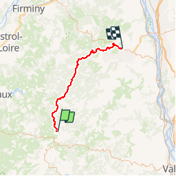
6.8 km | 10.1 km-effort
2h 30min
Yes
Trail Walking Saint-Agrève - La chaux par les Sagnoles - Photo
Walking
mallovon

Walking

Medium
(1)
Saint-Agrève, Auvergne-Rhône-Alpes, Ardèche, France
6.4 km | 8.9 km-effort
2h 17min
Yes
Trail Walking Saint-Agrève - Le serre par le col de brun - Photo
Walking
mallovon

Walking

Easy
Saint-Agrève, Auvergne-Rhône-Alpes, Ardèche, France
4.1 km | 5.1 km-effort
1h 20min
Yes
Trail Walking Le Chambon-sur-Lignon - Le Cholet (43) - Photo
Walking
Thomasdanielle

Walking

Difficult
Le Chambon-sur-Lignon, Auvergne-Rhône-Alpes, Haute-Loire, France
14.8 km | 19 km-effort
3h 43min
Yes
Trail Mountain bike Saint-Agrève - Château de Flossac - Saint Agrève - Photo
Mountain bike
tracegps

Mountain bike

Medium
Saint-Agrève, Auvergne-Rhône-Alpes, Ardèche, France
14.5 km | 19.1 km-effort
2h 0min
Yes
Trail Walking Saint-Agrève - Château de Flossac - Saint Agrève - Photo
Walking
tracegps

Walking

Medium
Saint-Agrève, Auvergne-Rhône-Alpes, Ardèche, France
14.5 km | 19.1 km-effort
4h 0min
Yes
Trail Walking Devesset - Tour du lac Devesset - Photo
Walking
DoChou

Walking

Very easy
Devesset, Auvergne-Rhône-Alpes, Ardèche, France
4.9 km | 5.8 km-effort
1h 18min
Yes
Trail Walking Devesset - le grail - Photo
Walking
berlan2

Walking

Very easy
Devesset, Auvergne-Rhône-Alpes, Ardèche, France
12 km | 0 m-effort
4h 2min
Yes
Trail Walking Saint-Agrève - La Galoche 2013 - Saint Agrève - Photo
Walking
tracegps

Walking

Medium
Saint-Agrève, Auvergne-Rhône-Alpes, Ardèche, France
19.5 km | 29 km-effort
5h 0min
Yes


Close
My subscriptions