Trail Other activity Sainte-Rose - La Réunion - Le volcan - Nez Coupé par le parking Fo-Foc - Photo

La Réunion - Le volcan - Nez Coupé par le parking Fo-Foc

 olive2b
olive2b

User

© OpenStreetMap contributors
Length
Length
11.4 km
Max alt
Max alt
2352 m
Uphill gradient
Uphill gradient
69 m
Km-Effort
Km-Effort  
13.7 km
Min alt
Min alt
1908 m
Downhill gradient
Downhill gradient
497 m
Boucle
Boucle
No
Creation date :
2016-03-09 00:00:00.0
Updated on :
2016-03-09 00:00:00.0

(1 Reviews)

Other activity
Other activity
3h17
Difficulty : Medium

Scan this QR Code to open this trail in the SityTrail application

FREE GPS app for hiking

Logo SityTrail SityTrail

IGN / Geographical institutes

Download SityTrail from the App Store Download SityTrail from Google Play

Logo SityTrail SityTrail World

The world is yours!

Download SityTrail from the App Store Download SityTrail from Google Play Download SityTrail on Huawei AppGallery

About

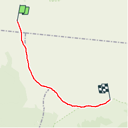
Trail Other activity of 11.4 km to be discovered at Réunion, Unknown, Sainte-Rose. This trail is proposed by olive2b.

Description

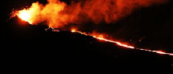
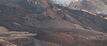
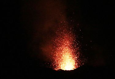
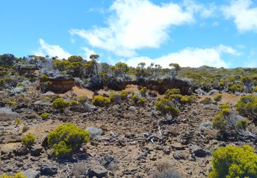
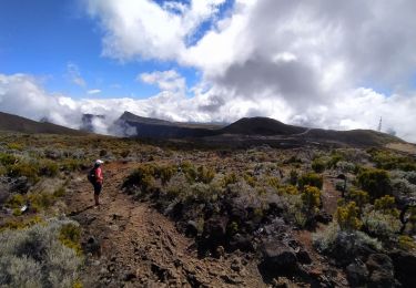
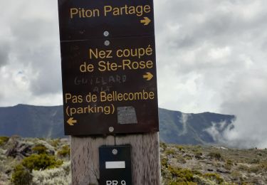
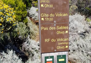
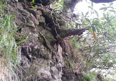
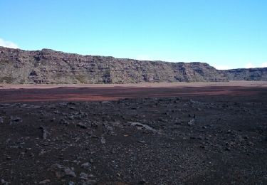
Le départ se fait par le parking de Foc-Foc à la plaine des sables. La première partie se fait tranquillement jusqu'au Piton de Bert ou Piton de Bois Vert. Après c'est de la descente sur un chemin très gras, avec des flaques. A l’arrivée du point de vue du Nez Coupé, on a une vue sur le volcan avec le Château Fort en premier plan. Cette sortie a été effectuée le 24 mai à minuit pour voir la coulée de lave de l'éruption du 17 mai 2015.

Elevation profile

Photos

Points of interest

Point of interest Saint-Philippe - Eruption du 17 mai 2015 - Photo
olive2b
SAINT-PHILIPPE 
Point of interest Saint-Philippe - Eruption du 17 mai 2015 - Photo
olive2b
SAINT-PHILIPPE 
Point of interest Saint-Philippe - Eruption du 17 mai 2015 - Photo
olive2b
SAINT-PHILIPPE 
Point of interest Saint-Philippe - Eruption du 17 mai 2015 - Photo
olive2b
SAINT-PHILIPPE 

Positioning

Country:
France
Region :
Réunion
Department/Province :
Unknown
Municipality :
Sainte-Rose
Location:
Unknown
Start:(UTM)
362292 ; 7651558 (40K) S.

Comments

Please log in to post a review or rate the element


Incroyable !


Trails nearby

Trail Walking Sainte-Rose - RandoPitons.re #1700 - Du Pas de Bellecombe au Piton Rouge par le sentier de bord - Photo
Walking
GUIDE
Rui Barbosa

Walking

Medium
(1)
Sainte-Rose, Réunion, Unknown, France
7.6 km | 9.2 km-effort
2h 4min
Yes
Trail Walking Sainte-Rose - La Réunion - Éruption de mai 2015 - Photo
Walking
olive2b

Walking

Easy
(1)
Sainte-Rose, Réunion, Unknown, France
8.9 km | 10.5 km-effort
2h 15min
No
Trail Walking Saint-Joseph - Morne Langevin  - Photo
Walking
sylviedaniel

Walking

Easy
Saint-Joseph, Réunion, Unknown, France
10.7 km | 14.4 km-effort
2h 43min
Yes
Trail Walking Le Tampon - Piton de l'eau par le Rempart de la Rivière de l'Est - Photo
Walking
sylviedaniel

Walking

Medium
Le Tampon, Réunion, Unknown, France
18.4 km | 27 km-effort
5h 0min
Yes
Trail Walking Sainte-Rose - bellecombe dolomieu - Photo
Walking
RoMo

Walking

Difficult
Sainte-Rose, Réunion, Unknown, France
15.2 km | 24 km-effort
6h 6min
No
Trail Walking Saint-Joseph - Boucle autour de la plaine des sables - Photo
Walking
lgmalherbe

Walking

Difficult
Saint-Joseph, Réunion, Unknown, France
16.2 km | 21 km-effort
4h 49min
Yes
Trail Walking Saint-Joseph - La Réunion - Retour - Ravine Citron Galet par le nez de Boeufs  - Photo
Walking
olive2b

Walking

Medium
Saint-Joseph, Réunion, Unknown, France
8.4 km | 24 km-effort
2h 9min
Yes
Trail Walking Saint-Joseph - La Réunion - Boucle de la Plaine des sables par l'Oratoire Sainte-Thérèse - Photo
Walking
olive2b

Walking

Medium
Saint-Joseph, Réunion, Unknown, France
15.8 km | 21 km-effort
5h 40min
Yes
Trail Walking Sainte-Rose - chisny - Photo
Walking
chouchou-slc

Walking

Very easy
Sainte-Rose, Réunion, Unknown, France
3.8 km | 5 km-effort
1h 5min
No


Close
My subscriptions