Trail Walking Villers-la-Ville - Sart-dames-avelines - Photo
 pascalou73
pascalou73

User GUIDE

© OpenStreetMap contributors
Length
Length
8.1 km
Max alt
Max alt
150 m
Uphill gradient
Uphill gradient
101 m
Km-Effort
Km-Effort  
9.4 km
Min alt
Min alt
109 m
Downhill gradient
Downhill gradient
93 m
Boucle
Boucle
Yes
Creation date :
2017-07-15 00:00:00.0
Updated on :
2017-07-15 00:00:00.0

(0 Reviews)

Walking
Walking
2h03
Difficulty : Medium

Scan this QR Code to open this trail in the SityTrail application

FREE GPS app for hiking

Logo SityTrail SityTrail

IGN / Geographical institutes

Download SityTrail from the App Store Download SityTrail from Google Play

Logo SityTrail SityTrail World

The world is yours!

Download SityTrail from the App Store Download SityTrail from Google Play Download SityTrail on Huawei AppGallery

About

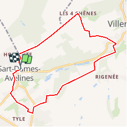
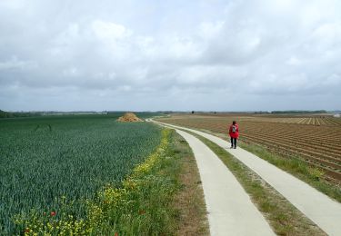
Trail Walking of 8.1 km to be discovered at Wallonia, Walloon Brabant, Villers-la-Ville. This trail is proposed by pascalou73.

Description

Le départ de la rando  à la place de sart dames avelinesdu bois Pigeolet et le châteaux le châtelet .Belle rando familiale à traversant champs et bois.bonne rando

Elevation profile

Photos

Points of interest

Point of interest Genappe - sart dames avelines - Photo
pascalou73
Point of interest Villers-la-Ville - sart dames avelines - Photo
pascalou73
VILLERS-LA-VILLE 
Point of interest Villers-la-Ville - sart dames avelines - Photo
pascalou73
VILLERS-LA-VILLE 
Point of interest Villers-la-Ville - sart dames avelines - Photo
pascalou73
VILLERS-LA-VILLE 
Point of interest Villers-la-Ville - sart dames avelines - Photo
pascalou73
VILLERS-LA-VILLE 

Positioning

Country:
Belgium
Region :
Wallonia
Department/Province :
Walloon Brabant
Municipality :
Villers-la-Ville
Location:
Sart-Dames-Avelines
Start:(UTM)
605734 ; 5602934 (31U) N.

Trails nearby

Trail Walking Villers-la-Ville - RB-Bw-10-raccourci 2 - À travers campagnes et forêts, autour des ruines d’une prestigieuse abbaye - Photo
Walking
PRO

Walking

Difficult
(25)
Villers-la-Ville, Wallonia, Walloon Brabant, Belgium
13.3 km | 16.4 km-effort
3h 44min
Yes
Trail Walking Villers-la-Ville - RB-Bw-10-raccourci 1 - À travers campagnes et forêts, autour des ruines d’une prestigieuse abbaye  - Photo
Walking
PRO

Walking

Very difficult
(12)
Villers-la-Ville, Wallonia, Walloon Brabant, Belgium
24 km | 30 km-effort
6h 43min
Yes
Trail Walking Villers-la-Ville - RB-Bw-10 -À travers campagnes et forêts, autour des ruines d’une prestigieuse abbaye  - Photo
Walking
PRO

Walking

Very difficult
(6)
Villers-la-Ville, Wallonia, Walloon Brabant, Belgium
26 km | 32 km-effort
7h 15min
Yes
Trail Walking Genappe - Genappe - Circuit Natura 2000, des sites qui valent le détour ! - Bw03 - Photo
Walking
GUIDE+

Walking

Medium
(6)
Genappe, Wallonia, Walloon Brabant, Belgium
7.9 km | 9.7 km-effort
2h 6min
Yes
Trail Walking Court-Saint-Étienne - GG2-Bw-22_La-Roche-Blanmont_2021-11-04 - Photo
Walking
PRO

Walking

Medium
(2)
Court-Saint-Étienne, Wallonia, Walloon Brabant, Belgium
21 km | 26 km-effort
5h 51min
No
Trail Walking Villers-la-Ville - Balade forestière à Villers la Ville - Photo
Walking
GUIDE
Desrumaux

Walking

Easy
(5)
Villers-la-Ville, Wallonia, Walloon Brabant, Belgium
11.5 km | 14.1 km-effort
3h 0min
Yes
Trail Walking Court-Saint-Étienne - #240304 - La Roche, bois Ste Catherine et du Sartage - Photo
Walking
Randos Ouvertes

Walking

Medium
(1)
Court-Saint-Étienne, Wallonia, Walloon Brabant, Belgium
5.8 km | 7.6 km-effort
1h 42min
Yes
Trail Walking Villers-la-Ville - BE-Villers-la-Ville - Le Bois Pigeolet et le Châtelet - VLV 7  - Photo
Walking
MicDul

Walking

Easy
(1)
Villers-la-Ville, Wallonia, Walloon Brabant, Belgium
6.6 km | 7.8 km-effort
1h 42min
Yes
Trail On foot Genappe - #200523 - Loncée, Vallée de la Haute Dyle et Houtain*** - Photo
On foot
Randos Ouvertes

On foot

Very easy
(2)
Genappe, Wallonia, Walloon Brabant, Belgium
8.2 km | 9.3 km-effort
2h 0min
Yes


Close
My subscriptions