Trail Walking Perpignan - 66 PERPIGNAN - autour du centre du Monde et la BASSE - Photo

66 PERPIGNAN - autour du centre du Monde et la BASSE

 jeff66
jeff66

User

© OpenStreetMap contributors
Length
Length
6.2 km
Max alt
Max alt
50 m
Uphill gradient
Uphill gradient
44 m
Km-Effort
Km-Effort  
6.8 km
Min alt
Min alt
31 m
Downhill gradient
Downhill gradient
45 m
Boucle
Boucle
Yes
Creation date :
2015-11-23 00:00:00.0
Updated on :
2015-11-23 00:00:00.0

(0 Reviews)

Walking
Walking
1h20
Difficulty : Easy

Scan this QR Code to open this trail in the SityTrail application

FREE GPS app for hiking

Logo SityTrail SityTrail

IGN / Geographical institutes

Download SityTrail from the App Store Download SityTrail from Google Play

Logo SityTrail SityTrail World

The world is yours!

Download SityTrail from the App Store Download SityTrail from Google Play Download SityTrail on Huawei AppGallery

About

Trail Walking of 6.2 km to be discovered at Occitania, Pyrénées-Orientales, Perpignan. This trail is proposed by jeff66.

Description

66 PERPIGNAN, avenue de l'abbé Pierre, en centre Del T mon, avenue du général de Gaule, place de Catalogne, rue du général Legrand, av. des palmiers, rue F. Ferrer, théâtre de l'archipel, av. du général Leclerc, quai F. Battlo, place de la victoire, le Castillet, rue Louis Blanc, rue des marchands, rue de la barre, rue gAlsace Lorraine, place Arago, voral Sébastien Vauban, quai pierre Bourdan, quai Alfred Nobel, quai d'Hanovre, passage sous les voies SNCF le long de la Basse, les jardins de la Basse, rue Antoine Becquerel, rue de LacazeDurhiers, av. dr JL Torreilles,

Elevation profile

Photos

40 photos in total. Please click on a photo to see them all in the gallery.

Positioning

Country:
France
Region :
Occitania
Department/Province :
Pyrénées-Orientales
Municipality :
Perpignan
Location:
Unknown
Start:(UTM)
489974 ; 4726587 (31T) N.

Trails nearby

Trail Walking Saint-Estève - SAINT-ESTEVE 66 - ballade dans le Vignoble de Rivesaltes  - Photo
Walking
jeff66

Walking

Medium
(1)
Saint-Estève, Occitania, Pyrénées-Orientales, France
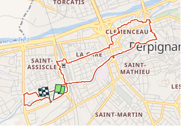
8 km | 8.8 km-effort
1h 23min
Yes
Trail Walking Cabestany - Chemins autour de Cabestany - Photo
Walking
tracegps

Walking

Medium
(2)
Cabestany, Occitania, Pyrénées-Orientales, France
11.8 km | 12.7 km-effort
3h 0min
Yes
Trail Walking Perpignan - Perpignan 01.10.2017  - Photo
Walking
jeff66

Walking

Easy
(1)
Perpignan, Occitania, Pyrénées-Orientales, France
6.7 km | 7.5 km-effort
1h 39min
No
Trail Mountain bike Canohès - canohes - Photo
Mountain bike
haroldtheviking

Mountain bike

Medium
(2)
Canohès, Occitania, Pyrénées-Orientales, France
37 km | 44 km-effort
2h 12min
Yes
Trail Walking Perpignan - Perpignan  - Photo
Walking
ombrabella

Walking

Very easy
Perpignan, Occitania, Pyrénées-Orientales, France
18 km | 19.9 km-effort
2h 23min
No
Trail Walking Perpignan - canal Perpignan  - Photo
Walking
Fildesir

Walking

Very easy
Perpignan, Occitania, Pyrénées-Orientales, France
25 km | 27 km-effort
7h 29min
No
Trail Walking Perpignan - 66 PERPIGNAN, quartier MAV au Bas Vernet  - Photo
Walking
jeff66

Walking

Easy
Perpignan, Occitania, Pyrénées-Orientales, France
10.7 km | 11.8 km-effort
1h 45min
Yes
Trail Walking Perpignan - 66 Perpignan Panchot centre bas Vernet centre del mon - Photo
Walking
jeff66

Walking

Easy
Perpignan, Occitania, Pyrénées-Orientales, France
8.6 km | 9.3 km-effort
1h 29min
Yes
Trail Walking Bompas - 66 BOMPAS - itinéraire partagé piétions cycliste en bord de Tet, berge Têt, Bas Vernet, retour par les canaux et centre ville de BOMPAS  - Photo
Walking
jeff66

Walking

Medium
Bompas, Occitania, Pyrénées-Orientales, France
13.4 km | 14.2 km-effort
2h 23min
Yes


Close
My subscriptions