Trail Walking Perpignan - 66 PERPIGNAN, du moulin à vent A Las Cobas, par saint Vicens et Saint Gauderique - Photo

66 PERPIGNAN, du moulin à vent A Las Cobas, par saint Vicens et Saint Gauderique

 jeff66
jeff66

User

© OpenStreetMap contributors
Length
Length
8.3 km
Max alt
Max alt
57 m
Uphill gradient
Uphill gradient
71 m
Km-Effort
Km-Effort  
9.3 km
Min alt
Min alt
35 m
Downhill gradient
Downhill gradient
70 m
Boucle
Boucle
Yes
Creation date :
2015-12-08 00:00:00.0
Updated on :
2015-12-08 00:00:00.0

(0 Reviews)

Walking
Walking
1h38
Difficulty : Easy

Scan this QR Code to open this trail in the SityTrail application

FREE GPS app for hiking

Logo SityTrail SityTrail

IGN / Geographical institutes

Download SityTrail from the App Store Download SityTrail from Google Play

Logo SityTrail SityTrail World

The world is yours!

Download SityTrail from the App Store Download SityTrail from Google Play Download SityTrail on Huawei AppGallery

About

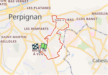
Trail Walking of 8.3 km to be discovered at Occitania, Pyrénées-Orientales, Perpignan. This trail is proposed by jeff66.

Description

66 PERPIGNAN, Moulin à vent,  Bld du Foment de la Sardane, square st Marsel, passage de Montferrer, de Corsavy, jardin A.Maillol, rue du Racou, rue de Canet, rue de St ANDRE, av. G Guynemer, rue des Barcarolles, rue des sérénades, av. de la côte vermeille et A. Camus, lycée Jean Lurcat, rue nature, rues E.Degas, des 7 primadie, Rubens, cimetière de l'est, rues a Maillol, G.Violet, du genêt d'or, de les Coves, av. des tamaris, Rues des courlis, du corail, P. De Montreuil, Delorme, Soufflot, Lescot, Salomon de Brousse, Parc St Vincens éco jardin, rues J. Delacretelle et A.Ansaldi, rues W.Shaskepeare, rue de Port- Vendres, Bld du Foment de la Sardane, rues montescot, Palau-Del-Vidre, du vilar, et de St nazaire

Elevation profile

Photos

39 photos in total. Please click on a photo to see them all in the gallery.

Positioning

Country:
France
Region :
Occitania
Department/Province :
Pyrénées-Orientales
Municipality :
Perpignan
Location:
Unknown
Start:(UTM)
492123 ; 4725640 (31T) N.

Trails nearby

Trail Walking Saint-Estève - SAINT-ESTEVE 66 - ballade dans le Vignoble de Rivesaltes  - Photo
Walking
jeff66

Walking

Medium
(1)
Saint-Estève, Occitania, Pyrénées-Orientales, France
8 km | 8.8 km-effort
1h 23min
Yes
Trail Walking Cabestany - Chemins autour de Cabestany - Photo
Walking
tracegps

Walking

Medium
(2)
Cabestany, Occitania, Pyrénées-Orientales, France
11.8 km | 12.7 km-effort
3h 0min
Yes
Trail Walking Perpignan - Perpignan 01.10.2017  - Photo
Walking
jeff66

Walking

Easy
(1)
Perpignan, Occitania, Pyrénées-Orientales, France
6.7 km | 7.5 km-effort
1h 39min
No
Trail Walking Villeneuve-de-la-Raho - 66 VILLENEUVE-DE-LA-RAHO - grand tour périphérique du lac par les lignes de crêtes  - Photo
Walking
jeff66

Walking

Easy
(2)
Villeneuve-de-la-Raho, Occitania, Pyrénées-Orientales, France
10 km | 11.5 km-effort
1h 44min
Yes
Trail Walking Saleilles - 66 SALEILLES - St-NAZAIRE, entre FOSSEILLE et REART - Photo
Walking
jeff66

Walking

Easy
(1)
Saleilles, Occitania, Pyrénées-Orientales, France
7.3 km | 7.7 km-effort
1h 8min
Yes
Trail Walking Perpignan - Perpignan  - Photo
Walking
ombrabella

Walking

Very easy
Perpignan, Occitania, Pyrénées-Orientales, France
18 km | 19.9 km-effort
2h 23min
No
Trail Walking Perpignan - canal Perpignan  - Photo
Walking
Fildesir

Walking

Very easy
Perpignan, Occitania, Pyrénées-Orientales, France
25 km | 27 km-effort
7h 29min
No
Trail Walking Perpignan - 66 PERPIGNAN, quartier MAV au Bas Vernet  - Photo
Walking
jeff66

Walking

Easy
Perpignan, Occitania, Pyrénées-Orientales, France
10.7 km | 11.8 km-effort
1h 45min
Yes
Trail Walking Perpignan - 66 Perpignan Panchot centre bas Vernet centre del mon - Photo
Walking
jeff66

Walking

Easy
Perpignan, Occitania, Pyrénées-Orientales, France
8.6 km | 9.3 km-effort
1h 29min
Yes


Close
My subscriptions