![](/images/other/stat-length.png)
![Trail Cycle Guilherand-Granges - boucle cycliste - Photo](https://media.geolcdn.com/t/1900/400/ext.pjpeg?maxdim=2&url=https%3A%2F%2Fstatic1.geolcdn.com%2Fsiteimages%2Fupload%2Ffiles%2F1524743154velo.jpg)
boucle cycliste
aps07
User
![Length](/images/other/stat-length.png)
Length
33 km
![Max alt](https://static1.geolcdn.com/siteimages/upload/files/1508320355ic_sort_altitude_max_24dp.png)
Max alt
436 m
![Uphill gradient](https://static1.geolcdn.com/siteimages/upload/files/1508320355ic_sort_den_pos_24dp.png)
Uphill gradient
737 m
![Km-Effort](/images/other/stat-length.png)
Km-Effort
43 km
![Min alt](https://static1.geolcdn.com/siteimages/upload/files/1508320355ic_sort_altitude_min_24dp.png)
Min alt
108 m
![Downhill gradient](https://static1.geolcdn.com/siteimages/upload/files/1508320355ic_sort_den_neg_24dp.png)
Downhill gradient
740 m
![Boucle](https://static1.geolcdn.com/siteimages/upload/files/16400158638029165_repeat_loop_refresh_sync_direction_icon.png)
Boucle
No
Creation date :
2016-03-09 00:00:00.0
Updated on :
2016-03-09 00:00:00.0
![Cycle](https://static1.geolcdn.com/sitytour/trail-icons/200.png)
2h26
Difficulty : Medium
![Scan this QR Code to open this trail in the SityTrail application](https://capi.geolives.com/qq0zvz2zws4bq2lad0pu/sitytour/trails/531189/qr.png?size=200)
FREE GPS app for hiking
About
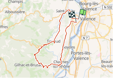
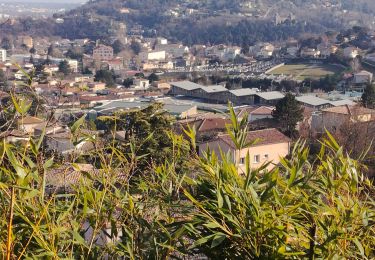
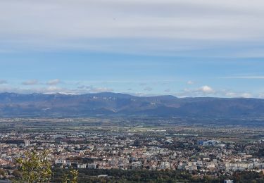
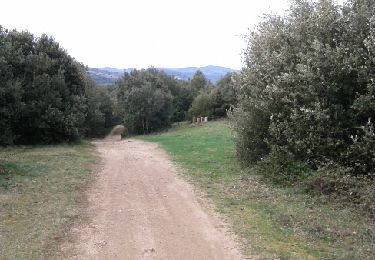
Trail Cycle of 33 km to be discovered at Auvergne-Rhône-Alpes, Ardèche, Guilherand-Granges. This trail is proposed by aps07.
Description
tracé extrait du parcours de 200 kms de la boucle cycliste internationale ' (180 coureurs pro )dénommé "course classic sud-ardeche " du 270216 (guilherand- guilherand .
Positioning
Country:
France
Region :
Auvergne-Rhône-Alpes
Department/Province :
Ardèche
Municipality :
Guilherand-Granges
Location:
Unknown
Start:(Dec)
Start:(UTM)
647687 ; 4977108 (31T) N.
Comments
Trails nearby
![Trail Mountain bike Saint-Péray - Boucle VTT autour de Saint Péray - Photo](https://media.geolcdn.com/t/375/260/ext.jpg?maxdim=2&url=https%3A%2F%2Fstatic1.geolcdn.com%2Fsiteimages%2Fupload%2Ffiles%2F1524743154velo.jpg)
![Mountain bike Mountain bike](https://static1.geolcdn.com/sitytour/trail-icons/202.png)
Boucle VTT autour de Saint Péray
Mountain bike
Difficult
(5)
Saint-Péray,
Auvergne-Rhône-Alpes,
Ardèche,
France
![](/images/other/stat-length.png)
31 km | 41 km-effort
2h 0min
![](https://static1.geolcdn.com/siteimages/upload/files/16400158638029165_repeat_loop_refresh_sync_direction_icon.png)
Yes
![Trail Walking Toulaud - Château de Crussol par Meyret - Photo](https://media.geolcdn.com/t/375/260/ext.jpg?maxdim=2&url=https%3A%2F%2Fmedia.geolcdn.com%2Ff%2F8477a480-9227-4102-b2db-afb6f5fa490e.jpg)
![Walking Walking](https://static1.geolcdn.com/sitytour/trail-icons/101.png)
Château de Crussol par Meyret
Walking
Medium
(1)
Toulaud,
Auvergne-Rhône-Alpes,
Ardèche,
France
![](/images/other/stat-length.png)
7.6 km | 11.1 km-effort
3h 14min
![](https://static1.geolcdn.com/siteimages/upload/files/16400158638029165_repeat_loop_refresh_sync_direction_icon.png)
Yes
![Trail Walking Cornas - De Cornas à la Borne - Photo](https://media.geolcdn.com/t/375/260/ext.jpg?maxdim=2&url=https%3A%2F%2Fstatic1.geolcdn.com%2Fsiteimages%2Fupload%2Ffiles%2F1553511878bg_sport_marche.png)
![Walking Walking](https://static1.geolcdn.com/sitytour/trail-icons/101.png)
De Cornas à la Borne
Walking
Difficult
(1)
Cornas,
Auvergne-Rhône-Alpes,
Ardèche,
France
![](/images/other/stat-length.png)
12.3 km | 18.3 km-effort
4h 51min
![](https://static1.geolcdn.com/siteimages/upload/files/16400158638029165_repeat_loop_refresh_sync_direction_icon.png)
Yes
![Trail Walking Saint-Péray - N_ST PERAY 07130 Baume des Bois - Crussol - Photo](https://media.geolcdn.com/t/375/260/ext.jpg?maxdim=2&url=https%3A%2F%2Fstatic1.geolcdn.com%2Fsiteimages%2Fupload%2Ffiles%2F1553511878bg_sport_marche.png)
![Walking Walking](https://static1.geolcdn.com/sitytour/trail-icons/101.png)
N_ST PERAY 07130 Baume des Bois - Crussol
Walking
Easy
(2)
Saint-Péray,
Auvergne-Rhône-Alpes,
Ardèche,
France
![](/images/other/stat-length.png)
4.2 km | 6.8 km-effort
1h 40min
![](https://static1.geolcdn.com/siteimages/upload/files/16400158638029165_repeat_loop_refresh_sync_direction_icon.png)
Yes
![Trail Walking Toulaud - l'Embroye - Photo](https://media.geolcdn.com/t/375/260/ext.jpg?maxdim=2&url=https%3A%2F%2Fmedia.geolcdn.com%2Ff%2Fcb947bb6-7dc1-43ba-a067-9c4f7f015103.jpg)
![Walking Walking](https://static1.geolcdn.com/sitytour/trail-icons/101.png)
l'Embroye
Walking
Medium
Toulaud,
Auvergne-Rhône-Alpes,
Ardèche,
France
![](/images/other/stat-length.png)
12.6 km | 19.6 km-effort
6h 9min
![](https://static1.geolcdn.com/siteimages/upload/files/16400158638029165_repeat_loop_refresh_sync_direction_icon.png)
No
![Trail Walking Saint-Péray - St Peray - Photo](https://media.geolcdn.com/t/375/260/ext.jpg?maxdim=2&url=https%3A%2F%2Fmedia.geolcdn.com%2Ff%2Ff4637115-cc7a-4f13-bfda-10680f079d1e.jpg)
![Walking Walking](https://static1.geolcdn.com/sitytour/trail-icons/101.png)
St Peray
Walking
Difficult
Saint-Péray,
Auvergne-Rhône-Alpes,
Ardèche,
France
![](/images/other/stat-length.png)
7.6 km | 12.4 km-effort
2h 49min
![](https://static1.geolcdn.com/siteimages/upload/files/16400158638029165_repeat_loop_refresh_sync_direction_icon.png)
Yes
![Trail Walking Saint-Péray - saint peray - Photo](https://media.geolcdn.com/t/375/260/ext.jpg?maxdim=2&url=https%3A%2F%2Fmedia.geolcdn.com%2Ff%2F0ac7a899-a3f6-43d8-8e6c-a6c828bfc257.jpg)
![Walking Walking](https://static1.geolcdn.com/sitytour/trail-icons/101.png)
saint peray
Walking
Difficult
(1)
Saint-Péray,
Auvergne-Rhône-Alpes,
Ardèche,
France
![](/images/other/stat-length.png)
15 km | 23 km-effort
5h 19min
![](https://static1.geolcdn.com/siteimages/upload/files/16400158638029165_repeat_loop_refresh_sync_direction_icon.png)
Yes
![Trail Walking Saint-Péray - Le château de Crussol et ses crêtes - Photo](https://media.geolcdn.com/t/375/260/ext.jpg?maxdim=2&url=https%3A%2F%2Fmedia.geolcdn.com%2Ff%2Fab0e5341-d878-44c5-9329-3ce4a540f9aa.jpg)
![Walking Walking](https://static1.geolcdn.com/sitytour/trail-icons/101.png)
Le château de Crussol et ses crêtes
Walking
Easy
Saint-Péray,
Auvergne-Rhône-Alpes,
Ardèche,
France
![](/images/other/stat-length.png)
9.9 km | 14.1 km-effort
2h 27min
![](https://static1.geolcdn.com/siteimages/upload/files/16400158638029165_repeat_loop_refresh_sync_direction_icon.png)
Yes
![Trail Mountain bike Guilherand-Granges - guilherand-st peray-tracol-st peray-Cornas-guilherand - Photo](https://media.geolcdn.com/t/375/260/ext.jpg?maxdim=2&url=https%3A%2F%2Fservices.sitytrail.com%2FGeolivesWS%2FDownloadMedia.ashx%3FTrailID%3D400229%26Media%3Dfix__20150326105918.jpg)
![Mountain bike Mountain bike](https://static1.geolcdn.com/sitytour/trail-icons/202.png)
guilherand-st peray-tracol-st peray-Cornas-guilherand
Mountain bike
Medium
Guilherand-Granges,
Auvergne-Rhône-Alpes,
Ardèche,
France
![](/images/other/stat-length.png)
30 km | 36 km-effort
3h 1min
![](https://static1.geolcdn.com/siteimages/upload/files/16400158638029165_repeat_loop_refresh_sync_direction_icon.png)
Yes