Trail Walking Sorède - 66 SOREDE - ND du château d'Ultréra le 24.09.2016  - Photo

66 SOREDE - ND du château d'Ultréra le 24.09.2016

 jeff66
jeff66

User

© OpenStreetMap contributors
Length
Length
13.9 km
Max alt
Max alt
550 m
Uphill gradient
Uphill gradient
528 m
Km-Effort
Km-Effort  
21 km
Min alt
Min alt
81 m
Downhill gradient
Downhill gradient
529 m
Boucle
Boucle
Yes
Creation date :
2016-09-24 00:00:00.0
Updated on :
2016-09-24 00:00:00.0

(1 Reviews)

Walking
Walking
2h57
Difficulty : Medium

Scan this QR Code to open this trail in the SityTrail application

FREE GPS app for hiking

Logo SityTrail SityTrail

IGN / Geographical institutes

Download SityTrail from the App Store Download SityTrail from Google Play

Logo SityTrail SityTrail World

The world is yours!

Download SityTrail from the App Store Download SityTrail from Google Play Download SityTrail on Huawei AppGallery

About

Trail Walking of 13.9 km to be discovered at Occitania, Pyrénées-Orientales, Sorède. This trail is proposed by jeff66.

Description

66 SOREDE - ND du château d'Ultréra - château d'Ultréra - PUIG de Nalt - MAS de Ca - LA RIVIERE de SOREDE - Le Tassio - rue du Veinat - le 24.09.2016

Elevation profile

Positioning

Country:
France
Region :
Occitania
Department/Province :
Pyrénées-Orientales
Municipality :
Sorède
Location:
Unknown
Start:(UTM)
496478 ; 4708457 (31T) N.

Comments

Please log in to post a review or rate the element


Trails nearby

Trail Walking Laroque-des-Albères - 66 LAROQUE DES ALBERES (maison) SOREDE, par pistes DFCI AL12 et 19, mas del Ca et mas Manere, Itin.16  - Photo
Walking
jeff66

Walking

Medium
(1)
Laroque-des-Albères, Occitania, Pyrénées-Orientales, France
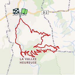
11.2 km | 15.3 km-effort
2h 5min
Yes
Trail Walking Laroque-des-Albères - 66 SOREDE, LAROQUE DES ALBERES, chemins des Mas - Photo
Walking
jeff66

Walking

Medium
(1)
Laroque-des-Albères, Occitania, Pyrénées-Orientales, France
7 km | 8.9 km-effort
1h 22min
Yes
Trail Walking Saint-André - 66 SAINT-ANDRE - SOREDE - chapelle Saint Ferreol de la Pava  - Photo
Walking
jeff66

Walking

Medium
(1)
Saint-André, Occitania, Pyrénées-Orientales, France
14.2 km | 16.9 km-effort
2h 25min
Yes
Trail Walking Palau-del-Vidre - PALAU-DEL-VIDRE 66 - Boucle de Villeclare - promenade dans les vergers et cultures maraîchères  - Photo
Walking
jeff66

Walking

Easy
(2)
Palau-del-Vidre, Occitania, Pyrénées-Orientales, France
7.5 km | 7.9 km-effort
1h 16min
Yes
Trail Walking Sorède - Utrera Font Miracles T - Photo
Walking
force

Walking

Medium
(1)
Sorède, Occitania, Pyrénées-Orientales, France
10.7 km | 17.6 km-effort
3h 50min
Yes
Trail Walking Sorède - 577. 11km sorede roc des medes  - Photo
Walking
Erius

Walking

Medium
(1)
Sorède, Occitania, Pyrénées-Orientales, France
10.5 km | 18.2 km-effort
3h 42min
Yes
Trail Walking Laroque-des-Albères - Col-Ullat Pic-aureille_Terrain - Photo
Walking
force

Walking

Medium
(1)
Laroque-des-Albères, Occitania, Pyrénées-Orientales, France
11.2 km | 23 km-effort
4h 47min
Yes
Trail On foot Sorède - Vallée Heureuse - Château d'Ultrera - Photo
On foot
PRO

On foot

Easy
Sorède, Occitania, Pyrénées-Orientales, France
10.9 km | 19.4 km-effort
4h 23min
Yes
Trail Walking Brouilla - RP66 BROUILLA - BANYULS DELS ASPRES - par les bords de Tech et Vignobles - le 31.03.2017 - Photo
Walking
jeff66

Walking

Easy
(3)
Brouilla, Occitania, Pyrénées-Orientales, France
7.5 km | 8.3 km-effort
1h 26min
Yes


Close
My subscriptions