Trail Walking Lamanère - Tours de Cabrens - Photo
 jcmartin
jcmartin

User

© OpenStreetMap contributors
Length
Length
12 km
Max alt
Max alt
1313 m
Uphill gradient
Uphill gradient
564 m
Km-Effort
Km-Effort  
19.6 km
Min alt
Min alt
783 m
Downhill gradient
Downhill gradient
565 m
Boucle
Boucle
Yes
Creation date :
2016-11-04 00:00:00.0
Updated on :
2016-11-04 00:00:00.0

(0 Reviews)

Walking
Walking
4h14
Difficulty : Medium

Scan this QR Code to open this trail in the SityTrail application

FREE GPS app for hiking

Logo SityTrail SityTrail

IGN / Geographical institutes

Download SityTrail from the App Store Download SityTrail from Google Play

Logo SityTrail SityTrail World

The world is yours!

Download SityTrail from the App Store Download SityTrail from Google Play Download SityTrail on Huawei AppGallery

About

Trail Walking of 12 km to be discovered at Occitania, Pyrénées-Orientales, Lamanère. This trail is proposed by jcmartin.

Description

a certains endroits le sentier balisé est un peu différent du tracé de la carte IGN mais pas de soucis il suffit de suivre le balisage qui est très bien fait

Elevation profile

Photos

Positioning

Country:
France
Region :
Occitania
Department/Province :
Pyrénées-Orientales
Municipality :
Lamanère
Location:
Unknown
Start:(UTM)
460450 ; 4689873 (31T) N.

Trails nearby

Trail Walking Lamanère - lamanere-coral_T - Photo
Walking
force

Walking

Very easy
Lamanère, Occitania, Pyrénées-Orientales, France
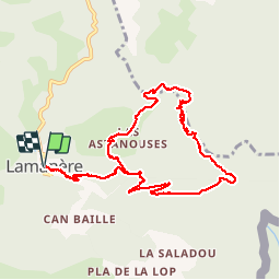
14.9 km | 25 km-effort
5h 18min
Yes
Trail Walking Lamanère - Lamanere_PuigDeComaNegra_T - Photo
Walking
force

Walking

Very easy
(1)
Lamanère, Occitania, Pyrénées-Orientales, France
15.9 km | 28 km-effort
5h 48min
Yes
Trail Walking Serralongue - serralongue Tours de Cabrens_T - Photo
Walking
force

Walking

Medium
Serralongue, Occitania, Pyrénées-Orientales, France
13.3 km | 22 km-effort
4h 39min
Yes
Trail Walking Prats-de-Mollo-la-Preste - 5 et 6 rando sur 2 jours  - Photo
Walking
ricou1964

Walking

Very difficult
Prats-de-Mollo-la-Preste, Occitania, Pyrénées-Orientales, France
32 km | 49 km-effort
9h 39min
Yes
Trail Walking Lamanère - Lamanere - Photo
Walking
jcmartin

Walking

Medium
Lamanère, Occitania, Pyrénées-Orientales, France
16.4 km | 26 km-effort
5h 20min
Yes
Trail Mountain bike Prats-de-Mollo-la-Preste - Espace VTT FFC Haut Vallespir - circuit n° 17 - Raid Transfrontalier - Photo
Mountain bike
tracegps

Mountain bike

Very difficult
Prats-de-Mollo-la-Preste, Occitania, Pyrénées-Orientales, France
41 km | 64 km-effort
4h 30min
Yes
Trail Mountain bike Serralongue - Espace VTT FFC Haut Vallespir - circuit n° 11 - De Serralongue à Falgos - Photo
Mountain bike
tracegps

Mountain bike

Difficult
Serralongue, Occitania, Pyrénées-Orientales, France
28 km | 39 km-effort
2h 30min
Yes
Trail Mountain bike Prats-de-Mollo-la-Preste - Espace VTT FFC Haut Vallespir - circuit n° 3 - La Chapelle Ste Marguerite de Prats de Mollo - Photo
Mountain bike
tracegps

Mountain bike

Easy
Prats-de-Mollo-la-Preste, Occitania, Pyrénées-Orientales, France
12.6 km | 17 km-effort
1h 15min
Yes
Trail Walking Lamanère - 2 - Photo
Walking
ricou1964

Walking

Difficult
Lamanère, Occitania, Pyrénées-Orientales, France
16.7 km | 27 km-effort
5h 2min
Yes


Close
My subscriptions