Trail Walking Chastel-Arnaud - Les Auberts La Laveuse - Photo
 collot
collot

User

© OpenStreetMap contributors
Length
Length
11.8 km
Max alt
Max alt
1373 m
Uphill gradient
Uphill gradient
886 m
Km-Effort
Km-Effort  
24 km
Min alt
Min alt
623 m
Downhill gradient
Downhill gradient
891 m
Boucle
Boucle
Yes
Creation date :
2017-03-06 00:00:00.0
Updated on :
2017-03-06 00:00:00.0

(0 Reviews)

Walking
Walking
4h50
Difficulty : Difficult

Scan this QR Code to open this trail in the SityTrail application

FREE GPS app for hiking

Logo SityTrail SityTrail

IGN / Geographical institutes

Download SityTrail from the App Store Download SityTrail from Google Play

Logo SityTrail SityTrail World

The world is yours!

Download SityTrail from the App Store Download SityTrail from Google Play Download SityTrail on Huawei AppGallery

About

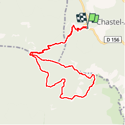
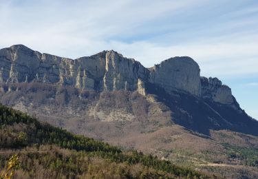
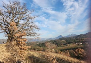
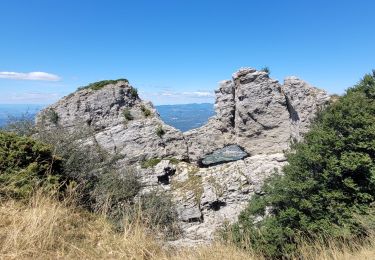
Trail Walking of 11.8 km to be discovered at Auvergne-Rhône-Alpes, Drôme, Chastel-Arnaud. This trail is proposed by collot.

Description

Boucle Les Auberts, Pas de la Motte, La Laveuse et refuge des Girards, enfin retour.

Elevation profile

Positioning

Country:
France
Region :
Auvergne-Rhône-Alpes
Department/Province :
Drôme
Municipality :
Chastel-Arnaud
Location:
Unknown
Start:(UTM)
673481 ; 4947861 (31T) N.

Trails nearby

Trail Walking Saou - saou.les 3 becs - Photo
Walking
Lemichmich

Walking

Difficult
(3)
Saou, Auvergne-Rhône-Alpes, Drôme, France
22 km | 40 km-effort
6h 46min
Yes
Trail Walking La Chaudière - Les 3 Becs - Photo
Walking
Noiraude

Walking

Medium
(1)
La Chaudière, Auvergne-Rhône-Alpes, Drôme, France
10.3 km | 21 km-effort
5h 37min
Yes
Trail Walking La Chaudière - La chaudiere - chapelle des Sadoux - Photo
Walking
bob2023

Walking

Very easy
(2)
La Chaudière, Auvergne-Rhône-Alpes, Drôme, France
11.1 km | 18.2 km-effort
3h 47min
Yes
Trail Walking Saou - Les 3 Becs, le Veyou, le Signal et Rochecourbe - Photo
Walking
tracegps

Walking

Difficult
(3)
Saou, Auvergne-Rhône-Alpes, Drôme, France
18.5 km | 36 km-effort
8h 0min
Yes
Trail Mountain bike Saillans - Grande Traversée des PréAlpes à VTT : variante Saillans - Montmorin - Photo
Mountain bike
tracegps

Mountain bike

Very difficult
(1)
Saillans, Auvergne-Rhône-Alpes, Drôme, France
74 km | 113 km-effort
11h 0min
No
Trail Walking La Chaudière - les trois becs - Photo
Walking
GUIDE
amiral13

Walking

Medium
La Chaudière, Auvergne-Rhône-Alpes, Drôme, France
11.7 km | 23 km-effort
6h 25min
Yes
Trail Walking Saint-Sauveur-en-Diois - saint sauveur en diois - Photo
Walking
Fanchon_24

Walking

Very easy
Saint-Sauveur-en-Diois, Auvergne-Rhône-Alpes, Drôme, France
5 km | 6.7 km-effort
1h 46min
Yes
Trail Walking Aubenasson - saint Michel Aubenasson - Photo
Walking
Fanchon_24

Walking

Medium
Aubenasson, Auvergne-Rhône-Alpes, Drôme, France
19.7 km | 24 km-effort
3h 45min
No
Trail Walking La Chaudière - 070823 Boucle des 3 Becs - Photo
Walking
mzonzon05

Walking

Very difficult
La Chaudière, Auvergne-Rhône-Alpes, Drôme, France
11.4 km | 23 km-effort
4h 58min
Yes


Close
My subscriptions