![](/images/other/stat-length.png)
![Trail Other activity Nantheuil - Nantheuil vers Castilloux 11km - Photo](https://media.geolcdn.com/t/1900/400/ext.pjpeg?maxdim=2&url=https%3A%2F%2Fstatic1.geolcdn.com%2Fsiteimages%2Fupload%2Ffiles%2F1545311037marcheuse_200dpi.jpg)
Nantheuil vers Castilloux 11km
YV24
User
![Length](/images/other/stat-length.png)
Length
11 km
![Max alt](https://static1.geolcdn.com/siteimages/upload/files/1508320355ic_sort_altitude_max_24dp.png)
Max alt
268 m
![Uphill gradient](https://static1.geolcdn.com/siteimages/upload/files/1508320355ic_sort_den_pos_24dp.png)
Uphill gradient
234 m
![Km-Effort](/images/other/stat-length.png)
Km-Effort
14.2 km
![Min alt](https://static1.geolcdn.com/siteimages/upload/files/1508320355ic_sort_altitude_min_24dp.png)
Min alt
159 m
![Downhill gradient](https://static1.geolcdn.com/siteimages/upload/files/1508320355ic_sort_den_neg_24dp.png)
Downhill gradient
233 m
![Boucle](https://static1.geolcdn.com/siteimages/upload/files/16400158638029165_repeat_loop_refresh_sync_direction_icon.png)
Boucle
Yes
Creation date :
2017-03-29 00:00:00.0
Updated on :
2022-01-31 17:09:03.529
![Other activity](https://static1.geolcdn.com/sitytour/trail-icons/900.png)
2h47
Difficulty : Unknown
![Scan this QR Code to open this trail in the SityTrail application](https://capi.geolives.com/qq0zvz2zws4bq2lad0pu/sitytour/trails/721939/qr.png?size=200)
FREE GPS app for hiking
About
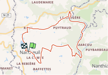
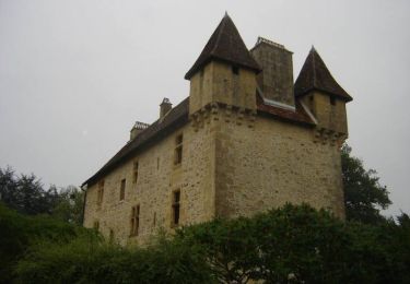
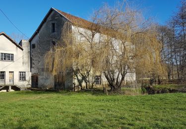
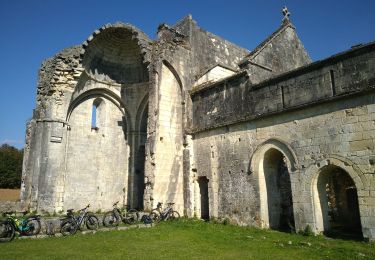
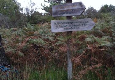
Trail Other activity of 11 km to be discovered at New Aquitaine, Dordogne, Nantheuil. This trail is proposed by YV24.
Description
Boucle spéciale, selon PDIPR n°5 carto Thiviers et liaison verte.
Variée, vallonnée, peu de route,ornières possible après fortes pluies.
Positioning
Country:
France
Region :
New Aquitaine
Department/Province :
Dordogne
Municipality :
Nantheuil
Location:
Unknown
Start:(Dec)
Start:(UTM)
339153 ; 5030929 (31T) N.
Comments
Trails nearby
![Trail Walking Saint-Sulpice-d'Excideuil - Les boucles la Caraque/le Ravillou - Saint-Sulpice-d'Excideuil - Photo](https://media.geolcdn.com/t/375/260/ext.jpg?maxdim=2&url=https%3A%2F%2Fservices.sitytrail.com%2FGeolivesWS%2FDownloadMedia.ashx%3FTrailID%3D112559%26Media%3D10867_6.jpg)
![Walking Walking](https://static1.geolcdn.com/sitytour/trail-icons/101.png)
Les boucles la Caraque/le Ravillou - Saint-Sulpice-d'Excideuil
Walking
Medium
(1)
Saint-Sulpice-d'Excideuil,
New Aquitaine,
Dordogne,
France
![](/images/other/stat-length.png)
7.7 km | 10 km-effort
2h 0min
![](https://static1.geolcdn.com/siteimages/upload/files/16400158638029165_repeat_loop_refresh_sync_direction_icon.png)
Yes
![Trail Walking Corgnac-sur-l'Isle - Boucle de Puyfebert à Corgnac sur L'isle (24) - Photo](https://media.geolcdn.com/t/375/260/ext.jpg?maxdim=2&url=https%3A%2F%2Fmedia.geolcdn.com%2Ff%2F473ca2ea-b417-4ef5-b016-acee12c3b097.jpg)
![Walking Walking](https://static1.geolcdn.com/sitytour/trail-icons/101.png)
Boucle de Puyfebert à Corgnac sur L'isle (24)
Walking
Very easy
(1)
Corgnac-sur-l'Isle,
New Aquitaine,
Dordogne,
France
![](/images/other/stat-length.png)
13.4 km | 16.5 km-effort
3h 27min
![](https://static1.geolcdn.com/siteimages/upload/files/16400158638029165_repeat_loop_refresh_sync_direction_icon.png)
Yes
![Trail Walking Saint-Sulpice-d'Excideuil - St Sulpice Excideuil Cavaire + Ravillou 12km - Photo](https://media.geolcdn.com/t/375/260/ext.jpg?maxdim=2&url=https%3A%2F%2Fstatic1.geolcdn.com%2Fsiteimages%2Fupload%2Ffiles%2F1553511878bg_sport_marche.png)
![Walking Walking](https://static1.geolcdn.com/sitytour/trail-icons/101.png)
St Sulpice Excideuil Cavaire + Ravillou 12km
Walking
Easy
(1)
Saint-Sulpice-d'Excideuil,
New Aquitaine,
Dordogne,
France
![](/images/other/stat-length.png)
11.3 km | 14.4 km-effort
3h 5min
![](https://static1.geolcdn.com/siteimages/upload/files/16400158638029165_repeat_loop_refresh_sync_direction_icon.png)
Yes
![Trail Mountain bike Thiviers - Thiviers vtt - Photo](https://media.geolcdn.com/t/375/260/ext.jpg?maxdim=2&url=https%3A%2F%2Fmedia.geolcdn.com%2Ff%2Fdf34d907-768b-4b26-a7b5-5ec7cdc86a99.jpg)
![Mountain bike Mountain bike](https://static1.geolcdn.com/sitytour/trail-icons/202.png)
Thiviers vtt
Mountain bike
Very easy
Thiviers,
New Aquitaine,
Dordogne,
France
![](/images/other/stat-length.png)
48 km | 58 km-effort
6h 2min
![](https://static1.geolcdn.com/siteimages/upload/files/16400158638029165_repeat_loop_refresh_sync_direction_icon.png)
Yes
![Trail Walking Eyzerac - La Servolle 2 - Photo](https://media.geolcdn.com/t/375/260/ext.jpg?maxdim=2&url=https%3A%2F%2Fservices.sitytrail.com%2FGeolivesWS%2FDownloadMedia.ashx%3FTrailID%3D226050%26Media%3D20131008110344.jpg)
![Walking Walking](https://static1.geolcdn.com/sitytour/trail-icons/101.png)
La Servolle 2
Walking
Easy
Eyzerac,
New Aquitaine,
Dordogne,
France
![](/images/other/stat-length.png)
12.4 km | 14.9 km-effort
3h 16min
![](https://static1.geolcdn.com/siteimages/upload/files/16400158638029165_repeat_loop_refresh_sync_direction_icon.png)
Yes
![Trail Walking Nantheuil - Nantheuil route - Photo](https://media.geolcdn.com/t/375/260/ext.jpg?maxdim=2&url=https%3A%2F%2Fstatic1.geolcdn.com%2Fsiteimages%2Fupload%2Ffiles%2F1553511878bg_sport_marche.png)
![Walking Walking](https://static1.geolcdn.com/sitytour/trail-icons/101.png)
Nantheuil route
Walking
Easy
Nantheuil,
New Aquitaine,
Dordogne,
France
![](/images/other/stat-length.png)
8 km | 9.6 km-effort
1h 39min
![](https://static1.geolcdn.com/siteimages/upload/files/16400158638029165_repeat_loop_refresh_sync_direction_icon.png)
No
![Trail Walking Nantheuil - Boucle observatoire allongée Nantheuil - Photo](https://media.geolcdn.com/t/375/260/ext.jpg?maxdim=2&url=https%3A%2F%2Fmedia.geolcdn.com%2Ff%2Fefe1fbe8-4080-47ca-9be9-dfb6227d2dee.jpg)
![Walking Walking](https://static1.geolcdn.com/sitytour/trail-icons/101.png)
Boucle observatoire allongée Nantheuil
Walking
Medium
Nantheuil,
New Aquitaine,
Dordogne,
France
![](/images/other/stat-length.png)
11.2 km | 14.2 km-effort
2h 52min
![](https://static1.geolcdn.com/siteimages/upload/files/16400158638029165_repeat_loop_refresh_sync_direction_icon.png)
Yes
![Trail Walking Eyzerac - Eyzerat - Photo](https://media.geolcdn.com/t/375/260/ext.jpg?maxdim=2&url=https%3A%2F%2Fstatic1.geolcdn.com%2Fsiteimages%2Fupload%2Ffiles%2F1553511878bg_sport_marche.png)
![Walking Walking](https://static1.geolcdn.com/sitytour/trail-icons/101.png)
Eyzerat
Walking
Medium
Eyzerac,
New Aquitaine,
Dordogne,
France
![](/images/other/stat-length.png)
12.8 km | 15.7 km-effort
3h 3min
![](https://static1.geolcdn.com/siteimages/upload/files/16400158638029165_repeat_loop_refresh_sync_direction_icon.png)
Yes
![Trail Walking Sarrazac - tacot de Nantheuil - Photo](https://media.geolcdn.com/t/375/260/ext.jpg?maxdim=2&url=https%3A%2F%2Fstatic1.geolcdn.com%2Fsiteimages%2Fupload%2Ffiles%2F1553511878bg_sport_marche.png)
![Walking Walking](https://static1.geolcdn.com/sitytour/trail-icons/101.png)
tacot de Nantheuil
Walking
Very easy
Sarrazac,
New Aquitaine,
Dordogne,
France
![](/images/other/stat-length.png)
7.2 km | 8.5 km-effort
1h 21min
![](https://static1.geolcdn.com/siteimages/upload/files/16400158638029165_repeat_loop_refresh_sync_direction_icon.png)
Yes