Trail Walking Saint-Ay - Itineraire Gaston Couté 1899 - Photo

Itineraire Gaston Couté 1899

 sash28
sash28

User

© OpenStreetMap contributors
Length
Length
313 km
Max alt
Max alt
196 m
Uphill gradient
Uphill gradient
2670 m
Km-Effort
Km-Effort  
349 km
Min alt
Min alt
73 m
Downhill gradient
Downhill gradient
2623 m
Boucle
Boucle
No
Creation date :
2014-12-10 00:00:00.0
Updated on :
2014-12-10 00:00:00.0

(0 Reviews)

Walking
Walking
--
Difficulty : Medium

Scan this QR Code to open this trail in the SityTrail application

FREE GPS app for hiking

Logo SityTrail SityTrail

IGN / Geographical institutes

Download SityTrail from the App Store Download SityTrail from Google Play

Logo SityTrail SityTrail World

The world is yours!

Download SityTrail from the App Store Download SityTrail from Google Play Download SityTrail on Huawei AppGallery

About

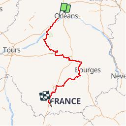
Trail Walking of 313 km to be discovered at Centre-Loire Valley, Loiret, Saint-Ay. This trail is proposed by sash28.

Description

Randonnée sur l'itinéraire du poëte Gaston Couté. itinéraire de 1899.

Elevation profile

Positioning

Country:
France
Region :
Centre-Loire Valley
Department/Province :
Loiret
Municipality :
Saint-Ay
Location:
Unknown
Start:(UTM)
406761 ; 5301140 (31T) N.

Trails nearby

Trail Walking Saint-Ay - ST AY bords de Loire 2 - Photo
Walking

Walking

Difficult
(1)
Saint-Ay, Centre-Loire Valley, Loiret, France
12 km | 13.4 km-effort
2h 57min
Yes
Trail Mountain bike Mézières-lez-Cléry - Les élus Mézière - Photo
Mountain bike
tracegps

Mountain bike

Medium
Mézières-lez-Cléry, Centre-Loire Valley, Loiret, France
13.1 km | 14.4 km-effort
1h 19min
Yes
Trail Walking Mézières-lez-Cléry - Les élus Mézière - Photo
Walking
tracegps

Walking

Easy
Mézières-lez-Cléry, Centre-Loire Valley, Loiret, France
13.1 km | 14.4 km-effort
3h 30min
Yes
Trail Walking Mézières-lez-Cléry - mezieres fevrier 2023 - Photo
Walking
bernard.music

Walking

Medium
Mézières-lez-Cléry, Centre-Loire Valley, Loiret, France
10.6 km | 11.8 km-effort
2h 28min
Yes
Trail Walking Mézières-lez-Cléry - Mézières 6 juin 2021 - Photo
Walking
danieltaillandier

Walking

Medium
Mézières-lez-Cléry, Centre-Loire Valley, Loiret, France
9.9 km | 10.9 km-effort
3h 7min
Yes
Trail Mountain bike Meung-sur-Loire - Les deux ponts - Meung sur Loire - Beaugency - Photo
Mountain bike
tracegps

Mountain bike

Medium
Meung-sur-Loire, Centre-Loire Valley, Loiret, France
17.1 km | 18.4 km-effort
2h 0min
Yes
Trail Walking Meung-sur-Loire - Les deux ponts - Meung sur Loire - Beaugency - Photo
Walking
tracegps

Walking

Medium
Meung-sur-Loire, Centre-Loire Valley, Loiret, France
17.1 km | 18.4 km-effort
4h 0min
Yes
Trail Cycle Cléry-Saint-André - Cléry Saint André - Photo
Cycle
tracegps

Cycle

Easy
Cléry-Saint-André, Centre-Loire Valley, Loiret, France
19.2 km | 20 km-effort
1h 45min
Yes
Trail Road bike Meung-sur-Loire - Beautency - Photo
Road bike
Banaszak

Road bike

Meung-sur-Loire, Centre-Loire Valley, Loiret, France
18 km | 19.7 km-effort
1h 12min
Yes


Close
My subscriptions