Trail Walking Cornas - De la goule à borne chaude - Photo

De la goule à borne chaude

 bredel
bredel

User

© OpenStreetMap contributors
Length
Length
5.7 km
Max alt
Max alt
319 m
Uphill gradient
Uphill gradient
230 m
Km-Effort
Km-Effort  
8.8 km
Min alt
Min alt
113 m
Downhill gradient
Downhill gradient
230 m
Boucle
Boucle
Yes
Creation date :
2018-04-17 13:56:57.539
Updated on :
2018-04-17 13:56:57.539

(0 Reviews)

Walking
Walking
2h18
Difficulty : Easy

Scan this QR Code to open this trail in the SityTrail application

FREE GPS app for hiking

Logo SityTrail SityTrail

IGN / Geographical institutes

Download SityTrail from the App Store Download SityTrail from Google Play

Logo SityTrail SityTrail World

The world is yours!

Download SityTrail from the App Store Download SityTrail from Google Play Download SityTrail on Huawei AppGallery

About

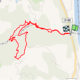
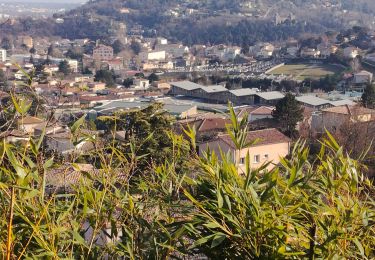
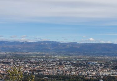
Trail Walking of 5.7 km to be discovered at Auvergne-Rhône-Alpes, Ardèche, Cornas. This trail is proposed by bredel.

Description

Du ruisseau en passant dans le tunnel sous la pesée de la carrière

Elevation profile

Positioning

Country:
France
Region :
Auvergne-Rhône-Alpes
Department/Province :
Ardèche
Municipality :
Cornas
Location:
Unknown
Start:(UTM)
645904 ; 4982282 (31T) N.

Trails nearby

Trail Mountain bike Saint-Péray - Boucle VTT autour de Saint Péray - Photo
Mountain bike
tracegps

Mountain bike

Difficult
(5)
Saint-Péray, Auvergne-Rhône-Alpes, Ardèche, France
31 km | 41 km-effort
2h 0min
Yes
Trail Walking Cornas - De Cornas à la Borne - Photo
Walking
Gilbertbancilhon

Walking

Difficult
(1)
Cornas, Auvergne-Rhône-Alpes, Ardèche, France
12.3 km | 18.3 km-effort
4h 51min
Yes
Trail Walking Saint-Péray - N_ST PERAY 07130 Baume des Bois - Crussol - Photo
Walking
ANDREJAC

Walking

Easy
(2)
Saint-Péray, Auvergne-Rhône-Alpes, Ardèche, France
4.2 km | 6.8 km-effort
1h 40min
Yes
Trail sport La Roche-de-Glun - La Roche de Glun rando école  - Photo
sport
alinetpierre

sport

Very easy
La Roche-de-Glun, Auvergne-Rhône-Alpes, Drôme, France
11.4 km | 15.7 km-effort
Unknown
Yes
Trail Walking Saint-Péray - St Peray - Photo
Walking
ajd26

Walking

Difficult
Saint-Péray, Auvergne-Rhône-Alpes, Ardèche, France
7.6 km | 12.4 km-effort
2h 49min
Yes
Trail Walking Glun - Glun Ardèche  - Photo
Walking
alinetpierre

Walking

Medium
Glun, Auvergne-Rhône-Alpes, Ardèche, France
13.3 km | 18.8 km-effort
2h 58min
Yes
Trail Walking Saint-Péray - saint peray - Photo
Walking
AIGUIER

Walking

Difficult
(1)
Saint-Péray, Auvergne-Rhône-Alpes, Ardèche, France
15 km | 23 km-effort
5h 19min
Yes
Trail Walking Saint-Péray - Le château de Crussol et ses crêtes  - Photo
Walking
prv

Walking

Easy
Saint-Péray, Auvergne-Rhône-Alpes, Ardèche, France
9.9 km | 14.1 km-effort
2h 27min
Yes
Trail Walking Saint-Romain-de-Lerps - barbara - Photo
Walking
Babriders

Walking

Very easy
Saint-Romain-de-Lerps, Auvergne-Rhône-Alpes, Ardèche, France
4.9 km | 6.5 km-effort
1h 25min
Yes


Close
My subscriptions