Trail Walking Lachapelle-aux-Pots - Lachapelle-aux-Pots - autour de la Crapaudière vers 2 - Photo

Lachapelle-aux-Pots - autour de la Crapaudière vers 2

 marcel.F
marcel.F

User

© OpenStreetMap contributors
Length
Length
9.9 km
Max alt
Max alt
145 m
Uphill gradient
Uphill gradient
123 m
Km-Effort
Km-Effort  
11.5 km
Min alt
Min alt
84 m
Downhill gradient
Downhill gradient
123 m
Boucle
Boucle
Yes
Creation date :
2019-04-01 20:22:19.89
Updated on :
2019-04-01 20:22:19.931

(0 Reviews)

Walking
Walking
2h32
Difficulty : Easy

Scan this QR Code to open this trail in the SityTrail application

FREE GPS app for hiking

Logo SityTrail SityTrail

IGN / Geographical institutes

Download SityTrail from the App Store Download SityTrail from Google Play

Logo SityTrail SityTrail World

The world is yours!

Download SityTrail from the App Store Download SityTrail from Google Play Download SityTrail on Huawei AppGallery

About

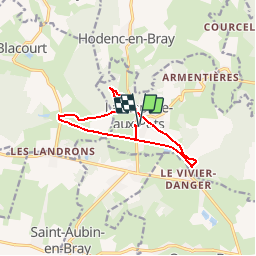
Trail Walking of 9.9 km to be discovered at Hauts-de-France, Oise, Lachapelle-aux-Pots. This trail is proposed by marcel.F.

Description

Lachapelle aux pots direction gare; prendre la voie verte jusqu'à Vivier Danger, puis prendre la route à gauche et au virage le chemin à gauche (rue de la Ferme)  ... puis avant d'arriver à la crapaudière, tourner à droite direction Blacourt, au bout prendre la route à droite puis après La Boissière prendre le chemin noir à gauche jusqu'aux maisons et tourner à gauche puis à gauche la voie verte jusqu'à la gare de Lachapelle aux pots.

Elevation profile

Positioning

Country:
France
Region :
Hauts-de-France
Department/Province :
Oise
Municipality :
Lachapelle-aux-Pots
Location:
Unknown
Start:(UTM)
420381 ; 5477746 (31U) N.

Trails nearby

Trail Mountain bike Lachapelle-aux-Pots - ACTIVE LOG 003 - Photo
Mountain bike
sebcar

Mountain bike

Medium
(1)
Lachapelle-aux-Pots, Hauts-de-France, Oise, France
19.1 km | 24 km-effort
1h 39min
Yes
Trail Mountain bike Pierrefitte-en-Beauvaisis - Grand tour - Photo
Mountain bike
jjeletufe

Mountain bike

(1)
Pierrefitte-en-Beauvaisis, Hauts-de-France, Oise, France
30 km | 35 km-effort
1h 44min
Yes
Trail Walking Senantes - Senantes - Photo
Walking
jpblimond

Walking

Medium
Senantes, Hauts-de-France, Oise, France
18.7 km | 23 km-effort
4h 47min
Yes
Trail Walking Lachapelle-aux-Pots - Lachapelle-aux-pots - Héricourt - La Frénoye - Armentières - Photo
Walking
Marie-Claire-mcp

Walking

Difficult
Lachapelle-aux-Pots, Hauts-de-France, Oise, France
10.7 km | 13.7 km-effort
3h 6min
Yes
Trail Walking Lachapelle-aux-Pots - Lachapelle aux pots - Armentières 11 km - Photo
Walking
Marie-Claire-mcp

Walking

Difficult
Lachapelle-aux-Pots, Hauts-de-France, Oise, France
10.6 km | 13.5 km-effort
3h 4min
Yes
Trail Walking Lachapelle-aux-Pots - Lachapelle aux Pots - Rando santé 1 - Photo
Walking
marcel.F

Walking

Medium
Lachapelle-aux-Pots, Hauts-de-France, Oise, France
5.6 km | 6.4 km-effort
1h 24min
Yes
Trail Walking Lachapelle-aux-Pots - Lachapelle-aux-Pots - autour de la Crapaudière - Photo
Walking
marcel.F

Walking

Easy
Lachapelle-aux-Pots, Hauts-de-France, Oise, France
9.4 km | 10.9 km-effort
2h 25min
Yes
Trail Walking Lachapelle-aux-Pots - Lachapelle aux pots Gare - Photo
Walking
Marie-Claire-mcp

Walking

Medium
Lachapelle-aux-Pots, Hauts-de-France, Oise, France
10.6 km | 12.4 km-effort
2h 37min
Yes
Trail Walking Lachapelle-aux-Pots - Lachapelle aux pots - Photo
Walking
Marie-Claire-mcp

Walking

Easy
Lachapelle-aux-Pots, Hauts-de-France, Oise, France
10.2 km | 12 km-effort
2h 37min
Yes


Close
My subscriptions