Trail Walking Castellane - Site des siréniens (mammifères marins fossiles) - Photo

Site des siréniens (mammifères marins fossiles)

 lviallet
lviallet

User

© OpenStreetMap contributors
Length
Length
4.2 km
Max alt
Max alt
1220 m
Uphill gradient
Uphill gradient
117 m
Km-Effort
Km-Effort  
5.8 km
Min alt
Min alt
1142 m
Downhill gradient
Downhill gradient
118 m
Boucle
Boucle
Yes
Creation date :
2018-04-29 18:26:56.978
Updated on :
2018-04-29 18:26:56.978

(0 Reviews)

Walking
Walking
1h16
Difficulty : Unknown

Scan this QR Code to open this trail in the SityTrail application

FREE GPS app for hiking

Logo SityTrail SityTrail

IGN / Geographical institutes

Download SityTrail from the App Store Download SityTrail from Google Play

Logo SityTrail SityTrail World

The world is yours!

Download SityTrail from the App Store Download SityTrail from Google Play Download SityTrail on Huawei AppGallery

About

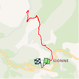
Trail Walking of 4.2 km to be discovered at Provence-Alpes-Côte d'Azur, Alpes-de-Haute-Provence, Castellane. This trail is proposed by lviallet.

Description

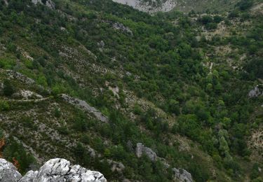
Dans le ravin de Tabori se dissimule un des sites les plus prestigieux de la Réserve naturelle géologique de Haute-Provence. Véritable cimetière marin vieux de 40 millions d’années, le site des siréniens fossiles contient plus de deux cents ossements de mammifères marins proches des dugongs actuels.

Depuis le col des Lèques, l'itinéraire traverse dans un premier temps des prairies, se prolonge dans une forêt de pins avant d'arriver au site aménagé des sirèniens, but de la randonnée.

Elevation profile

Positioning

Country:
France
Region :
Provence-Alpes-Côte d'Azur
Department/Province :
Alpes-de-Haute-Provence
Municipality :
Castellane
Location:
Unknown
Start:(UTM)
296218 ; 4860057 (32T) N.

Trails nearby

Trail Walking Castellane - Sentier des Siréniens  - Photo
Walking
Dervalmarc

Walking

Very easy
(1)
Castellane, Provence-Alpes-Côte d'Azur, Alpes-de-Haute-Provence, France
3.8 km | 5.5 km-effort
1h 9min
Yes
Trail Walking Castellane - cadiere de brandis - Photo
Walking
choux83

Walking

Very easy
(1)
Castellane, Provence-Alpes-Côte d'Azur, Alpes-de-Haute-Provence, France
8.9 km | 14.6 km-effort
2h 27min
No
Trail Walking Castellane - La Baume-Ruines du Vieux Courchons - Photo
Walking
Salomi

Walking

Difficult
(1)
Castellane, Provence-Alpes-Côte d'Azur, Alpes-de-Haute-Provence, France
12.2 km | 18.5 km-effort
4h 11min
Yes
Trail Mountain bike Castellane - vtt-de-castellane-au-lac-de-castillon - Photo
Mountain bike
GUIDE
pascalou73

Mountain bike

Very easy
Castellane, Provence-Alpes-Côte d'Azur, Alpes-de-Haute-Provence, France
14.7 km | 19.5 km-effort
Unknown
Yes
Trail Walking Castellane - Cadières de Brandis - Photo
Walking
jmheydorff

Walking

Medium
(1)
Castellane, Provence-Alpes-Côte d'Azur, Alpes-de-Haute-Provence, France
10.7 km | 18.4 km-effort
3h 51min
Yes
Trail Walking Castellane - La Colle : Cadières de Brandis - Photo
Walking
ETMU5496

Walking

Difficult
Castellane, Provence-Alpes-Côte d'Azur, Alpes-de-Haute-Provence, France
17.5 km | 30 km-effort
6h 54min
Yes
Trail Walking Castellane - 2023-10-27 Sommet de Destourbes - Photo
Walking
GUIDE
Kargil

Walking

Difficult
Castellane, Provence-Alpes-Côte d'Azur, Alpes-de-Haute-Provence, France
13.6 km | 24 km-effort
5h 33min
Yes
Trail Walking Castellane - Clot d'Aremus - Chasteuil - Chapelle St Jean - Castellane - Photo
Walking
LtZIP

Walking

Easy
Castellane, Provence-Alpes-Côte d'Azur, Alpes-de-Haute-Provence, France
14.3 km | 19.8 km-effort
3h 54min
No
Trail Walking Castellane - Col des lèques - Cadières de branlis - Photo
Walking
RayFab

Walking

Difficult
Castellane, Provence-Alpes-Côte d'Azur, Alpes-de-Haute-Provence, France
7.8 km | 13.4 km-effort
3h 2min
Yes


Close
My subscriptions