Trail Walking Castellane - La Baume-Ruines du Vieux Courchons - Photo
 Salomi
Salomi

User

© OpenStreetMap contributors
Length
Length
12.2 km
Max alt
Max alt
1410 m
Uphill gradient
Uphill gradient
469 m
Km-Effort
Km-Effort  
18.5 km
Min alt
Min alt
1042 m
Downhill gradient
Downhill gradient
468 m
Boucle
Boucle
Yes
Creation date :
2022-01-24 15:25:17.831
Updated on :
2024-01-22 18:17:28.743

(1 Reviews)

Walking
Walking
4h11
Difficulty : Difficult

Scan this QR Code to open this trail in the SityTrail application

FREE GPS app for hiking

Logo SityTrail SityTrail

IGN / Geographical institutes

Download SityTrail from the App Store Download SityTrail from Google Play

Logo SityTrail SityTrail World

The world is yours!

Download SityTrail from the App Store Download SityTrail from Google Play Download SityTrail on Huawei AppGallery

About

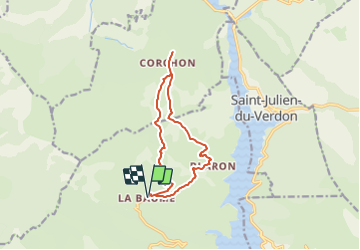
Trail Walking of 12.2 km to be discovered at Provence-Alpes-Côte d'Azur, Alpes-de-Haute-Provence, Castellane. This trail is proposed by Salomi.

Description

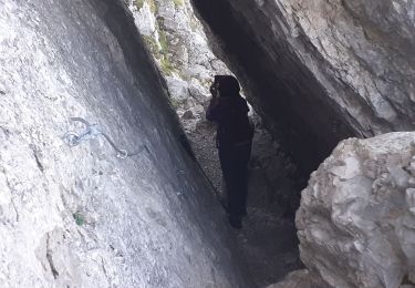
Itinéraire en boucle en face du Pic de Chamatte, de la barre de Pidanoux et du Crémon.
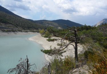
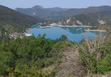
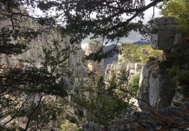
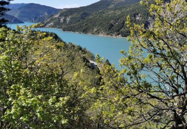
Jolies vues sur le barrage du Castillon. Itinéraire varié.
Rester à distance du monastère du Mandarom.

Elevation profile

Positioning

Country:
France
Region :
Provence-Alpes-Côte d'Azur
Department/Province :
Alpes-de-Haute-Provence
Municipality :
Castellane
Location:
Unknown
Start:(UTM)
299347 ; 4862910 (32T) N.

Comments

Please log in to post a review or rate the element


5


Trails nearby

Trail Walking Castellane - Sentier des Siréniens  - Photo
Walking
Dervalmarc

Walking

Very easy
(1)
Castellane, Provence-Alpes-Côte d'Azur, Alpes-de-Haute-Provence, France
3.8 km | 5.5 km-effort
1h 9min
Yes
Trail Walking Castellane - cadiere de brandis - Photo
Walking
choux83

Walking

Very easy
(1)
Castellane, Provence-Alpes-Côte d'Azur, Alpes-de-Haute-Provence, France
8.9 km | 14.6 km-effort
2h 27min
No
Trail On foot Saint-Julien-du-Verdon - Belvédère du Pidanoux - Photo
On foot
PRO

On foot

Easy
Saint-Julien-du-Verdon, Provence-Alpes-Côte d'Azur, Alpes-de-Haute-Provence, France
7.5 km | 11.7 km-effort
2h 39min
Yes
Trail Walking Castellane - Cadières de Brandis - Photo
Walking
jmheydorff

Walking

Medium
(1)
Castellane, Provence-Alpes-Côte d'Azur, Alpes-de-Haute-Provence, France
10.7 km | 18.4 km-effort
3h 51min
Yes
Trail Walking Castellane - Col des lèques - Cadières de branlis - Photo
Walking
RayFab

Walking

Difficult
Castellane, Provence-Alpes-Côte d'Azur, Alpes-de-Haute-Provence, France
7.8 km | 13.4 km-effort
3h 2min
Yes
Trail Walking Demandolx - le hameau de ville - Photo
Walking
pln30

Walking

Easy
Demandolx, Provence-Alpes-Côte d'Azur, Alpes-de-Haute-Provence, France
4.3 km | 7.8 km-effort
2h 2min
Yes
Trail Walking Castellane - Cadières  de Brandis version Light - Photo
Walking
donda

Walking

Difficult
Castellane, Provence-Alpes-Côte d'Azur, Alpes-de-Haute-Provence, France
9.2 km | 15.4 km-effort
3h 0min
Yes
Trail Walking Castellane - Cadières de Brandis - Photo
Walking
lviallet

Walking

Difficult
Castellane, Provence-Alpes-Côte d'Azur, Alpes-de-Haute-Provence, France
8.8 km | 14.8 km-effort
3h 17min
Yes
Trail Walking Saint-Julien-du-Verdon - St Julien du Verdon-Pidanoux - Photo
Walking
MIKARANDO

Walking

Medium
Saint-Julien-du-Verdon, Provence-Alpes-Côte d'Azur, Alpes-de-Haute-Provence, France
5.5 km | 9.2 km-effort
1h 31min
No


Close
My subscriptions