Randonnée Marche Sentheim - Marché de Masevaux bilan carbone : 0 - Photo

Marché de Masevaux bilan carbone : 0

 helmut68
helmut68

Utilisateur

© OpenStreetMap contributors
Longueur
Longueur
12,7 km
Altitude max
Altitude max
436 m
Dénivelé positif
Dénivelé positif
181 m
Km-Effort
Km-Effort  
15,1 km
Altitude min
Altitude min
360 m
Dénivelé négatif
Dénivelé négatif
181 m
Boucle
Boucle
Oui
Date de création :
2021-08-11 07:11:21.173
Dernière modification :
2021-08-11 11:35:01.966

(0 Avis)

Marche
Marche
2h36
Difficulté : Facile

Scannez ce code QR pour ouvrir la randonnée dans l'application SityTrail

Application GPS de randonnée GRATUITE

Logo SityTrail SityTrail

IGN / Instituts géographiques

Télécharger SityTrail sur l'App Store Télécharger SityTrail sur Google Play

Logo SityTrail SityTrail World

Le monde est à vous

Télécharger SityTrail sur l'App Store Télécharger SityTrail sur Google Play Télécharger SityTrail sur Huawei AppGallery

À propos

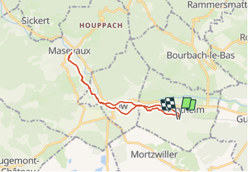
Randonnée Marche de 12,7 km à découvrir à Grand Est, Haut-Rhin, Sentheim. Cette randonnée est proposée par helmut68.

Description

Départ place de jeu de Sentheim en suivant la piste cyclable direction Masevaux , puis suivre le balisage du GR 531 en passant par Lauw , le lac bleu , le collège . Après environ 1 km le marché de Masevaux du mercredi. Retour reprendre le même itinéraire jusqu'au terrain de foot de Lauw . Continuez tout droit , une fois sur la route principale , tournez à gauche sur 100 m puis à droite et continuez toujours tout droit en suivant le balisage " anneau vert " jusqu'à Sentheim ( passage devant la chapelle St Anne ).
Alors à vos chaussures !

Profil altimétrique

Photos

Localisation

Pays :
France
Région :
Grand Est
Département/Province :
Haut-Rhin
Commune :
Sentheim
Localité :
Unknown
Départ:(UTM)
353893 ; 5290545 (32T) N.

Randonnées à proximité

Randonnée Marche Masevaux-Niederbruck - Masevaux - Rossberg par le belvédère du Fuchsfelsen - Photo
Marche
Bart2015

Marche

Moyen
(1)
Masevaux-Niederbruck, Grand Est, Haut-Rhin, France
19,9 km | 34 km-effort
4h 44min
Oui
Randonnée Marche Sentheim - Sentheim Rossberg - Photo
Marche
helmut68

Marche

Moyen
(1)
Sentheim, Grand Est, Haut-Rhin, France
27 km | 40 km-effort
6h 11min
Oui
Randonnée Marche Lauw - 2022-07-14 Marche Lauw Refuge CAF Baerenkopf - Photo
Marche
GUIDE
holtzv

Marche

Très difficile
Lauw, Grand Est, Haut-Rhin, France
18,4 km | 31 km-effort
5h 35min
Non
Randonnée A pied Sentheim - Sentier géologique du Wolfloch - Photo
A pied
PRO

A pied

Facile
Sentheim, Grand Est, Haut-Rhin, France
3,8 km | 4,8 km-effort
1h 5min
Non
Randonnée A pied Sentheim - Sentheim - Bergwald - Eichwald - Guevenheim - Sentheim - Photo
A pied
patrickbeyrath

A pied

Facile
(1)
Sentheim, Grand Est, Haut-Rhin, France
13,4 km | 16,6 km-effort
Inconnu
Oui
Randonnée Marche Sentheim - Randonnée Pentecôte 2024 - Photo
Marche
helmut68

Marche

Moyen
Sentheim, Grand Est, Haut-Rhin, France
14,8 km | 18,3 km-effort
4h 0min
Oui
Randonnée Marche Sentheim - Knapphutte Saegenkopf Hütte - Photo
Marche
helmut68

Marche

Moyen
Sentheim, Grand Est, Haut-Rhin, France
13,8 km | 17,2 km-effort
5h 11min
Oui
Randonnée Marche Sentheim - Montori - Photo
Marche
helmut68

Marche

Moyen
Sentheim, Grand Est, Haut-Rhin, France
17,7 km | 24 km-effort
4h 47min
Oui
Randonnée V.T.T. Sentheim - AperoDioller - Photo
V.T.T.
helmut68

V.T.T.

Facile
Sentheim, Grand Est, Haut-Rhin, France
24 km | 27 km-effort
1h 23min
Oui


Fermer
Mes abonnements