Randonnée Marche Sentheim - SentheimGuew.Sentheim - Photo

SentheimGuew.Sentheim

 helmut68
helmut68

Utilisateur

© OpenStreetMap contributors
Longueur
Longueur
9,6 km
Altitude max
Altitude max
381 m
Dénivelé positif
Dénivelé positif
107 m
Km-Effort
Km-Effort  
11 km
Altitude min
Altitude min
329 m
Dénivelé négatif
Dénivelé négatif
107 m
Boucle
Boucle
Oui
Date de création :
2022-02-27 13:52:36.791
Dernière modification :
2022-02-27 17:04:21.649

(0 Avis)

Marche
Marche
2h15
Difficulté : Facile

Scannez ce code QR pour ouvrir la randonnée dans l'application SityTrail

Application GPS de randonnée GRATUITE

Logo SityTrail SityTrail

IGN / Instituts géographiques

Télécharger SityTrail sur l'App Store Télécharger SityTrail sur Google Play

Logo SityTrail SityTrail World

Le monde est à vous

Télécharger SityTrail sur l'App Store Télécharger SityTrail sur Google Play Télécharger SityTrail sur Huawei AppGallery

À propos

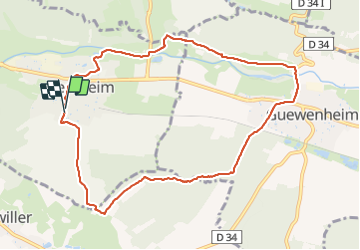
Randonnée Marche de 9,6 km à découvrir à Grand Est, Haut-Rhin, Sentheim. Cette randonnée est proposée par helmut68.

Description

Belle boucle ou à l'aller on longe la Doller rive gauche .Une fois arrivé à l'entrée de Guewenheim ( parcours pieds nus ) traversez le village ( triangle bleu ) pour prendre la direction la chapelle de N.D des Bouleaux.De là suivez le balisage " chevalet jaune " pour le retour à Sentheim.
Alors à vos chaussures !

Profil altimétrique

Photos

Localisation

Pays :
France
Région :
Grand Est
Département/Province :
Haut-Rhin
Commune :
Sentheim
Localité :
Unknown
Départ:(UTM)
353915 ; 5290645 (32T) N.

Randonnées à proximité

Randonnée Marche Masevaux-Niederbruck - Masevaux - Rossberg par le belvédère du Fuchsfelsen - Photo
Marche
Bart2015

Marche

Moyen
(1)
Masevaux-Niederbruck, Grand Est, Haut-Rhin, France
19,9 km | 34 km-effort
4h 44min
Oui
Randonnée Marche Sentheim - Sentheim Rossberg - Photo
Marche
helmut68

Marche

Moyen
(1)
Sentheim, Grand Est, Haut-Rhin, France
27 km | 40 km-effort
6h 11min
Oui
Randonnée Marche Lauw - 2022-07-14 Marche Lauw Refuge CAF Baerenkopf - Photo
Marche
GUIDE
holtzv

Marche

Très difficile
Lauw, Grand Est, Haut-Rhin, France
18,4 km | 31 km-effort
5h 35min
Non
Randonnée A pied Sentheim - Sentier géologique du Wolfloch - Photo
A pied
PRO

A pied

Facile
Sentheim, Grand Est, Haut-Rhin, France
3,8 km | 4,8 km-effort
1h 5min
Non
Randonnée A pied Sentheim - Sentheim - Bergwald - Eichwald - Guevenheim - Sentheim - Photo
A pied
patrickbeyrath

A pied

Facile
(1)
Sentheim, Grand Est, Haut-Rhin, France
13,4 km | 16,6 km-effort
Inconnu
Oui
Randonnée Marche Sentheim - Randonnée Pentecôte 2024 - Photo
Marche
helmut68

Marche

Moyen
Sentheim, Grand Est, Haut-Rhin, France
14,8 km | 18,3 km-effort
4h 0min
Oui
Randonnée Marche Sentheim - Knapphutte Saegenkopf Hütte - Photo
Marche
helmut68

Marche

Moyen
Sentheim, Grand Est, Haut-Rhin, France
13,8 km | 17,2 km-effort
5h 11min
Oui
Randonnée Marche Sentheim - Montori - Photo
Marche
helmut68

Marche

Moyen
Sentheim, Grand Est, Haut-Rhin, France
17,7 km | 24 km-effort
4h 47min
Oui
Randonnée V.T.T. Sentheim - AperoDioller - Photo
V.T.T.
helmut68

V.T.T.

Facile
Sentheim, Grand Est, Haut-Rhin, France
24 km | 27 km-effort
1h 23min
Oui


Fermer
Mes abonnements