Randonnée Marche Uffholtz - 68 Uffholtz - Wattwiller - Photo

68 Uffholtz - Wattwiller

 E.BURCK
E.BURCK

Utilisateur

© OpenStreetMap contributors
Longueur
Longueur
9,5 km
Altitude max
Altitude max
539 m
Dénivelé positif
Dénivelé positif
275 m
Km-Effort
Km-Effort  
13,2 km
Altitude min
Altitude min
303 m
Dénivelé négatif
Dénivelé négatif
276 m
Boucle
Boucle
Oui
Date de création :
2023-02-21 16:31:12.49
Dernière modification :
2023-02-21 16:44:39.546

(0 Avis)

Marche
Marche
3h31
Difficulté : Moyen

Scannez ce code QR pour ouvrir la randonnée dans l'application SityTrail

Application GPS de randonnée GRATUITE

Logo SityTrail SityTrail

IGN / Instituts géographiques

Télécharger SityTrail sur l'App Store Télécharger SityTrail sur Google Play

Logo SityTrail SityTrail World

Le monde est à vous

Télécharger SityTrail sur l'App Store Télécharger SityTrail sur Google Play Télécharger SityTrail sur Huawei AppGallery

À propos

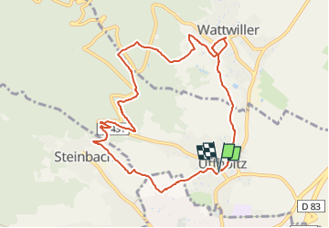
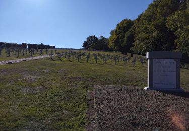
Randonnée Marche de 9,5 km à découvrir à Grand Est, Haut-Rhin, Uffholtz. Cette randonnée est proposée par E.BURCK.

Description

Une balade connue avec peu de dénivelé : 280m le matin
et 60 m l'après midi sur 11km au total.            
ACCÈS :
- à Uffholtz

PARKING :
3, rue Bernard Meyer Uffholtz
47.81915 ,   7.178677   ou
N 47°49'09"      E  07°10'43"      
           

RESTAURATION :    
Fin Gourmet à Wattwiller  
Tel.: 03 89 75 75 00

Profil altimétrique

Localisation

Pays :
France
Région :
Grand Est
Département/Province :
Haut-Rhin
Commune :
Uffholtz
Localité :
Unknown
Départ:(UTM)
363662 ; 5297796 (32T) N.

Randonnées à proximité

Randonnée Marche Soultz-Haut-Rhin - Hartmannswillerkopf - Circuit découverte - Photo
Marche
VacheKiri67

Marche

Facile
(1)
Soultz-Haut-Rhin, Grand Est, Haut-Rhin, France
3,6 km | 5,2 km-effort
1h 46min
Oui
Randonnée Marche Soultz-Haut-Rhin - Hartmannswillerkopf - Circuit anneau bleu - Photo
Marche
VacheKiri67

Marche

Moyen
(1)
Soultz-Haut-Rhin, Grand Est, Haut-Rhin, France
3,7 km | 5,9 km-effort
1h 37min
Oui
Randonnée Autre activité Steinbach - lac du ballon - Photo
Autre activité
rodabruna

Autre activité

Très facile
(1)
Steinbach, Grand Est, Haut-Rhin, France
33 km | 64 km-effort
5h 1min
Non
Randonnée Trail Wattwiller - The History Ultra - Stage 1 - Photo
Trail
Olivier Houette

Trail

Très facile
(1)
Wattwiller, Grand Est, Haut-Rhin, France
28 km | 48 km-effort
Inconnu
Non
Randonnée Marche Uffholtz - Molkenrain 1 - Photo
Marche
regisbodilis

Marche

Difficile
(1)
Uffholtz, Grand Est, Haut-Rhin, France
15,4 km | 26 km-effort
4h 0min
Oui
Randonnée Marche Steinbach - Rando CLAS du 02/11/2023 - Photo
Marche
boubou68

Marche

Très difficile
Steinbach, Grand Est, Haut-Rhin, France
17,7 km | 27 km-effort
4h 35min
Oui
Randonnée Marche Steinbach - Rando Marcheurs du 03/07/2023 par ALAIN - Photo
Marche
boubou68

Marche

Très difficile
Steinbach, Grand Est, Haut-Rhin, France
20 km | 34 km-effort
5h 1min
Oui
Randonnée Marche Wattwiller - Wattwiller - Domaine du Hirtz (30/03/2023) - Photo
Marche
Richard68500

Marche

Facile
Wattwiller, Grand Est, Haut-Rhin, France
6,1 km | 9,9 km-effort
2h 7min
Oui
Randonnée Vélo de route Cernay - Le Grand ballon de Cernay  - Photo
Vélo de route
nadd73

Vélo de route

Difficile
Cernay, Grand Est, Haut-Rhin, France
23 km | 36 km-effort
2h 15min
Non


Fermer
Mes abonnements