Randonnée Marche Bourbach-le-Haut - 68 Bourbach le Haut - Buissonnets - Photo

68 Bourbach le Haut - Buissonnets

 E.BURCK
E.BURCK

Utilisateur

© OpenStreetMap contributors
Longueur
Longueur
10,3 km
Altitude max
Altitude max
933 m
Dénivelé positif
Dénivelé positif
470 m
Km-Effort
Km-Effort  
16,6 km
Altitude min
Altitude min
536 m
Dénivelé négatif
Dénivelé négatif
469 m
Boucle
Boucle
Oui
Date de création :
2019-05-22 16:12:28.825
Dernière modification :
2020-07-14 13:25:22.237

(1 Avis)

Marche
Marche
--
Difficulté : Moyen

Scannez ce code QR pour ouvrir la randonnée dans l'application SityTrail

Application GPS de randonnée GRATUITE

Logo SityTrail SityTrail

IGN / Instituts géographiques

Télécharger SityTrail sur l'App Store Télécharger SityTrail sur Google Play

Logo SityTrail SityTrail World

Le monde est à vous

Télécharger SityTrail sur l'App Store Télécharger SityTrail sur Google Play Télécharger SityTrail sur Huawei AppGallery

À propos

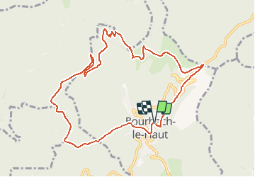
Randonnée Marche de 10,3 km à découvrir à Grand Est, Haut-Rhin, Bourbach-le-Haut. Cette randonnée est proposée par E.BURCK.

Description

ACCÈS :
-Par Guewenheim, puis à droite à l'entrée de Sentheim prendre Bourbach le bas puis Bourbach le Haut.

PARKING :
- à l'entrée de Bourbach le haut prendre à droite une petite route qui descend vers la salle familiale et son parking.

47.7969001, 7.0308683  ou  
N 47°47'49", E 007°01'51"
           
RESTAURATION : Auberge des Buissonnets
Tél.: 03 89 38 85 87

Profil altimétrique

Localisation

Pays :
France
Région :
Grand Est
Département/Province :
Haut-Rhin
Commune :
Bourbach-le-Haut
Localité :
Unknown
Départ:(Dec)
Départ:(UTM)
352544 ; 5295612 (32T) N.

Commentaires

Veuillez vous connecter pour laisser un commentaire ou une note


Randonnées à proximité

Randonnée Marche Masevaux-Niederbruck - Masevaux - Rossberg par le belvédère du Fuchsfelsen - Photo
Marche
Bart2015

Marche

Moyen
(1)
Masevaux-Niederbruck, Grand Est, Haut-Rhin, France
19,9 km | 34 km-effort
4h 44min
Oui
Randonnée Marche Sentheim - Sentheim Rossberg - Photo
Marche
helmut68

Marche

Moyen
(1)
Sentheim, Grand Est, Haut-Rhin, France
27 km | 40 km-effort
6h 11min
Oui
Randonnée Marche Bourbach-le-Haut - Tour du Rossberg - Gsang - Thannerhubel - Photo
Marche
GUIDE
mumu.larandonneuse

Marche

Difficile
Bourbach-le-Haut, Grand Est, Haut-Rhin, France
11,4 km | 18,5 km-effort
4h 12min
Oui
Randonnée Marche Lauw - 2022-07-14 Marche Lauw Refuge CAF Baerenkopf - Photo
Marche
GUIDE
holtzv

Marche

Très difficile
Lauw, Grand Est, Haut-Rhin, France
18,4 km | 31 km-effort
5h 35min
Non
Randonnée A pied Sentheim - Sentier géologique du Wolfloch - Photo
A pied
PRO

A pied

Facile
Sentheim, Grand Est, Haut-Rhin, France
3,8 km | 4,8 km-effort
1h 5min
Non
Randonnée A pied Sentheim - Sentheim - Bergwald - Eichwald - Guevenheim - Sentheim - Photo
A pied
patrickbeyrath

A pied

Facile
(1)
Sentheim, Grand Est, Haut-Rhin, France
13,4 km | 16,6 km-effort
Inconnu
Oui
Randonnée A pied Bitschwiller-lès-Thann - Bitschwiller les Thann - Rehbrunnel - Abri du Becherkopf - Roche Albert - Photo
A pied
patrickbeyrath

A pied

Moyen
(1)
Bitschwiller-lès-Thann, Grand Est, Haut-Rhin, France
10,3 km | 16,4 km-effort
Inconnu
Oui
Randonnée Marche Bitschwiller-lès-Thann - 68 Col du Hundsrück  - FA Gsang - retour ThannerHubel - Photo
Marche

Marche

Moyen
(1)
Bitschwiller-lès-Thann, Grand Est, Haut-Rhin, France
11,2 km | 18,4 km-effort
3h 48min
Oui
Randonnée Marche Masevaux-Niederbruck - Rando CLAS du 25/04/2024 - Photo
Marche
boubou68

Marche

Très difficile
Masevaux-Niederbruck, Grand Est, Haut-Rhin, France
17 km | 28 km-effort
4h 24min
Oui


Fermer
Mes abonnements