Trail Walking Banyuls-sur-Mer - Banyuls Port Bou par le littoral - Photo

Banyuls Port Bou par le littoral

 perpi13
perpi13

User

© OpenStreetMap contributors
Length
Length
14.7 km
Max alt
Max alt
196 m
Uphill gradient
Uphill gradient
517 m
Km-Effort
Km-Effort  
22 km
Min alt
Min alt
0 m
Downhill gradient
Downhill gradient
519 m
Boucle
Boucle
No
Creation date :
2019-02-23 22:15:03.002
Updated on :
2019-02-23 22:15:03.11

(0 Reviews)

Walking
Walking
3h30
Difficulty : Medium

Scan this QR Code to open this trail in the SityTrail application

FREE GPS app for hiking

Logo SityTrail SityTrail

IGN / Geographical institutes

Download SityTrail from the App Store Download SityTrail from Google Play

Logo SityTrail SityTrail World

The world is yours!

Download SityTrail from the App Store Download SityTrail from Google Play Download SityTrail on Huawei AppGallery

About

Trail Walking of 14.7 km to be discovered at Occitania, Pyrénées-Orientales, Banyuls-sur-Mer. This trail is proposed by perpi13.

Elevation profile

Photos

Points of interest

Point of interest Banyuls-sur-Mer - la jeune fille allongée Maillol - Photo
perpi13
Point of interest Banyuls-sur-Mer - montée dangereuse en cas de vent direction SUD - Photo
perpi13
Point of interest Banyuls-sur-Mer - Cabail Bernat - Photo
perpi13
BANYULS-SUR-MER 
Point of interest Banyuls-sur-Mer - cap Rederis vue N - Photo
perpi13
BANYULS-SUR-MER 
Point of interest Banyuls-sur-Mer - cap Rederis vue S - Photo
perpi13
BANYULS-SUR-MER 
Point of interest Banyuls-sur-Mer - anse Peyrefitte - Photo
perpi13
BANYULS-SUR-MER 
Point of interest Cerbère - Cerbère - Photo
perpi13
CERBÈRE 
Point of interest Cerbère - frontière borne 601 - Photo
perpi13
Point of interest Portbou - Port Bou - Photo
perpi13
PORTBOU 
Point of interest Portbou - plage port bou - Photo
perpi13

Positioning

Country:
France
Region :
Occitania
Department/Province :
Pyrénées-Orientales
Municipality :
Banyuls-sur-Mer
Location:
Unknown
Start:(UTM)
510631 ; 4703444 (31T) N.

Trails nearby

Trail Walking Port-Vendres - Le sentier des douaniers (Port-Vendres) - Photo
Walking
tracegps

Walking

Medium
(5)
Port-Vendres, Occitania, Pyrénées-Orientales, France
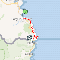
14.5 km | 19.1 km-effort
4h 0min
Yes
Trail Walking Port-Vendres - PORT-VENDRES 66 - Sentier littoral jusqu'à BANYULS-SUR-MER - retour par l'arrière pays et le vignoble - Photo
Walking
jeff66

Walking

Medium
(2)
Port-Vendres, Occitania, Pyrénées-Orientales, France
10.1 km | 14 km-effort
2h 21min
Yes
Trail Walking Banyuls-sur-Mer - BANYULS- SUR-MER 66 - Sentier littoral - cap Rederis - col de la Creu - Photo
Walking
jeff66

Walking

Difficult
(2)
Banyuls-sur-Mer, Occitania, Pyrénées-Orientales, France
15.1 km | 22 km-effort
3h 45min
Yes
Trail Walking Banyuls-sur-Mer - Littoral Banyuls-Cerbere - Photo
Walking
perittel

Walking

Medium
(1)
Banyuls-sur-Mer, Occitania, Pyrénées-Orientales, France
13.6 km | 18.8 km-effort
4h 33min
Yes
Trail Walking Port-Vendres - port vendres - Photo
Walking
perittel

Walking

Very easy
(1)
Port-Vendres, Occitania, Pyrénées-Orientales, France
10.9 km | 14.8 km-effort
3h 42min
Yes
Trail Walking Banyuls-sur-Mer - Banyuls Cerbère - Littoral retour bus - 10km 4h 320m déniv. - Photo
Walking
jopost

Walking

Difficult
(1)
Banyuls-sur-Mer, Occitania, Pyrénées-Orientales, France
10 km | 14.3 km-effort
4h 12min
No
Trail Walking Banyuls-sur-Mer - RP 66 BANYULS SUR MER - PUIG del Mas - PUIG JOAN - le 10.03.2017 - Photo
Walking
jeff66

Walking

Medium
(1)
Banyuls-sur-Mer, Occitania, Pyrénées-Orientales, France
9.7 km | 16 km-effort
2h 21min
Yes
Trail Walking Banyuls-sur-Mer - Banyuls sur Mer, chapelle notre Dame de la Salette - Photo
Walking
nandaf

Walking

Banyuls-sur-Mer, Occitania, Pyrénées-Orientales, France
6.7 km | 10.5 km-effort
2h 47min
Yes
Trail Walking Port-Vendres - anse des paulilles - cap bear / retour par les vignes - Photo
Walking
stef789

Walking

Medium
Port-Vendres, Occitania, Pyrénées-Orientales, France
5 km | 7.1 km-effort
2h 41min
Yes


Close
My subscriptions